The Larsen's Beach Trail at Larsen's Beach near Kilauea, Hawaii (Kauai) is a moderate 0.5-mile out-and-back trail that leads down to the beautiful Larsen's (Larson's) Beach.
Hike Description
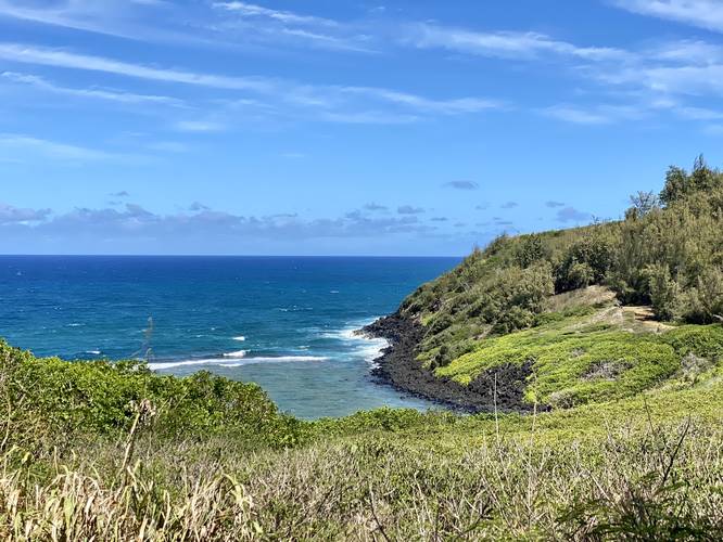
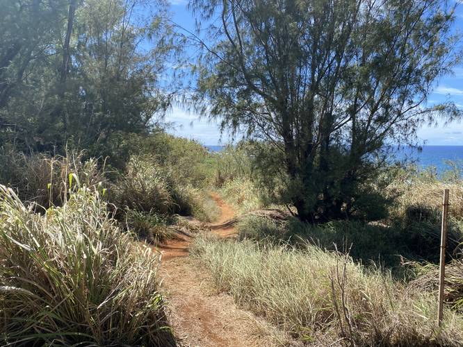
While this trail is short, it's worth noting that it's certainly more of a hike than a quick beach access walk. The trail follows a mostly-flat grade before it begins its ~140-foot descent near the wooden caution sign that's posted on a tree. Beach-goers should note that as of June 2022, 14 people have died here, likely from accidental drowning due to swimming in these strong currents. It's advise that, since there's no lifeguard on duty and since the current can be dangerous, to not swim in the waters of Larsen's Beach.
Just beyond the wooden caution sign, the trail will follow a steeper grade as it meanders its way through large rocks on a skinny path. Due to this, it's best to wear shoes along the trail and thus wait to change into flip-flops after you've reached the beach. Eventually, the trail will pop out on Larsen's Beach under a tree - the annoying hike down is over and you can now enjoy the beautiful waters and some seclusion of Larsen's Beach.
Parking
Beach-goers will find public parking at the very end of Larsen Beach Rd (Larson Beach Rd). The lot is large enough to fit about 20 vehicles or so; however, due to the lack of easy access to the beach, it's not very popular compared to other beaches in the area.
Clothing-Optional Beach
This beach is an unofficial clothing-optional beach, which apparently has been that way since the 1990's if not earlier. This is also a family beach. Upon our visit, despite hanging out for 20 minutes on the eastern end of the beach, we witnessed both - clothed families like a normal beach but also one older gentleman beach walking in his birthday suit. No judgement, no harm, no foul, but it's worth noting that this is in fact a clothing-optional beach.
"Larsen's Beach" vs "Larson's Beach"
According to many local articles and books, this beach is known as "Larsen's Beach"; however, many maps label is as "Larson's Beach".
"Zuckerland" - Mark Zuckerburg's Abutting Private Property
Hikers and visitors may notice the white and blue "private property" signs located along a 5-foot tall volcanic rock wall that lines 80% of Koolau Road while driving in - this is Mark Zuckerburg and Priscilla Chan's private residence. Other guides have label this their maps as "Zuckerland". The property extends along the entire length of the western side of Larsen Beach Road. Thankfully, this trail, and Larsen's Beach access, is open to the public; however, according to the Kauai property map, the access trail does pass through a slice of this private property. Fun fact - this private property, according to the State of Hawaii as of July 2022, is worth ~$10.5M "Market Value" while the property tax for this ~600 acre property was only $10,200 for 2022! That's a 0.00097% property tax rate at a low-ball "market value". At the assessed value of $1.3M it's a 0.00783% tax rate... what a steal for the world's 5th richest person.
Respecting the Land
Hawaiian land is considered sacred to native Hawaiians and many locals, so please stay on-trail, take nothing but photos, and leave nothing but footprints. Respect the locals - don't stay for long and have a backup hike planned in case the parking lot is full.
Hike Description
While this trail is short, it's worth noting that it's certainly more of a hike than a quick beach access walk. The trail follows a mostly-flat grade before it begins its ~140-foot descent near the wooden caution sign that's posted on a tree. Beach-goers should note that as of June 2022, 14 people have died here, likely from accidental drowning due to swimming in these strong currents. It's advise that, since there's no lifeguard on duty and since the current can be dangerous, to not swim in the waters of Larsen's Beach.
Just beyond the wooden caution sign, the trail will follow a steeper grade as it meanders its way through large rocks on a skinny path. Due to this, it's best to wear shoes along the trail and thus wait to change into flip-flops after you've reached the beach. Eventually, the trail will pop out on Larsen's Beach under a tree - the annoying hike down is over and you can now enjoy the beautiful waters and some seclusion of Larsen's Beach.
Parking
Beach-goers will find public parking at the very end of Larsen Beach Rd (Larson Beach Rd). The lot is large enough to fit about 20 vehicles or so; however, due to the lack of easy access to the beach, it's not very popular compared to other beaches in the area.
Clothing-Optional Beach
This beach is an unofficial clothing-optional beach, which apparently has been that way since the 1990's if not earlier. This is also a family beach. Upon our visit, despite hanging out for 20 minutes on the eastern end of the beach, we witnessed both - clothed families like a normal beach but also one older gentleman beach walking in his birthday suit. No judgement, no harm, no foul, but it's worth noting that this is in fact a clothing-optional beach.
"Larsen's Beach" vs "Larson's Beach"
According to many local articles and books, this beach is known as "Larsen's Beach"; however, many maps label is as "Larson's Beach".
"Zuckerland" - Mark Zuckerburg's Abutting Private Property
Hikers and visitors may notice the white and blue "private property" signs located along a 5-foot tall volcanic rock wall that lines 80% of Koolau Road while driving in - this is Mark Zuckerburg and Priscilla Chan's private residence. Other guides have label this their maps as "Zuckerland". The property extends along the entire length of the western side of Larsen Beach Road. Thankfully, this trail, and Larsen's Beach access, is open to the public; however, according to the Kauai property map, the access trail does pass through a slice of this private property. Fun fact - this private property, according to the State of Hawaii as of July 2022, is worth ~$10.5M "Market Value" while the property tax for this ~600 acre property was only $10,200 for 2022! That's a 0.00097% property tax rate at a low-ball "market value". At the assessed value of $1.3M it's a 0.00783% tax rate... what a steal for the world's 5th richest person.
Respecting the Land
Hawaiian land is considered sacred to native Hawaiians and many locals, so please stay on-trail, take nothing but photos, and leave nothing but footprints. Respect the locals - don't stay for long and have a backup hike planned in case the parking lot is full.