Larry's Creek Trail at State Game Lands 114 in Cogan House Township, Pennsylvania is a moderate 3.6-mile out-and-back hike that features an off-trail waterfall and scenic views of rhododendron and rock ledges along the creek.
Hike
This hike begins at the very-end of State Game Land Road just south of Campell Road and Covered Bridge Road in Cogan House Township. Hikers will find a large parking turnout with State Game Lands (SGL) signage located on a small footbridge. Here, the service road nicknamed Larry's Creek Trail begins.
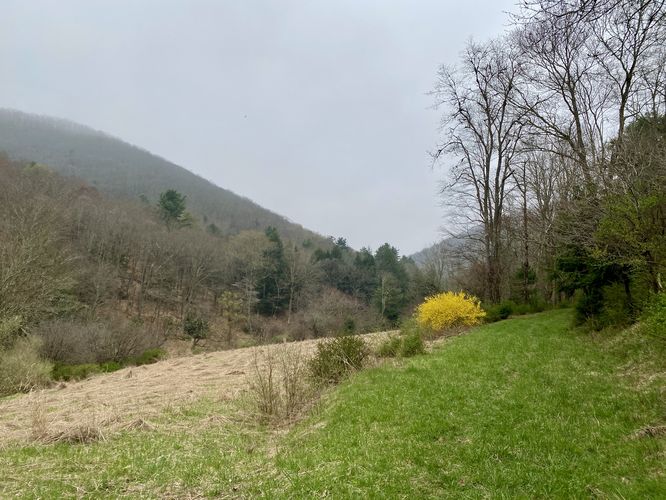
Views - Mile 0
Right off the bat, hikers will find an open clearing of land that provides a view into the mountainous terrain that the trail leads into. The view is from the valley floor below the rounded mountains, but it's a pretty sight nonetheless.
The trail then leads into the woods heading southward as it follows the old service road. Along the way you'll hear the rushing waters of Larry's Creek further down in the valley below as the trail tends to keep in higher elevation on the mountain slopes rather than following along side the creek. The trail can be very muddy in spots, so watch your step!
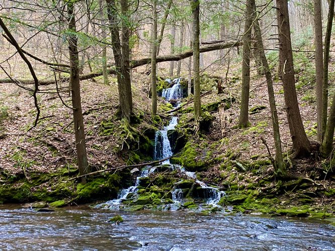
Off-Trail 15-foot Waterfall - Mile 0.85
Once you reach mile 0.8, during snow melt or rainy seasons, you may notice cascading waters falling into Larry's Creek in the valley below. Here, you can hike off-trail to mile 0.85 where you'll find a multi-tiered waterfall that spills into Larry's Creek. The total height of the cascade is about 15-feet or slightly shorter with a ~4 or 5-foot tall upper tier and a ~10-foot tall lower tier. The waterfall is accompanied by an abundance of moss, which makes for a really nice stop along the hike.
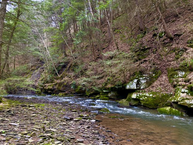
Larry's Creek Ledges - Mile 0.9
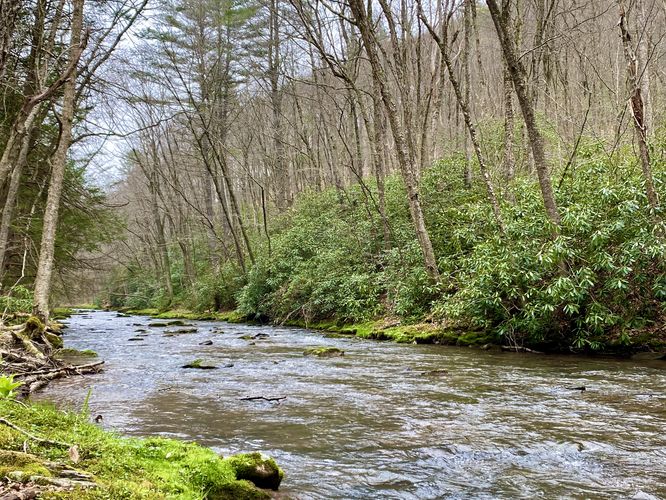
Just downstream from the waterfall is a scenic view of Larry's Creek with tall rock ledges that define the base of the mountains east of the creek. This spot is worth walking off-trail to view as well.
Hiking Up - Mile 0.9 to 1
The hike back up from Larry's Creek to reach the service road is about 0.1-miles long (depending on how much of an angle you hike to it). There's also a very-skinny log slide path that you'll find on your way back to the road. Just keep hiking up about 500 horizontal feet until you reach the wider path you were on previously.
Rhododendron & Rock Slides - Mile 1.6 to 1.8
Around mile 1.6, after dodging muddy sections, you'll reach a part of the trail that includes tall and old rhododendrons - during early Summer, these plants probably smell amazing with their adorning wildflowers. Just beyond the rows of rhododendron is where the trail opens up a bit more - likely due to the steep rocky slopes that line the mountainside here. This area may provide for some fun scrambling opportunities, but may also be home to Timber Rattlesnakes as those rocks make for a great spot to make a nest.
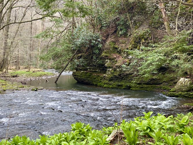
End of Trail & Views - Mile 1.9
At mile 1.9, hikers will reach the end of the trail where you'll find two different scenic "views" of Larry's Creek. Facing southward are moss rock ledges that line the creek. To the north, the creek's banks are covered in moss with rhododendron as far as the eye can see. If you have waders and are adventurous, Larry's Creek and SGL 114 likely have more to offer; however, my first hike to Larry's Creek ended here, though I plan to come back in the future. Also, random to note: there's a picture of an old-timer hunter located on a rock step below a tree -- this appears to be a memorial of sorts (assumed) and maybe this was this man's favorite spot to hunt and fish.
Hiking Out - Mile 1.9 to 3.6
The hike out is easy but mostly-all uphill. The uphill hiking should not be considered any more difficult than "easy" in my opinion, but you'll spend time dodging mud puddles once more. Some of which can be a bit deep, so watch out.
Difficulty
This hike should be considered moderate only for the steep hillside climb you must complete to visit the off-trail waterfall. If you skip the waterfall entirely and only stay on-trail at all times, this hike should be considered easy.
Parking
Hikers will find a large parking turnout at the very-end of State Game Land Road just south of Campell Road and Covered Bridge Road in Cogan House Township - at the coordinates provided.
Pets
Dogs are allowed only if leashed and must be cleaned up after.
Warnings
Timber Rattlesnake: This area is home to the Timber Rattlesnake which can be found roaming the forest or drinking near creeks and water sources between the end of April and early October each year. Due to the rocky outcroppings and steep mountain slopes, this area is likely a habitat for some native rattlers. Be on the lookout and give any you find plenty of space.
Muddy spots: This trail passes through sections of water drainage that tend to pool up on the trail. This causes large mud spots to appear especially during wet and rainy seasons. Watch your step.
Off-trail hiking: This route includes some off-trail navigation. Do not hike off-trail unless you feel comfortable.
Hike
This hike begins at the very-end of State Game Land Road just south of Campell Road and Covered Bridge Road in Cogan House Township. Hikers will find a large parking turnout with State Game Lands (SGL) signage located on a small footbridge. Here, the service road nicknamed Larry's Creek Trail begins.
Views - Mile 0
Right off the bat, hikers will find an open clearing of land that provides a view into the mountainous terrain that the trail leads into. The view is from the valley floor below the rounded mountains, but it's a pretty sight nonetheless.
The trail then leads into the woods heading southward as it follows the old service road. Along the way you'll hear the rushing waters of Larry's Creek further down in the valley below as the trail tends to keep in higher elevation on the mountain slopes rather than following along side the creek. The trail can be very muddy in spots, so watch your step!
Off-Trail 15-foot Waterfall - Mile 0.85
Once you reach mile 0.8, during snow melt or rainy seasons, you may notice cascading waters falling into Larry's Creek in the valley below. Here, you can hike off-trail to mile 0.85 where you'll find a multi-tiered waterfall that spills into Larry's Creek. The total height of the cascade is about 15-feet or slightly shorter with a ~4 or 5-foot tall upper tier and a ~10-foot tall lower tier. The waterfall is accompanied by an abundance of moss, which makes for a really nice stop along the hike.
Larry's Creek Ledges - Mile 0.9
Just downstream from the waterfall is a scenic view of Larry's Creek with tall rock ledges that define the base of the mountains east of the creek. This spot is worth walking off-trail to view as well.
Hiking Up - Mile 0.9 to 1
The hike back up from Larry's Creek to reach the service road is about 0.1-miles long (depending on how much of an angle you hike to it). There's also a very-skinny log slide path that you'll find on your way back to the road. Just keep hiking up about 500 horizontal feet until you reach the wider path you were on previously.
Rhododendron & Rock Slides - Mile 1.6 to 1.8
Around mile 1.6, after dodging muddy sections, you'll reach a part of the trail that includes tall and old rhododendrons - during early Summer, these plants probably smell amazing with their adorning wildflowers. Just beyond the rows of rhododendron is where the trail opens up a bit more - likely due to the steep rocky slopes that line the mountainside here. This area may provide for some fun scrambling opportunities, but may also be home to Timber Rattlesnakes as those rocks make for a great spot to make a nest.
End of Trail & Views - Mile 1.9
At mile 1.9, hikers will reach the end of the trail where you'll find two different scenic "views" of Larry's Creek. Facing southward are moss rock ledges that line the creek. To the north, the creek's banks are covered in moss with rhododendron as far as the eye can see. If you have waders and are adventurous, Larry's Creek and SGL 114 likely have more to offer; however, my first hike to Larry's Creek ended here, though I plan to come back in the future. Also, random to note: there's a picture of an old-timer hunter located on a rock step below a tree -- this appears to be a memorial of sorts (assumed) and maybe this was this man's favorite spot to hunt and fish.
Hiking Out - Mile 1.9 to 3.6
The hike out is easy but mostly-all uphill. The uphill hiking should not be considered any more difficult than "easy" in my opinion, but you'll spend time dodging mud puddles once more. Some of which can be a bit deep, so watch out.
Difficulty
This hike should be considered moderate only for the steep hillside climb you must complete to visit the off-trail waterfall. If you skip the waterfall entirely and only stay on-trail at all times, this hike should be considered easy.
Parking
Hikers will find a large parking turnout at the very-end of State Game Land Road just south of Campell Road and Covered Bridge Road in Cogan House Township - at the coordinates provided.
Pets
Dogs are allowed only if leashed and must be cleaned up after.
Warnings
Timber Rattlesnake: This area is home to the Timber Rattlesnake which can be found roaming the forest or drinking near creeks and water sources between the end of April and early October each year. Due to the rocky outcroppings and steep mountain slopes, this area is likely a habitat for some native rattlers. Be on the lookout and give any you find plenty of space.
Muddy spots: This trail passes through sections of water drainage that tend to pool up on the trail. This causes large mud spots to appear especially during wet and rainy seasons. Watch your step.
Off-trail hiking: This route includes some off-trail navigation. Do not hike off-trail unless you feel comfortable.