The Lake Irene Trail at Rocky Mountain National Park near Grand Lake, Colorado is an easy 0.3-mile out-and-back hike that leads to the northeast shores of Lake Irene and features beautiful views of this subalpine lake.
Hike
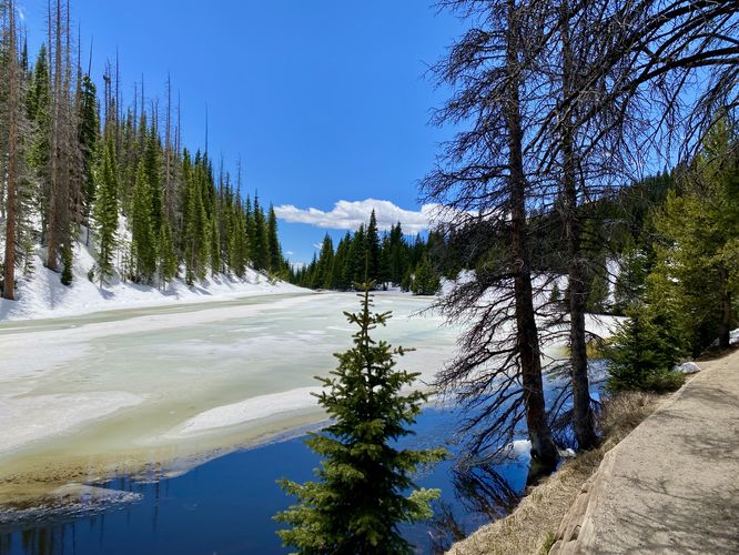
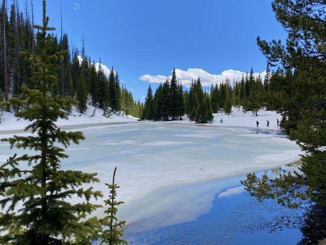
This short hike begins at the southern side of the main parking lot for Lake Irene and follows the dirt trail as it leads downhill toward the lake. During our hike here in early June 2024, there was still plenty of snow in the forest here and across the trail -- at least 3-feet deep in most places. Postholing was a slight issue, but we followed the densely-packed snow trail down the hill to reach the northeast shore of Lake Irene. From the trail and shore, you'll find beautiful views of the lake, despite being semi-frozen over or not based on the season you visit. Once you're done taking in the views of this small but scenic subalpin lake, the walk back to parking is generally easy but all uphill. Also worth noting that this is a great trail to become more acclimated to the high altitude mountains.
Pets
Dogs are not allowed on this trail.
Parking
Hikers will find a medium-sized parking lot at the coordinates provided, located on Trail Ridge Road at the Lake Irene Picnic Area. The lot is large enough to fit a couple dozen vehicles as of June 2024.
Wildlife Viewing
This trail is great for viewing wildlife, especially deer, elk, and moose due to the lake's water source for drinking. If you wish to spot wildlife, your best chances are in the early morning or in the early evening. Always keep a safe distance while viewing - approx. 75-feet for elk and longhorn sheep; 120-feet for bear and moose.
Timed-Entry Reservations
Between the months of late May through early October you must purchase a timed-entry pass to visit Rocky Mountain National Park. If you wish to visitor and hike anything off of the Bear Lake Road, you must purchase a dedicated Bear Lake timed-entry pass. You can find more information about timed entry on the park's website.
Warnings
Elevation sickness: This trail brings hikers through terrain that ascends up to 10,600-feet above sea level. Around the 7,000-foot mark above sea level, hikers may start to experience symptoms of elevation sickness including headache, muscle aches, shortness of breath, among other warning signs. In order to avoid elevation sickness it's recommended to ascend to higher elevations and take short walks to acclimate over the course of several days before taking a long or physically-demanding hike. At any time you feel elevation sickness kicking in, that's the time to turn back and head for lower altitude or the parking lot.
Wild animals: While rare, hikers may encounter bears or mountain lion along the trail. Again, this is rare due to the insane amount of people who hike these trails each day; however, it's smart to know that these wild animals could be on-trail. Please read-up on how to properly handle a bear or mountain lion encounter before hitting the trails.
Hike
This short hike begins at the southern side of the main parking lot for Lake Irene and follows the dirt trail as it leads downhill toward the lake. During our hike here in early June 2024, there was still plenty of snow in the forest here and across the trail -- at least 3-feet deep in most places. Postholing was a slight issue, but we followed the densely-packed snow trail down the hill to reach the northeast shore of Lake Irene. From the trail and shore, you'll find beautiful views of the lake, despite being semi-frozen over or not based on the season you visit. Once you're done taking in the views of this small but scenic subalpin lake, the walk back to parking is generally easy but all uphill. Also worth noting that this is a great trail to become more acclimated to the high altitude mountains.
Pets
Dogs are not allowed on this trail.
Parking
Hikers will find a medium-sized parking lot at the coordinates provided, located on Trail Ridge Road at the Lake Irene Picnic Area. The lot is large enough to fit a couple dozen vehicles as of June 2024.
Wildlife Viewing
This trail is great for viewing wildlife, especially deer, elk, and moose due to the lake's water source for drinking. If you wish to spot wildlife, your best chances are in the early morning or in the early evening. Always keep a safe distance while viewing - approx. 75-feet for elk and longhorn sheep; 120-feet for bear and moose.
Timed-Entry Reservations
Between the months of late May through early October you must purchase a timed-entry pass to visit Rocky Mountain National Park. If you wish to visitor and hike anything off of the Bear Lake Road, you must purchase a dedicated Bear Lake timed-entry pass. You can find more information about timed entry on the park's website.
Warnings
Elevation sickness: This trail brings hikers through terrain that ascends up to 10,600-feet above sea level. Around the 7,000-foot mark above sea level, hikers may start to experience symptoms of elevation sickness including headache, muscle aches, shortness of breath, among other warning signs. In order to avoid elevation sickness it's recommended to ascend to higher elevations and take short walks to acclimate over the course of several days before taking a long or physically-demanding hike. At any time you feel elevation sickness kicking in, that's the time to turn back and head for lower altitude or the parking lot.
Wild animals: While rare, hikers may encounter bears or mountain lion along the trail. Again, this is rare due to the insane amount of people who hike these trails each day; however, it's smart to know that these wild animals could be on-trail. Please read-up on how to properly handle a bear or mountain lion encounter before hitting the trails.