The Lahaina Pali Trail near Waikapu, Hawaii (Maui) is a popular and moderate 4.9-mile out-and-back hike that leads up to a mountain ridge of wind turbines and features views of the Maui valley, the island of Kaho'olawe, Lanai, Molokini Crater, and the mountain of Haleakala.
Hike Description
This hike begins at the western trailhead for the Lahaina Pali Trail which is by far the more popular trailhead. Most folks will hike up to the wind turbines along the mountain ridge and then hike back down as an out-and-back; however, if you have a shuttle, one can thru-hike this trail at a similar mileage, but you need a car or schedule a pickup at the eastern trailhead.
From the western trailhead, hikers will pass a couple of historical information signs at the trailhead before heading into the rock-filled trail. Just a couple-hundred feet into the hike, the trail will begin to follow an old paved road that's now littered with potholes.
Left-Hand Turn - Mile 0.15
At mile 0.15, hikers will head up a rocky hillside from the old road to continue following the Lahaina Pali Trail.
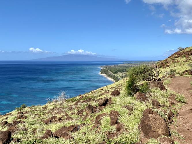
Lanai & Ocean View - Mile 0.44
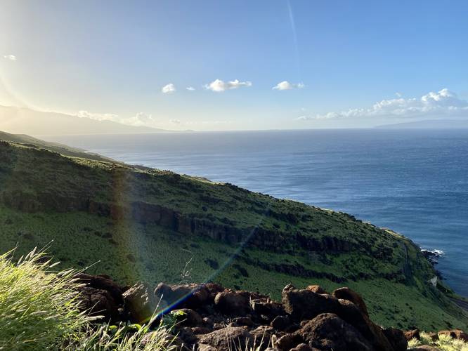
Around mile 0.44, if the hiker turns around (or you can catch it on the hike back), there's a beautiful view of Lanai in the distance with Ukumehame beach below.
Kamaohi Gulch Vista - Mile 0.65
Around mile 0.65, hikers will reach a nice view above the Kamaohi Gulch. Just beyond, around mile 0.8, they'll cross the gulch.
Gulch Crossings
Hikers will cross the following gulches at their respective mile markers: Mokumana Gulch - Mile 1.2, Opunaha Gulch - Mile 1.6, Makahuna Gulch - Mile 1.73, Kaalaina Gulch - Mile 1.8, Manawainui Gulch - Mile 2.1.
Shark Fin Rock - Mile 1.66
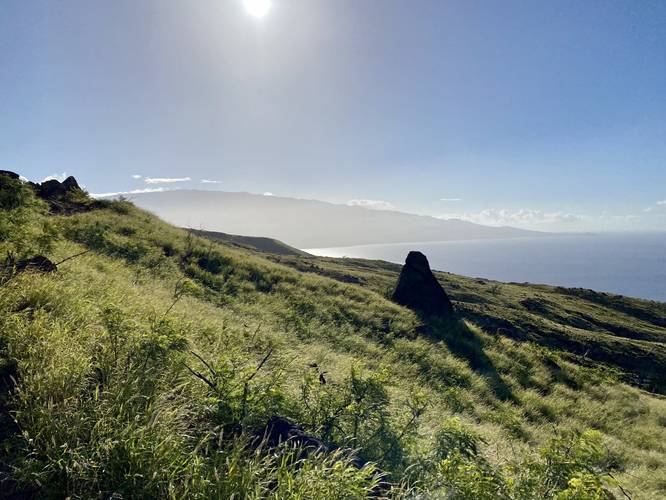
At mile 1.66, hikers will pass by Shark Fin Rock, which looks like the top fin of a shark, hence the name. Looking east, you get a nice view of Haleakala's western slopes in the background.
Manawainui Gulch - Mile 2.1
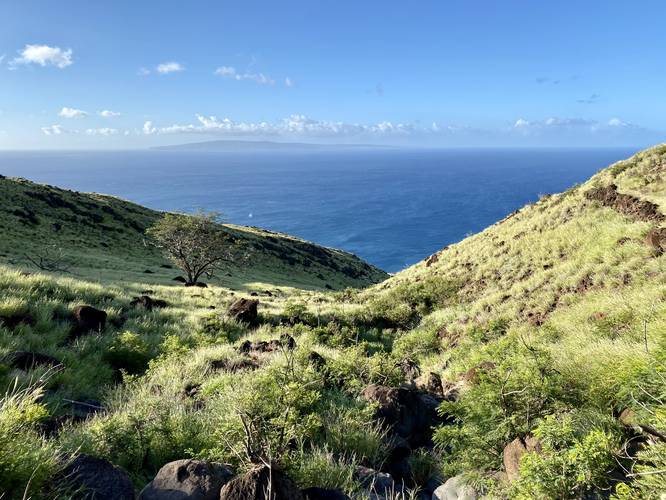
At mile 2.1 hikers will reach the Manawainui Gulch which provides a deep-cut canyon view facing south toward the ocean. This gulch has steep canyon ridges which provides a unique experience. From here, the trail heads back up the mountain from the gulch to reach the ridge and wind turbines. This is the last ascent along the trail if you plan to turn around at the wind turbines.
Wind Turbines & Maui Valley Vista - Mile 2.9
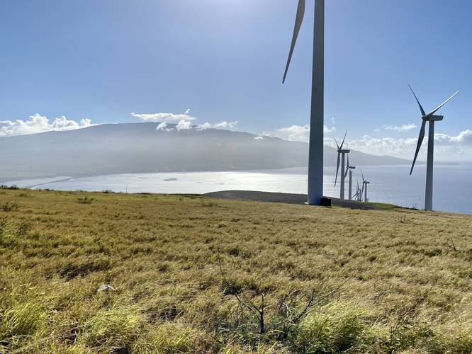
Around mile 2.9, hikers will reach the mountain ridge that, as of February 2023, features large wind turbines. This windy mountain ridge was a perfect place for the turbines, but that also means this spot is generally pretty windy. Upon our visit, the winds were around 20-30MPH. The view from the ridge vista is stunning - hikers peer into Maui's central valley, have a better view of the western slopes of Haleakala, and can see down the entire southern Maui coastline. The wind turbines are an additional neat feature.
Views - Miles 0.2 to 2.9
Due to the open terrain of this trail, from approx. mile 0.2 to the wind turbines located at mile 2.9, hikers will get views of Kaho'olawe island, Lanai, Molokini Crater, the western slopes of Haleakala, blue and turquoise-colored ocean water with coral far below your feet, canyon-like gulches, and finally the Maui valley from the wind turbine ridge.
Hiking Out
If you choose to hike this as and out-and-back and use the turbines as a turn-around spot, the hike back is easier and quicker than the hike up, with one exception - the rocky terrain takes a toll. The last half-mile of the hike out, closest to the parking lot, is where the rocks become extra annoying.
Parking
Hikers will find a large parking lot at the coordinates provided. The lot is large enough to fit just over 1-dozen vehicles. This parking lot fills up, as of February 2023, by 10:30AM on weekdays.
Pets
Dogs are allowed if leashed and their waste must be carried out by the hiker.
Difficulty
This trail should be considered moderate, but some hikers may find it "Hard" or difficult.
Warnings
Rocky terrain: This hike follows very rocky terrain for the majority of the hike. Note that it's best to wear hiking boots and possibly bring trekking poles to help. Heading downhill is fairly easy until the last half-mile or so, as this section is the worst to navigate with regard to rocks.
Steep Gulches: This trail follows some fairly-steep gulch canyonsides; however, none are very dangerous due to the wide trail.
Lack of Shade: Most of this trail is exposed to the sun with very few places to catch shade. It's best to hike this trail when the UV index is lower. Wear sunscreen and other skin protection to guard against the intense Hawaiian sun.
Extreme Fire Hazard: During dry seasons, this trail and thus the surrounding vegetation is extremely dry.
Flash Floods: Heavy rains in the mountains upstream can cause flash flooding. It's best to keep an eye on the weather and radar maps (see map Layers) to ensure the gulches are not full of water.
History
This trail is the old footpath and horse route that people once used over a century ago to connect Lahaina to Wailuku. During prehistoric times, people used to walk to this spot from Olowalu and had to choose to either swim, get help from a neighbor with a canoe, or climb the steep Kealaloloa Ridge to get to Ma'alaea. During missionary times, a road was built along this mountainside to accommodate horse and foot travel - eventually leading to carriages and cars. That road was abandoned, but hikers will travel on it from just up the trail from the trailhead to around mile 0.1. This old road is full of potholes, so watch your step.
Respecting the Land
Hawaiian land is considered sacred to native Hawaiians and many locals, so please stay on-trail, take nothing but photos, and leave nothing but footprints. Respect the locals - don't stay for long and have a backup hike planned in case the parking lot is full.
Hike Description
This hike begins at the western trailhead for the Lahaina Pali Trail which is by far the more popular trailhead. Most folks will hike up to the wind turbines along the mountain ridge and then hike back down as an out-and-back; however, if you have a shuttle, one can thru-hike this trail at a similar mileage, but you need a car or schedule a pickup at the eastern trailhead.
From the western trailhead, hikers will pass a couple of historical information signs at the trailhead before heading into the rock-filled trail. Just a couple-hundred feet into the hike, the trail will begin to follow an old paved road that's now littered with potholes.
Left-Hand Turn - Mile 0.15
At mile 0.15, hikers will head up a rocky hillside from the old road to continue following the Lahaina Pali Trail.
Lanai & Ocean View - Mile 0.44
Around mile 0.44, if the hiker turns around (or you can catch it on the hike back), there's a beautiful view of Lanai in the distance with Ukumehame beach below.
Kamaohi Gulch Vista - Mile 0.65
Around mile 0.65, hikers will reach a nice view above the Kamaohi Gulch. Just beyond, around mile 0.8, they'll cross the gulch.
Gulch Crossings
Hikers will cross the following gulches at their respective mile markers: Mokumana Gulch - Mile 1.2, Opunaha Gulch - Mile 1.6, Makahuna Gulch - Mile 1.73, Kaalaina Gulch - Mile 1.8, Manawainui Gulch - Mile 2.1.
Shark Fin Rock - Mile 1.66
At mile 1.66, hikers will pass by Shark Fin Rock, which looks like the top fin of a shark, hence the name. Looking east, you get a nice view of Haleakala's western slopes in the background.
Manawainui Gulch - Mile 2.1
At mile 2.1 hikers will reach the Manawainui Gulch which provides a deep-cut canyon view facing south toward the ocean. This gulch has steep canyon ridges which provides a unique experience. From here, the trail heads back up the mountain from the gulch to reach the ridge and wind turbines. This is the last ascent along the trail if you plan to turn around at the wind turbines.
Wind Turbines & Maui Valley Vista - Mile 2.9
Around mile 2.9, hikers will reach the mountain ridge that, as of February 2023, features large wind turbines. This windy mountain ridge was a perfect place for the turbines, but that also means this spot is generally pretty windy. Upon our visit, the winds were around 20-30MPH. The view from the ridge vista is stunning - hikers peer into Maui's central valley, have a better view of the western slopes of Haleakala, and can see down the entire southern Maui coastline. The wind turbines are an additional neat feature.
Views - Miles 0.2 to 2.9
Due to the open terrain of this trail, from approx. mile 0.2 to the wind turbines located at mile 2.9, hikers will get views of Kaho'olawe island, Lanai, Molokini Crater, the western slopes of Haleakala, blue and turquoise-colored ocean water with coral far below your feet, canyon-like gulches, and finally the Maui valley from the wind turbine ridge.
Hiking Out
If you choose to hike this as and out-and-back and use the turbines as a turn-around spot, the hike back is easier and quicker than the hike up, with one exception - the rocky terrain takes a toll. The last half-mile of the hike out, closest to the parking lot, is where the rocks become extra annoying.
Parking
Hikers will find a large parking lot at the coordinates provided. The lot is large enough to fit just over 1-dozen vehicles. This parking lot fills up, as of February 2023, by 10:30AM on weekdays.
Pets
Dogs are allowed if leashed and their waste must be carried out by the hiker.
Difficulty
This trail should be considered moderate, but some hikers may find it "Hard" or difficult.
Warnings
Rocky terrain: This hike follows very rocky terrain for the majority of the hike. Note that it's best to wear hiking boots and possibly bring trekking poles to help. Heading downhill is fairly easy until the last half-mile or so, as this section is the worst to navigate with regard to rocks.
Steep Gulches: This trail follows some fairly-steep gulch canyonsides; however, none are very dangerous due to the wide trail.
Lack of Shade: Most of this trail is exposed to the sun with very few places to catch shade. It's best to hike this trail when the UV index is lower. Wear sunscreen and other skin protection to guard against the intense Hawaiian sun.
Extreme Fire Hazard: During dry seasons, this trail and thus the surrounding vegetation is extremely dry.
Flash Floods: Heavy rains in the mountains upstream can cause flash flooding. It's best to keep an eye on the weather and radar maps (see map Layers) to ensure the gulches are not full of water.
History
This trail is the old footpath and horse route that people once used over a century ago to connect Lahaina to Wailuku. During prehistoric times, people used to walk to this spot from Olowalu and had to choose to either swim, get help from a neighbor with a canoe, or climb the steep Kealaloloa Ridge to get to Ma'alaea. During missionary times, a road was built along this mountainside to accommodate horse and foot travel - eventually leading to carriages and cars. That road was abandoned, but hikers will travel on it from just up the trail from the trailhead to around mile 0.1. This old road is full of potholes, so watch your step.
Respecting the Land
Hawaiian land is considered sacred to native Hawaiians and many locals, so please stay on-trail, take nothing but photos, and leave nothing but footprints. Respect the locals - don't stay for long and have a backup hike planned in case the parking lot is full.