The Kettle Hole Trail at Grover-Herrick Conservation Area in North Berwick, Maine is an easy 1-mile loop that leads to the edge of Bauneg Beg Pond, a Kettle Hole that was formed thousands of yeas ago by a receding glacier.
Hike Description
This trail begins at the small parking turnout and follows blue blazes in a loop. This recording follows the loop in a counter-clockwise direction by taking a right-hand turn first; however, the mileage to reach Bauneg Beg Pond is similar no matter which turn you take.
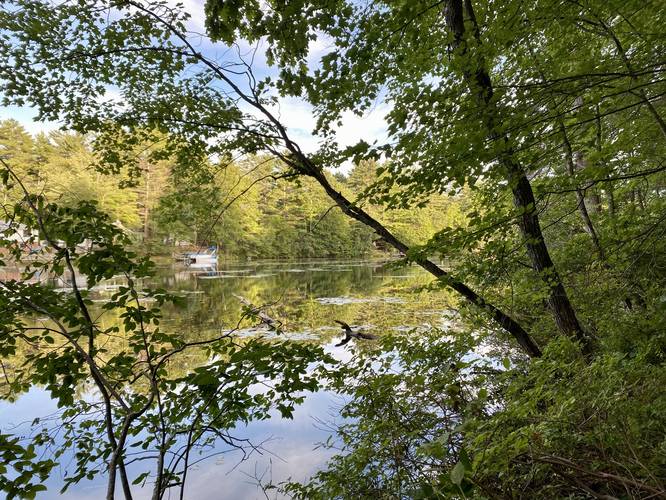
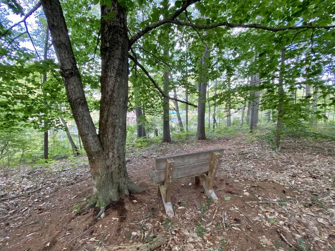
Bauneg Beg Pond View - Mile 0.38
Around mile 0.38, after hiking through an undulating forest, hikers will make their way out to an obstructed view (as of September 2022) of Bauneg Beg Pond. Bauneg Beg Pond is a Kettle Hole or Kettle Pond, which was formed by a receding glacier thousands of years ago. Just after the view of Bauneg Beg Pond is a bench where hikers can take a break or hang out, located around mile 0.42.
Wetlands - Miles 0.53 to 0.66
Between miles 0.53 and 0.66, hikers will pass wetland areas which provide bird watching opportunities, but also can be very buggy. We got a bit lucky with the bugs due to the Summer drought on this hike in 2022.
Hiking Out
After passing the wetland area, hikers will follow arrows and signage for parking to reach the trailhead for a 1-mile loop.
Parking
Hikers will find a very small parking turnout for the trailhead located at the coordinates provided. The turnout is large enough to fit 2, maybe 3 vehicles.
Pets
Dogs are allowed if leashed and their waste should be carried out by the hiker.
Warning
Bugs: This trail can be buggy especially during wet months since there's wetlands that surround sections of the trail, including Bauneg Beg Pond which can be home to many different types of biting insects.
What is a Kettle Hole?
A kettle hole is depression in an outwash plain that are formed from glaciers receding or from draining floodwaters. Kettle holes, created by glaciers, are generally formed when the glacier recedes and drops large chunks of ice called "dead ice". This dead ice lingers, but then becomes surrounded by sediment as meltwater streams from the glacier flow by. Over time, the ice becomes buried in the sediment and after it melts, it leaves a depression in the ground - forming a kettle hole or kettle pond.
Hike Description
This trail begins at the small parking turnout and follows blue blazes in a loop. This recording follows the loop in a counter-clockwise direction by taking a right-hand turn first; however, the mileage to reach Bauneg Beg Pond is similar no matter which turn you take.
Bauneg Beg Pond View - Mile 0.38
Around mile 0.38, after hiking through an undulating forest, hikers will make their way out to an obstructed view (as of September 2022) of Bauneg Beg Pond. Bauneg Beg Pond is a Kettle Hole or Kettle Pond, which was formed by a receding glacier thousands of years ago. Just after the view of Bauneg Beg Pond is a bench where hikers can take a break or hang out, located around mile 0.42.
Wetlands - Miles 0.53 to 0.66
Between miles 0.53 and 0.66, hikers will pass wetland areas which provide bird watching opportunities, but also can be very buggy. We got a bit lucky with the bugs due to the Summer drought on this hike in 2022.
Hiking Out
After passing the wetland area, hikers will follow arrows and signage for parking to reach the trailhead for a 1-mile loop.
Parking
Hikers will find a very small parking turnout for the trailhead located at the coordinates provided. The turnout is large enough to fit 2, maybe 3 vehicles.
Pets
Dogs are allowed if leashed and their waste should be carried out by the hiker.
Warning
Bugs: This trail can be buggy especially during wet months since there's wetlands that surround sections of the trail, including Bauneg Beg Pond which can be home to many different types of biting insects.
What is a Kettle Hole?
A kettle hole is depression in an outwash plain that are formed from glaciers receding or from draining floodwaters. Kettle holes, created by glaciers, are generally formed when the glacier recedes and drops large chunks of ice called "dead ice". This dead ice lingers, but then becomes surrounded by sediment as meltwater streams from the glacier flow by. Over time, the ice becomes buried in the sediment and after it melts, it leaves a depression in the ground - forming a kettle hole or kettle pond.