Keshequa Creek Falls Trail at Sonyea State Forest near Mount Morris, New York is an easy 2.8-mile out-and-back hike that features campsites and two waterfalls, Keshequa Creek Falls and an unnamed seasonal 30-foot waterfall.
Hike
This hike begins in the middle of Sonyea State Forest at the trailhead and parking coordinates provided and heads down the path gated by a yellow gate with a "stop" sign. The trail passes a roadside campsite located on the right-hand side as it begins to descend downhill toward Keshequa Creek. Along the way, hikers will enjoy a quiet and peaceful forest setting as the trail makes its way along the hillside. Around mile 0.35, hikers will find a steep, but short grade, that leads down to the flatland adjacent to the creek.
Campsite - Mile 0
At the trailhead is a first-come first-serve roadside campsite. Please be respectful to any campers you pass by.
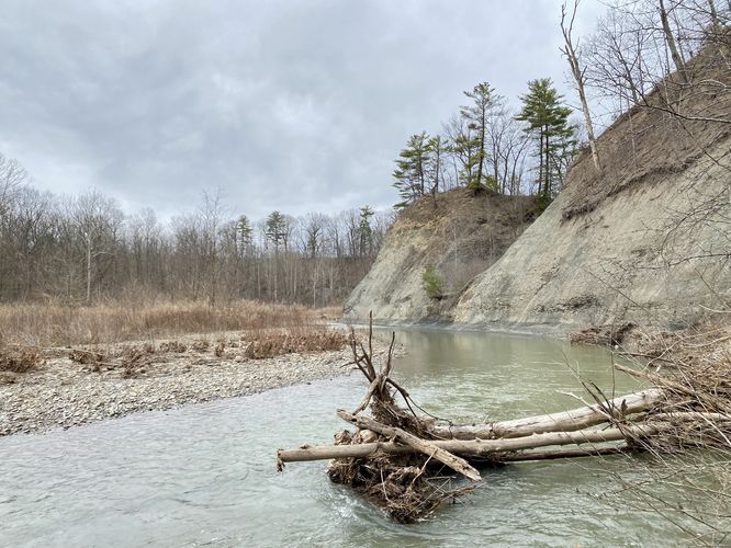
Keshequa Creek View - Mile 0.4
At mile 0.4, hikers will reach the first embankment of Keshequa Creek where you'll find scenic views of the creek and its super-steep rocky hillsides. This is a nice spot to take a quick break and enjoy the sights.
30-foot Multi-tiered Waterfall - Mile 0.8
Around mile 0.8, hikers will find an off-trail waterfall cascading down the bedrock of the hillside you just hiked down from - located to the southeast. This multi-tiered waterfall is about 30-feet tall from the top and appears to be seasonal. This waterfall may be dried up during the Summer, where as Keshequa Creek Falls flows year-round. This waterfall, despite being "more" scenic than Keshequa Creek Falls, is well-worth the stop, but it's not the last interesting point-of-interest on the hike, so this track continues onward.
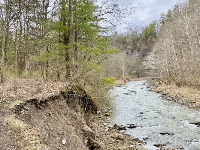
Shale Rock Ledges - Mile 0.85 & 1.15
Just beyond the 30-foot off-trail waterfall, hikers will find neat shale rock ledges that span a good portion of the trail's length. Here you'll find scree (loose rock/debris) that leads up to shale rock ledges. Some of these ledges reminded me of hiking around parts of Utah - the gray color, scree, and towering feeling are a neat addition to the walk here.
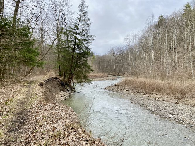
Erosion / Landslides - Mile 1 & 1.2
Hikers should be aware of the slightly-sketchy terrain of the trail near miles 1 and 1.2 -- here, the terrain near and on-trail has fallen into the creek via a landslide. You must be careful walking here and it's best to stay away from the edge as the soil can be very loose near the edge of the embankments.
Campsite - Mile 1.3
While not photographed or hiked-to in this GPS track, around mile 1.3 is another campsite that sits adjacent to Keshequa Creek.
Right-Hand Turn - Mile 1.45
Around mile 1.45 is a right-hand bend in the trail that follows a short but steep dip in the terrain before leading up and back down again. Take this right-hand turn and keep-right to head toward Keshequa Creek Falls (hint, you'll be able to hear it here).
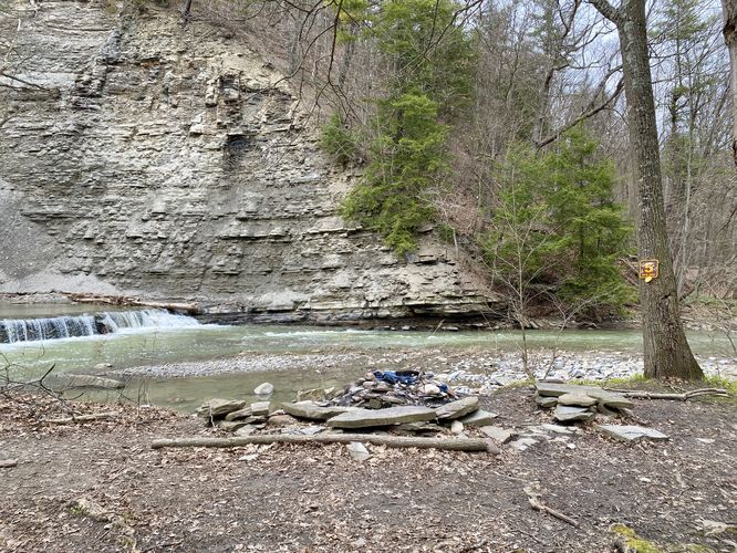
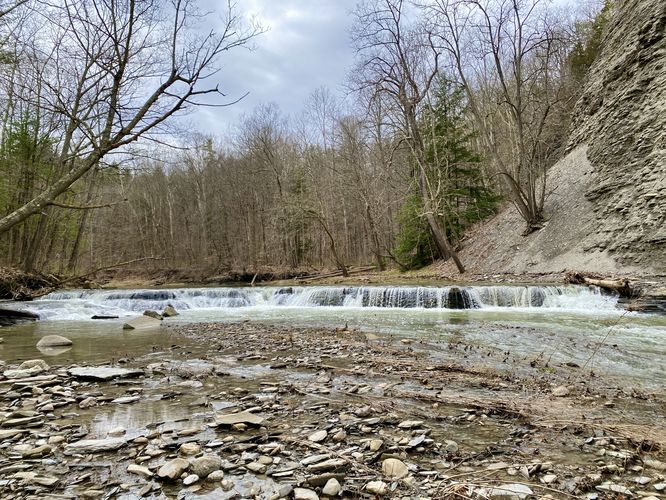
Keshequa Creek Falls & Campsite - Mile 1.5
At mile 1.5, hikers will reach a campsite that sits right next to Keshequa Creek Falls. Here you can either setup camp or hang out for a little while to enjoy the cascading water for a short but scenic day hike. Keshequa Creek Falls is no taller than 3-feet, but spans the entire creek, which is just over 100-feet wide. This short but scenic waterfall is well-worth the hike especially if you're looking to get away from the crowds at the nearby Letchworth State Park.
Hiking Out - Mile 1.5 to 2.9
The hike back to parking from Keshequa Creek Falls is slightly shorter than the hike in, due to skipping the off-trail waterfall on the hike in. The way out should be considered "easy" difficulty minus the short and steep moderate section of the trail where it ascends from the creek back up to the hillside. Most hikers will find the entire out-and-back of 2.9-miles easy.
Parking & How to Get There
Hikers will find a small parking turnout at the coordinates provided on the dirt, pothole-filled, Union Corners Road. Important: The trickiest part to getting to this parking lot is due to the fact that Google Maps (and likely other GPS apps) will try to send you down the forest road from the north; however, all of that land is private as it's run by a NY State correctional facility (it's a jail) -- you cannot drive down their roads despite Google Maps sending people there. You must drive to the entrance to Sonyea State Forest (42.657126, -77.841320), then drive north through the pothole-filled road to reach the parking turnout and the trailhead.
Biking
Biking is permitted along this trail as it is a multi-use/purpose trail.
Warning
Embankment erosion: As of April 2024, parts of this trail run adjacent to landslides that fell into the creek ~15 feet below. Due to the nature of landslides, the soil around affected areas might not be totally stable. Watch your footing and keep back from calved-off embankments for your own safety.
Hike
This hike begins in the middle of Sonyea State Forest at the trailhead and parking coordinates provided and heads down the path gated by a yellow gate with a "stop" sign. The trail passes a roadside campsite located on the right-hand side as it begins to descend downhill toward Keshequa Creek. Along the way, hikers will enjoy a quiet and peaceful forest setting as the trail makes its way along the hillside. Around mile 0.35, hikers will find a steep, but short grade, that leads down to the flatland adjacent to the creek.
Campsite - Mile 0
At the trailhead is a first-come first-serve roadside campsite. Please be respectful to any campers you pass by.
Keshequa Creek View - Mile 0.4
At mile 0.4, hikers will reach the first embankment of Keshequa Creek where you'll find scenic views of the creek and its super-steep rocky hillsides. This is a nice spot to take a quick break and enjoy the sights.
30-foot Multi-tiered Waterfall - Mile 0.8
Around mile 0.8, hikers will find an off-trail waterfall cascading down the bedrock of the hillside you just hiked down from - located to the southeast. This multi-tiered waterfall is about 30-feet tall from the top and appears to be seasonal. This waterfall may be dried up during the Summer, where as Keshequa Creek Falls flows year-round. This waterfall, despite being "more" scenic than Keshequa Creek Falls, is well-worth the stop, but it's not the last interesting point-of-interest on the hike, so this track continues onward.
Shale Rock Ledges - Mile 0.85 & 1.15
Just beyond the 30-foot off-trail waterfall, hikers will find neat shale rock ledges that span a good portion of the trail's length. Here you'll find scree (loose rock/debris) that leads up to shale rock ledges. Some of these ledges reminded me of hiking around parts of Utah - the gray color, scree, and towering feeling are a neat addition to the walk here.
Erosion / Landslides - Mile 1 & 1.2
Hikers should be aware of the slightly-sketchy terrain of the trail near miles 1 and 1.2 -- here, the terrain near and on-trail has fallen into the creek via a landslide. You must be careful walking here and it's best to stay away from the edge as the soil can be very loose near the edge of the embankments.
Campsite - Mile 1.3
While not photographed or hiked-to in this GPS track, around mile 1.3 is another campsite that sits adjacent to Keshequa Creek.
Right-Hand Turn - Mile 1.45
Around mile 1.45 is a right-hand bend in the trail that follows a short but steep dip in the terrain before leading up and back down again. Take this right-hand turn and keep-right to head toward Keshequa Creek Falls (hint, you'll be able to hear it here).
Keshequa Creek Falls & Campsite - Mile 1.5
At mile 1.5, hikers will reach a campsite that sits right next to Keshequa Creek Falls. Here you can either setup camp or hang out for a little while to enjoy the cascading water for a short but scenic day hike. Keshequa Creek Falls is no taller than 3-feet, but spans the entire creek, which is just over 100-feet wide. This short but scenic waterfall is well-worth the hike especially if you're looking to get away from the crowds at the nearby Letchworth State Park.
Hiking Out - Mile 1.5 to 2.9
The hike back to parking from Keshequa Creek Falls is slightly shorter than the hike in, due to skipping the off-trail waterfall on the hike in. The way out should be considered "easy" difficulty minus the short and steep moderate section of the trail where it ascends from the creek back up to the hillside. Most hikers will find the entire out-and-back of 2.9-miles easy.
Parking & How to Get There
Hikers will find a small parking turnout at the coordinates provided on the dirt, pothole-filled, Union Corners Road. Important: The trickiest part to getting to this parking lot is due to the fact that Google Maps (and likely other GPS apps) will try to send you down the forest road from the north; however, all of that land is private as it's run by a NY State correctional facility (it's a jail) -- you cannot drive down their roads despite Google Maps sending people there. You must drive to the entrance to Sonyea State Forest (42.657126, -77.841320), then drive north through the pothole-filled road to reach the parking turnout and the trailhead.
Biking
Biking is permitted along this trail as it is a multi-use/purpose trail.
Warning
Embankment erosion: As of April 2024, parts of this trail run adjacent to landslides that fell into the creek ~15 feet below. Due to the nature of landslides, the soil around affected areas might not be totally stable. Watch your footing and keep back from calved-off embankments for your own safety.