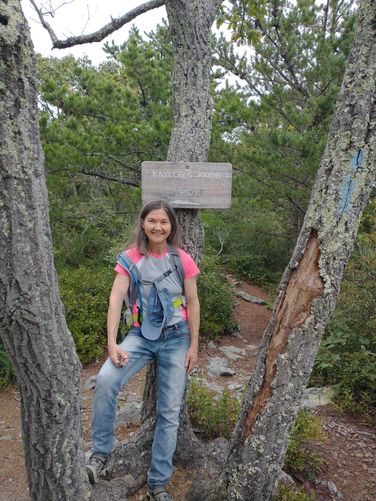
Trail names: Kaylor’s Knob Ridge Trail
Location: Del Webb Drive, McGaheysville, VA; George Washington National Forest.
Permitted uses: Hiking, Mountain Biking, Nature Study, Geocaching
Prohibited uses: No E Bikes Hours: Resort trails are closed during hunting season, from one hour before sunrise to one hour after sunset from Nov. 1 through Jan. 8, excluding Sundays.
Fees and Parking: There is no fee to park or use the trails
Pets: Dogs must be leashed at all times and owners must clean up after their pet.
Accessibility: This trail is not wheelchair accessible.
Hiker amenities: There is an information kiosk at the trailhead with a map. There are two trash bins at the trailhead parking area. There are no restrooms available.
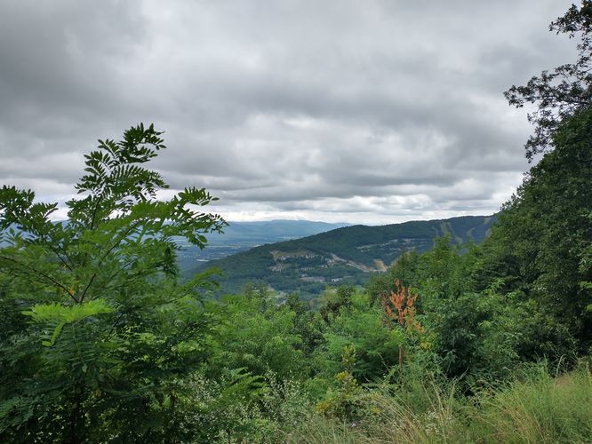
Length and Trail information: The hike is an out and back hike and is approximately 3.8 miles long. The trail is blazed by blue trail markers and heads northeast along the ridge of Massanutten Mountain. This trail system is part of the Shenandoah Valley Bicycle Coalition and hikers should be aware that they may encounter bikers along the trail. During our hike we encountered two. The hike is relatively easy with a small amount of elevation gain that is very gradual. There aren't long or overly steep sections along this trail, the only difficult part to this hike is navigating the amount of rocks that can be found along some areas. Hikers will want to wear appropriate footwear and pay attention while hiking through the rock scrambles to avoid falling. The rocky sections are not long in duration, in fact, there were a lot of flat sections on the trail that had either sandy substrate or substrate similar to walking on a bed of wood chips. Kaylor’s Knob Trail runs along a mountain ridge but the trail has plenty of wooded area on either side, so it will not feel as if there is danger of falling over the edge. Sadly, the amount of trees flanking the trail results in an obscuring of the view of the valley below. If hikers were able to hike in fall or early spring, views might be better due to lack of foliage. Only from time to time will there be vistas to see. However, when there is a clearing in the trees, the views are quite lovely. One thing we really enjoyed during this hike was the amount of different plants and trees that we were able to see beside the trail. So many were new to us, including American Chestnut, Sassafras, Bear Oak, Minniebush, Sawbrier, Turkey Beard, Table Mountain Pine, Deerberry and Carolina Rose. This was a nice hike that was better than we anticipated.
Location: Del Webb Drive, McGaheysville, VA; George Washington National Forest.
Permitted uses: Hiking, Mountain Biking, Nature Study, Geocaching
Prohibited uses: No E Bikes Hours: Resort trails are closed during hunting season, from one hour before sunrise to one hour after sunset from Nov. 1 through Jan. 8, excluding Sundays.
Fees and Parking: There is no fee to park or use the trails
Pets: Dogs must be leashed at all times and owners must clean up after their pet.
Accessibility: This trail is not wheelchair accessible.
Hiker amenities: There is an information kiosk at the trailhead with a map. There are two trash bins at the trailhead parking area. There are no restrooms available.
Length and Trail information: The hike is an out and back hike and is approximately 3.8 miles long. The trail is blazed by blue trail markers and heads northeast along the ridge of Massanutten Mountain. This trail system is part of the Shenandoah Valley Bicycle Coalition and hikers should be aware that they may encounter bikers along the trail. During our hike we encountered two. The hike is relatively easy with a small amount of elevation gain that is very gradual. There aren't long or overly steep sections along this trail, the only difficult part to this hike is navigating the amount of rocks that can be found along some areas. Hikers will want to wear appropriate footwear and pay attention while hiking through the rock scrambles to avoid falling. The rocky sections are not long in duration, in fact, there were a lot of flat sections on the trail that had either sandy substrate or substrate similar to walking on a bed of wood chips. Kaylor’s Knob Trail runs along a mountain ridge but the trail has plenty of wooded area on either side, so it will not feel as if there is danger of falling over the edge. Sadly, the amount of trees flanking the trail results in an obscuring of the view of the valley below. If hikers were able to hike in fall or early spring, views might be better due to lack of foliage. Only from time to time will there be vistas to see. However, when there is a clearing in the trees, the views are quite lovely. One thing we really enjoyed during this hike was the amount of different plants and trees that we were able to see beside the trail. So many were new to us, including American Chestnut, Sassafras, Bear Oak, Minniebush, Sawbrier, Turkey Beard, Table Mountain Pine, Deerberry and Carolina Rose. This was a nice hike that was better than we anticipated.