The Katy Jane Trail at Rider Park in Trout Run, Pennsylvania is a moderate 2.9-mile loop trail that leads to two stunning vista points - Katy Jane East Vista and the Katy Jane West Vista - along with a seasonal Winter Vista called Sunset Point.
The trailhead can be found just south of the parking area at the main parking lot at Rider Park. This trail follows yellow dot blazes and some regular yellow paint rectangle blazes - the blazes are easy to follow. The hike starts off heading clockwise around the loop, by first ascending Katy Jane Mountain, which is not the easiest hike for everyone.
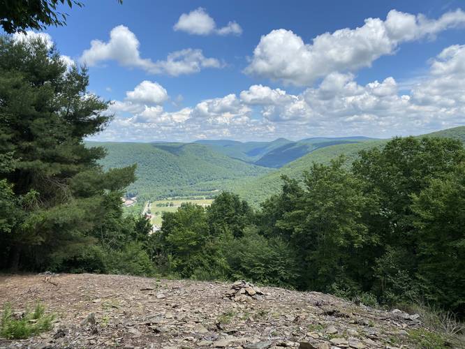
Katy Jane East Vista
After approximately 0.7-miles, hikers will reach the first vista point along the trail - Katy Jane East Vista. Here, you can take in stunning views heading eastward looking down the Loyalsock Creek Gorge. The noticeable sights here are the Allegheny Mountains which mark the edge of the Allegheny Plateau to your right-hand side, Smith Knob straight ahead down the gorge, and Wallis Run to your left-hand side.
After taking in the views at the Katy Jane East Vista, the remainder of the hike is much easier than the initial climb since the trail follows the Katy Jane Mountain ridge.
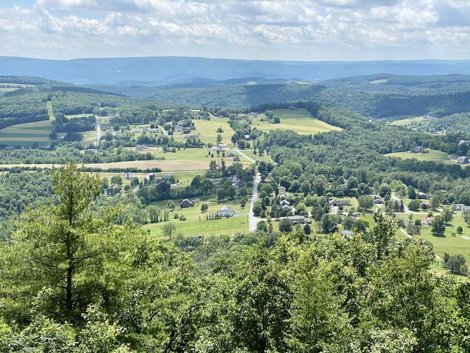
Katy Jane West Vista
Not long after hiking along the mostly-flat Katy Jane Mountain ridge, hikers will come across the second vista point - the Katy Jane West Vista. This stunning vista point gives hikers a view of Loyalsock Creek, farm lands within the valley below, and mountains in the distance - including Bald Eagle Mountain.
Around mile 1.27, hikers will reach a junction with the Saddle Trail (red blazes), which bisects this trail making for a shorter loop hike if desired. Continuing west along the Katy Jane Trail from here will have a slight amount of elevation gain before the trail flattens out once again before its descent.
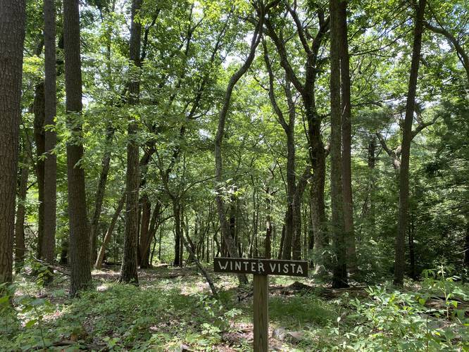
Sunset Point (Winter Vista)
The last vista and point of interest along this trail is a seasonal vista named Sunset Point, only worth checking out during the winter.
After visiting Sunset Point, the remainder of the hike is downhill and easy hiking. Follow the yellow blazes to reach the parking lot.
Difficulty
Hiking this trail in a clockwise direction, as shown in the data provided, will be a more difficult hike than counterclockwise; hence the difficulty rating is Moderate.
Parking
Hikers will find a large parking lot at the coordinates provided - large enough to fit about dozen cars. Just down the road, as you drive in, there will be an equally-sized parking lot about 100-feet away as well.
History
Katy Jane Mountain has been long associated with the Underground Railroad, which was a secret network of individuals, routes and safe shelters that helped people escape slavery before the Civil War. It's not entirely clear who Katy Jane was - some say she was an escaped slave who climbed the mountain each night holding lanterns to signal to other runaways if it was safe to cross Loyalsock Creek or if slave catchers were in pursuit. Others say that Katy Jane was Katy Jane Chapman, a Quaker woman whose home was at the base of the mountain. She may have left some of the escaping slaves over the old stagecoach road to Trout Run, where they were hidden on baggage cars northbound on the Williamsport-Elmira Railroad.
Facilities
There is a portable-toilet at the trailhead, but there are no running water restrooms available.
Pets
Dogs are allowed if leashed.
Biking
Biking is permitted along this trail and the other trails at Rider Park.
The trailhead can be found just south of the parking area at the main parking lot at Rider Park. This trail follows yellow dot blazes and some regular yellow paint rectangle blazes - the blazes are easy to follow. The hike starts off heading clockwise around the loop, by first ascending Katy Jane Mountain, which is not the easiest hike for everyone.
Katy Jane East Vista
After approximately 0.7-miles, hikers will reach the first vista point along the trail - Katy Jane East Vista. Here, you can take in stunning views heading eastward looking down the Loyalsock Creek Gorge. The noticeable sights here are the Allegheny Mountains which mark the edge of the Allegheny Plateau to your right-hand side, Smith Knob straight ahead down the gorge, and Wallis Run to your left-hand side.
After taking in the views at the Katy Jane East Vista, the remainder of the hike is much easier than the initial climb since the trail follows the Katy Jane Mountain ridge.
Katy Jane West Vista
Not long after hiking along the mostly-flat Katy Jane Mountain ridge, hikers will come across the second vista point - the Katy Jane West Vista. This stunning vista point gives hikers a view of Loyalsock Creek, farm lands within the valley below, and mountains in the distance - including Bald Eagle Mountain.
Around mile 1.27, hikers will reach a junction with the Saddle Trail (red blazes), which bisects this trail making for a shorter loop hike if desired. Continuing west along the Katy Jane Trail from here will have a slight amount of elevation gain before the trail flattens out once again before its descent.
Sunset Point (Winter Vista)
The last vista and point of interest along this trail is a seasonal vista named Sunset Point, only worth checking out during the winter.
After visiting Sunset Point, the remainder of the hike is downhill and easy hiking. Follow the yellow blazes to reach the parking lot.
Difficulty
Hiking this trail in a clockwise direction, as shown in the data provided, will be a more difficult hike than counterclockwise; hence the difficulty rating is Moderate.
Parking
Hikers will find a large parking lot at the coordinates provided - large enough to fit about dozen cars. Just down the road, as you drive in, there will be an equally-sized parking lot about 100-feet away as well.
History
Katy Jane Mountain has been long associated with the Underground Railroad, which was a secret network of individuals, routes and safe shelters that helped people escape slavery before the Civil War. It's not entirely clear who Katy Jane was - some say she was an escaped slave who climbed the mountain each night holding lanterns to signal to other runaways if it was safe to cross Loyalsock Creek or if slave catchers were in pursuit. Others say that Katy Jane was Katy Jane Chapman, a Quaker woman whose home was at the base of the mountain. She may have left some of the escaping slaves over the old stagecoach road to Trout Run, where they were hidden on baggage cars northbound on the Williamsport-Elmira Railroad.
Facilities
There is a portable-toilet at the trailhead, but there are no running water restrooms available.
Pets
Dogs are allowed if leashed.
Biking
Biking is permitted along this trail and the other trails at Rider Park.