Kapa'a Falls via Ho'opi'i Falls Trail in Kapa'a, Hawaii (Kauai) is a moderate 0.9-mile out-and-back trail that leads to Kapa'a Falls and the popular Ho'opi'i Falls downstream which are both considered waterfall swimming holes. Please note that this track ends at the first waterfall, nicknamed Kapa'a Falls, and does not reach Ho'opi'i Falls which is about 1.5-mile or more from the parking area which would be a 3-mile out-and-back hike for those who want to reach it.
Hike Description
This hike begins along Kapahi Road and follows a jungle-like trail downhill as it then begins to follow the Kapa'a Stream. Hikers may find two different trailhead locations for this hike, but both locations are not far apart from one another - look for metal cans on the ground (as of June 2022) so that you don't hit your feet on whatever is sticking out of there (maybe old stumps or metal pipes).
Once the trail reaches the Kapa'a Stream, hikers may notice the sunlight trickling in through the forests' canopy, which is a beautiful sight to watch as the steam's water passes by underneath within this lush jungle-like forest. As you continue hiking the trail, you may notice wild Bird of Paradise plants, likely flowering, just off-trail.
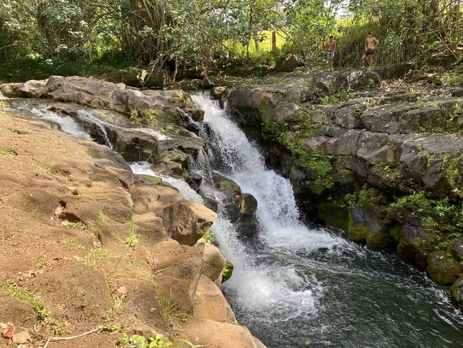
Kapa'a Falls (15-feet tall) - Mile 0.5
Just before reaching Kapa'a Falls, hikers will notice a steep trail that leads down to the sound of rushing water - this is your turn to reach Kapa'a Falls and its swimming hole. At mile 0.5, hikers will reach the waterfall, which is can be found displayed as a twin waterfall with two cascades that spill down the bedrock. Kapa'a Falls is about 15-feet tall and appears to have a swimming hole, due to the folks jumping in. For anyone looking to jump into the swimming hole, it's best to always check the underwater terrain before jumping because flash floods, storms, and erosion can cause the topography to change - there may be a newly-placed boulder sitting in what used to be a "safe" jumping location. Always use precaution and check the swimming hole's jump locations before attempting, or just don't jump in.
Hike Out or Continue
This track ends at Kapa'a Falls because we didn't bring bug spray and the mosquitos here were pretty nasty. Ho'opi'i Falls can be found downstream and is the main focus of this hike for most people; however the pictures available online don't necessarily make that waterfall seem any more or less interesting than Kapa'a Falls. Choose your pick and check out both if you wish. The hike out from Kapa'a Falls is not that difficult, but is moderate nonetheless as the hiker has to go back uphill along, sometimes, slippery terrain.
Parking
This trailhead has no true parking lot; however, visitors will find parking turnouts near the trailhead along Kapahi Road which is public. The parking turnouts are large enough to fit a compact or standard-sized vehicle just off of the road on the western/northern side. If you show up and there's no parking available, please find another place to go and come back another time so that you don't bother the locals and general public. There's enough parking for maybe 10 vehicles, from what it looked like.
Warnings
Flash Floods: These streams experience flash flooding randomly and at odd times. Hikers, visitors, and swimmers, should pay attention to upstream weather before deciding to head here. Pay attention to your surroundings and listen to nature. If you have cell service, it's best to check the weather from time to time in both your current location and somewhere upstream.
Swimming Holes: This hike leads to swimming holes that may or may not have changed since the last time someone successfully jumped in. As stated above, flash floods can happen any time, and these often change the topography, terrain, and landscape below the waterfalls and within these swimming holes. If you plan to jump in, always check under the water before doing so - make sure the area is deep enough and without any obstructions below. You do not want to be rescued here or potentially die just because you wanted to jump into a waterfall swimming hole.
Bugs: This trail has a lot of mosquitos despite the constant moving water of Kapa'a Stream. It's best to bring bug spray unless you want to get eaten alive. Upon this trip, we were only able to handle the mosquitos for Kapa'a Falls, but then turned back.
Respecting the Land
Hawaiian land is considered sacred to native Hawaiians and many locals, so please stay on-trail, take nothing but photos, and leave nothing but footprints. Respect the locals - don't stay for long and have a backup hike planned in case the parking lot is full.
Hike Description
This hike begins along Kapahi Road and follows a jungle-like trail downhill as it then begins to follow the Kapa'a Stream. Hikers may find two different trailhead locations for this hike, but both locations are not far apart from one another - look for metal cans on the ground (as of June 2022) so that you don't hit your feet on whatever is sticking out of there (maybe old stumps or metal pipes).
Once the trail reaches the Kapa'a Stream, hikers may notice the sunlight trickling in through the forests' canopy, which is a beautiful sight to watch as the steam's water passes by underneath within this lush jungle-like forest. As you continue hiking the trail, you may notice wild Bird of Paradise plants, likely flowering, just off-trail.
Kapa'a Falls (15-feet tall) - Mile 0.5
Just before reaching Kapa'a Falls, hikers will notice a steep trail that leads down to the sound of rushing water - this is your turn to reach Kapa'a Falls and its swimming hole. At mile 0.5, hikers will reach the waterfall, which is can be found displayed as a twin waterfall with two cascades that spill down the bedrock. Kapa'a Falls is about 15-feet tall and appears to have a swimming hole, due to the folks jumping in. For anyone looking to jump into the swimming hole, it's best to always check the underwater terrain before jumping because flash floods, storms, and erosion can cause the topography to change - there may be a newly-placed boulder sitting in what used to be a "safe" jumping location. Always use precaution and check the swimming hole's jump locations before attempting, or just don't jump in.
Hike Out or Continue
This track ends at Kapa'a Falls because we didn't bring bug spray and the mosquitos here were pretty nasty. Ho'opi'i Falls can be found downstream and is the main focus of this hike for most people; however the pictures available online don't necessarily make that waterfall seem any more or less interesting than Kapa'a Falls. Choose your pick and check out both if you wish. The hike out from Kapa'a Falls is not that difficult, but is moderate nonetheless as the hiker has to go back uphill along, sometimes, slippery terrain.
Parking
This trailhead has no true parking lot; however, visitors will find parking turnouts near the trailhead along Kapahi Road which is public. The parking turnouts are large enough to fit a compact or standard-sized vehicle just off of the road on the western/northern side. If you show up and there's no parking available, please find another place to go and come back another time so that you don't bother the locals and general public. There's enough parking for maybe 10 vehicles, from what it looked like.
Warnings
Flash Floods: These streams experience flash flooding randomly and at odd times. Hikers, visitors, and swimmers, should pay attention to upstream weather before deciding to head here. Pay attention to your surroundings and listen to nature. If you have cell service, it's best to check the weather from time to time in both your current location and somewhere upstream.
Swimming Holes: This hike leads to swimming holes that may or may not have changed since the last time someone successfully jumped in. As stated above, flash floods can happen any time, and these often change the topography, terrain, and landscape below the waterfalls and within these swimming holes. If you plan to jump in, always check under the water before doing so - make sure the area is deep enough and without any obstructions below. You do not want to be rescued here or potentially die just because you wanted to jump into a waterfall swimming hole.
Bugs: This trail has a lot of mosquitos despite the constant moving water of Kapa'a Stream. It's best to bring bug spray unless you want to get eaten alive. Upon this trip, we were only able to handle the mosquitos for Kapa'a Falls, but then turned back.
Respecting the Land
Hawaiian land is considered sacred to native Hawaiians and many locals, so please stay on-trail, take nothing but photos, and leave nothing but footprints. Respect the locals - don't stay for long and have a backup hike planned in case the parking lot is full.