The Kaaterskill Falls Trail at Catskill Park near Haines Falls,
New York is a strenuous 1.8-mile out-and-back
ultra-popular hike that leads to the 230-foot tall
waterfall, Kaaterskill Falls.
Trails
This hike follows two named trails: Escarpment Trail, Kaaterskill Falls Trail.
Universal Accessibility
Note that this hike follows a short universally accessible path that leads to an overlook at the top of Kaaterskill Falls. For visitors who do not wish or cannot complete this strenuous hike, consider reading our Kaaterskill Falls Overlook Trail guide.
Hike Description
This hike begins at the main parking lot for Kaaterskill Falls and follows the crushed stone path down the hill at a gradual grade. Hikers will follow signs for Kaaterskill Falls first, then follow signs for the overlook, if they wish to explore that first. Along the hike in, you'll find a beautiful stand of pine trees that lines the gravel trail.
Kaaterskill Falls Overlook - Mile 0.3
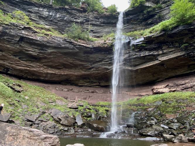
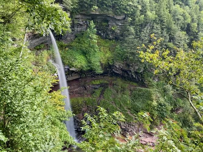
At mile 0.3, hikers will reach the overlook for Kaaterskill Falls where you'll find a viewing platform at the end of the universally-accessible trail. Here, you can enjoy the upper tier of the 230-foot tall waterfall known as Kaaterskill Falls. This upper tier of the waterfall makes up for the majority of the total height; however, the lower falls section (which appeared to be about 80-feet tall, approximately) is not visible from this platform.
Top of Kaaterskill Falls - Mile 0.4
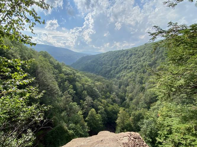
From the overlook, hikers can follow the dirt trail behind the information kiosk to follow a trail that leads to a canyon overlook and the top of Kaaterskill Falls. At the top of the waterfall, you'll find a plethora of names and dates carved into the bedrock - the oldest we found on our hike was 1825. The views of the canyon and the top of the waterfall are pretty stunning, but only sets the stage for the best views from below.
Hiking down to Kaaterskill Falls - Mile 0.4 to 1
From the top of Kaaterskill Falls, hikers will head back to the main trail to follow it northeastward to meet up once again with a universally-accessible path, located near where you first turned to reach the overlook. Hikers will head across the footbridge and then take a right-hand turn to follow the path that leads down to Kaaterskill Falls. Note that there's another right-hand turn around mile 0.65 (in the data provided) where the hiker will leave the Escarpment Trail to hop on the Kaaterskill Falls Trail. The Kaaterskill Falls trail's strenuous difficulty begins around this turn because of the sheer elevation change and series of steps to reach the waterfall. Hikers will head down a countless amount of steps to reach, first, the ledge trail that leads to Upper Falls, but also more stairs that lead down to Lower Falls. Following the stairs all the way to the bottom will provide hikers will one of the best views of Kaaterskill Falls, located around mile 1.
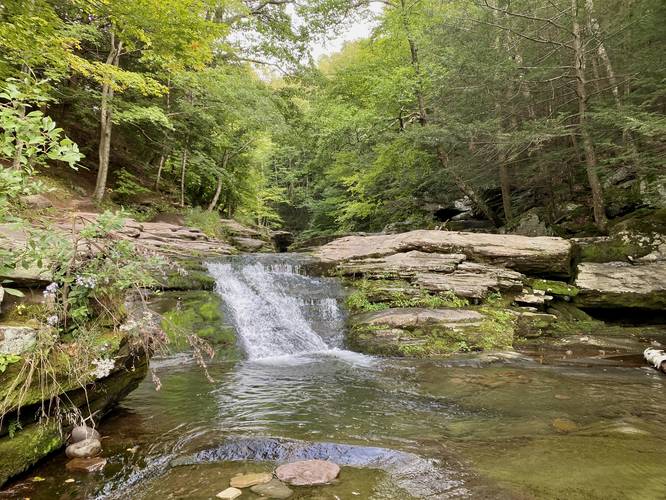
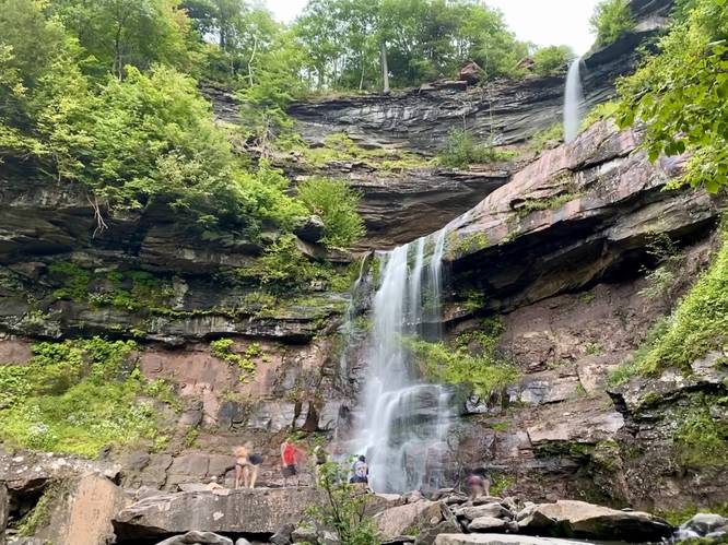
Lower Falls Base
Not included in the GPS data despite scrambling over to it, hikers can enjoy the base of Lower Kaaterskill Falls by scrambling up and around the rocks and canyon sides to reach the waterfall. Many people will hop into the pool of water below during Summer months, hence, this is a popular swimming hole.
Upper Kaaterskill Falls / Ledge Trail - Mile 1.1
After exploring the lower falls portion of Kaaterskill Falls, hikers will want to explore the Upper Falls portion. At mile 1.1, or located on your way down, is an off-shoot trail that follows a cliff ledge (with a railing) that leads to the Upper Falls portion of Kaaterskill Falls. Upper Falls is the tallest free-falling cascade within the waterfall and makes up for the majority of the 230-feet of falling water. Upper Falls also includes another swimming hole, that during Summer months, is another popular spot to find people cooling off in the water.
Hiking Out - Mile 1.2 to 1.8
From Upper Falls, starting around mile 1.2, hikers will start the strenuous hike back up and out of the canyon - following the same route you hiked in on. Take your time as you tackle the endless staircase back. Once at the footbridge, keep right to head back to the parking lot.
Parking
Hikers will find a large parking lot at the coordinates provided, large enough to fit a couple dozen vehicles. The lot fills up quickly, especially on holiday weekends, as this is one of the most popular hiking destinations in the Hudson Valley.
Pets
Dogs are allowed if leashed and must be cleaned up after the hiker.
Popularity
This is one of the most popular hikes in and around the Hudson Valley, so plan to show up very early or later in the day - closer to dinner - to enjoy smaller crowds. Holiday weekends are especially busy here.
Swimming Holes
Kaaterskill Falls is a popular swimming hole during Summer months as both the Lower and Upper Falls provide a spot for hikers and tourists to cool off.
Warning
Steep ledges: This hike includes steep ledges, so hikers should be mindful of where they walk.
Scrambling: There's a bit of rock scrambling required to reach the best views from the base of lower Kaaterskill Falls.
Trails
This hike follows two named trails: Escarpment Trail, Kaaterskill Falls Trail.
Universal Accessibility
Note that this hike follows a short universally accessible path that leads to an overlook at the top of Kaaterskill Falls. For visitors who do not wish or cannot complete this strenuous hike, consider reading our Kaaterskill Falls Overlook Trail guide.
Hike Description
This hike begins at the main parking lot for Kaaterskill Falls and follows the crushed stone path down the hill at a gradual grade. Hikers will follow signs for Kaaterskill Falls first, then follow signs for the overlook, if they wish to explore that first. Along the hike in, you'll find a beautiful stand of pine trees that lines the gravel trail.
Kaaterskill Falls Overlook - Mile 0.3
At mile 0.3, hikers will reach the overlook for Kaaterskill Falls where you'll find a viewing platform at the end of the universally-accessible trail. Here, you can enjoy the upper tier of the 230-foot tall waterfall known as Kaaterskill Falls. This upper tier of the waterfall makes up for the majority of the total height; however, the lower falls section (which appeared to be about 80-feet tall, approximately) is not visible from this platform.
Top of Kaaterskill Falls - Mile 0.4
From the overlook, hikers can follow the dirt trail behind the information kiosk to follow a trail that leads to a canyon overlook and the top of Kaaterskill Falls. At the top of the waterfall, you'll find a plethora of names and dates carved into the bedrock - the oldest we found on our hike was 1825. The views of the canyon and the top of the waterfall are pretty stunning, but only sets the stage for the best views from below.
Hiking down to Kaaterskill Falls - Mile 0.4 to 1
From the top of Kaaterskill Falls, hikers will head back to the main trail to follow it northeastward to meet up once again with a universally-accessible path, located near where you first turned to reach the overlook. Hikers will head across the footbridge and then take a right-hand turn to follow the path that leads down to Kaaterskill Falls. Note that there's another right-hand turn around mile 0.65 (in the data provided) where the hiker will leave the Escarpment Trail to hop on the Kaaterskill Falls Trail. The Kaaterskill Falls trail's strenuous difficulty begins around this turn because of the sheer elevation change and series of steps to reach the waterfall. Hikers will head down a countless amount of steps to reach, first, the ledge trail that leads to Upper Falls, but also more stairs that lead down to Lower Falls. Following the stairs all the way to the bottom will provide hikers will one of the best views of Kaaterskill Falls, located around mile 1.
Lower Falls Base
Not included in the GPS data despite scrambling over to it, hikers can enjoy the base of Lower Kaaterskill Falls by scrambling up and around the rocks and canyon sides to reach the waterfall. Many people will hop into the pool of water below during Summer months, hence, this is a popular swimming hole.
Upper Kaaterskill Falls / Ledge Trail - Mile 1.1
After exploring the lower falls portion of Kaaterskill Falls, hikers will want to explore the Upper Falls portion. At mile 1.1, or located on your way down, is an off-shoot trail that follows a cliff ledge (with a railing) that leads to the Upper Falls portion of Kaaterskill Falls. Upper Falls is the tallest free-falling cascade within the waterfall and makes up for the majority of the 230-feet of falling water. Upper Falls also includes another swimming hole, that during Summer months, is another popular spot to find people cooling off in the water.
Hiking Out - Mile 1.2 to 1.8
From Upper Falls, starting around mile 1.2, hikers will start the strenuous hike back up and out of the canyon - following the same route you hiked in on. Take your time as you tackle the endless staircase back. Once at the footbridge, keep right to head back to the parking lot.
Parking
Hikers will find a large parking lot at the coordinates provided, large enough to fit a couple dozen vehicles. The lot fills up quickly, especially on holiday weekends, as this is one of the most popular hiking destinations in the Hudson Valley.
Pets
Dogs are allowed if leashed and must be cleaned up after the hiker.
Popularity
This is one of the most popular hikes in and around the Hudson Valley, so plan to show up very early or later in the day - closer to dinner - to enjoy smaller crowds. Holiday weekends are especially busy here.
Swimming Holes
Kaaterskill Falls is a popular swimming hole during Summer months as both the Lower and Upper Falls provide a spot for hikers and tourists to cool off.
Warning
Steep ledges: This hike includes steep ledges, so hikers should be mindful of where they walk.
Scrambling: There's a bit of rock scrambling required to reach the best views from the base of lower Kaaterskill Falls.