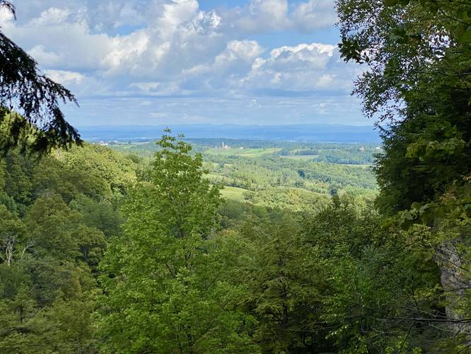
Judds Falls in Cherry Valley, New York is a moderate 1.1-mile out-and-back hike that leads to the 80-foot tall waterfall known as Judds Falls and features views of the rolling hills toward Fort Plain, NY.
Hike Description
This hike begins at the unmarked trailhead located at the parking coordinates provided - at the junction of Salt Springville Road and County Highway 32 (NY-166). The trailhead has no signage but there are several large boulders that keep cars from driving toward the woods here - that's the trailhead.
The trail leads into the woods without any signage, so hikers are left to guess where to go (unless you read this guide!).
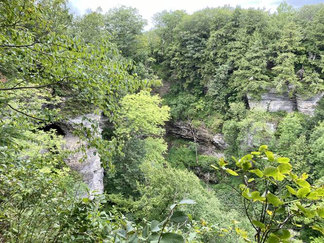
Cave & Canyon View - Mile 0.05
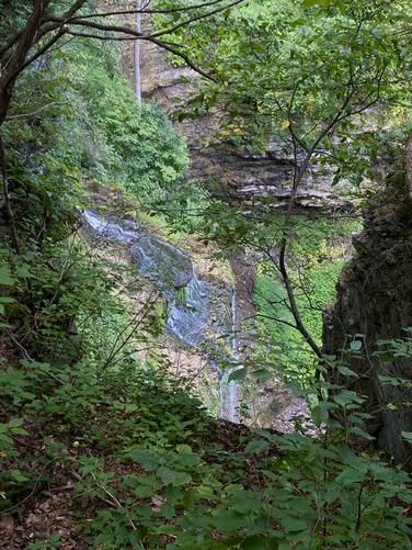
First, this GPS track will lead hikers to a canyon view downstream from Judds Falls. The trail will lead into the woods and the hiker will go straight and then head to the right-hand side toward the canyon to find this overlook. The overlook consists of the canyon and a neat old cave that sits on the side of the canyon. Note that we tried to get to the cave, but it appears as though it's only reachable via technical climbing.
Reaching Judds Falls - Mile 0.05 to 0.5
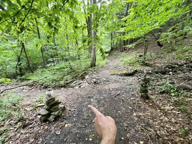
To reach Judds Falls, hikers can follow the main trail they came in on (turn around from the canyon view) and head northward. The trail will quickly begin heading down into the canyon along a gradual grade, passing a rock ledge along the way. Important note: you must take a left-hand turn to continue following the trail as it heads deeper into the canyon - if you miss this turn, you will not hike to Judds Falls!
Sketchy Hiking - Mile 0.4 to 0.5
The last 0.1 miles of the hike is a bit sketchy - not all that dangerous, but can be tricky with footing. The trail itself is skinny and there's a very large rockslide that you'll have to hike around/over to continue hiking upstream. The rocks are larger than fists, so they can roll your ankles pretty easily.
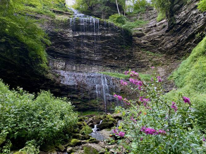
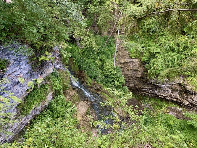
Judds Falls - Mile 0.5
Finally, after hiking down the canyon and over the rockslide, hikers will reach the ~80-foot tall Judds Falls as it cascades down into the gorge below. The waterfall is stunning and massive with huge gorge walls that surround you. Take in the scenery and take as many photos as you wish before leaving; however, your hike isn't over yet if you wish to explore the top of Judds Falls.
Hiking out of the gorge is not super difficult but takes a bit of time - plan on slightly slower hiking than usual and take your time hiking up and out. Once at the top again, hikers can explore the top of Judds Falls.
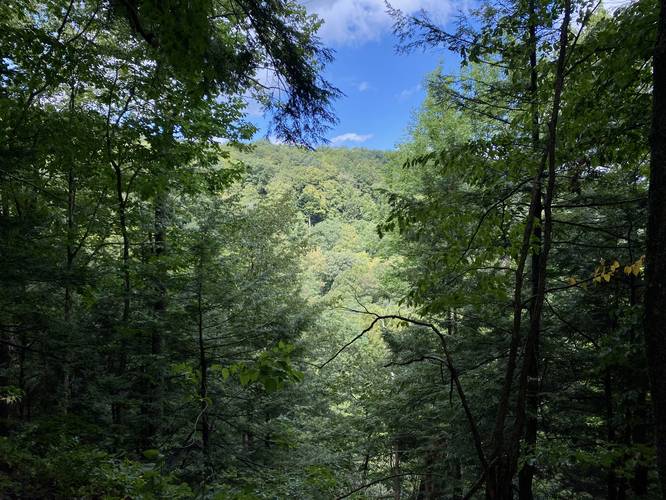
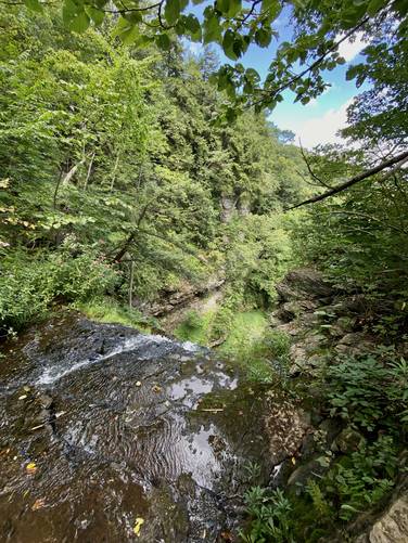
Top of Judds Falls and Views - Mile 0.9 to 1
From mile 0.9, located near the original turn you took on the way in, hikers can walk toward the top of Judds Falls which features at least two really nice views of the waterfall itself as it cascades down into the gorge. Additionally, there's a view toward Fort Plain, New York from the cliffs here. Last, if you follow the trail all the way out, it'll lead to the very top of Judds Falls with a view into the canyon.
Cave
Last note on the cave - there's a neat gorge-side cave adjacent to Judds Falls with a very large piece of sheet metal sitting on the cave's floor. It appears as though maybe a mining company carved something out of the rock long-ago; however, that's speculation. Hikers have literally no way of entering the cave (we checked), but you can view it from the 1st canyon overlook.
Parking
Hikers will find a small parking turnout at the coordinates provided, located at the parking coordinates provided - at the junction of Salt Springville Road and County Highway 32 (NY-166).
Pets
Dogs are allowed if leashed and should be cleaned up after.
Warnings
Steep terrain: This hike follows some extremely-steep terrain that, if you fall, could cause serious injury or worse. It's smart to keep back from the ledges assuming some could break-away at any time.
Falling rocks: This trail passes through steep canyon sections where rockslides have obviously happened in the past - sending tons of rock debris down into the canyon. Hike at your own risk.
Hike Description
This hike begins at the unmarked trailhead located at the parking coordinates provided - at the junction of Salt Springville Road and County Highway 32 (NY-166). The trailhead has no signage but there are several large boulders that keep cars from driving toward the woods here - that's the trailhead.
The trail leads into the woods without any signage, so hikers are left to guess where to go (unless you read this guide!).
Cave & Canyon View - Mile 0.05
First, this GPS track will lead hikers to a canyon view downstream from Judds Falls. The trail will lead into the woods and the hiker will go straight and then head to the right-hand side toward the canyon to find this overlook. The overlook consists of the canyon and a neat old cave that sits on the side of the canyon. Note that we tried to get to the cave, but it appears as though it's only reachable via technical climbing.
Reaching Judds Falls - Mile 0.05 to 0.5
To reach Judds Falls, hikers can follow the main trail they came in on (turn around from the canyon view) and head northward. The trail will quickly begin heading down into the canyon along a gradual grade, passing a rock ledge along the way. Important note: you must take a left-hand turn to continue following the trail as it heads deeper into the canyon - if you miss this turn, you will not hike to Judds Falls!
Sketchy Hiking - Mile 0.4 to 0.5
The last 0.1 miles of the hike is a bit sketchy - not all that dangerous, but can be tricky with footing. The trail itself is skinny and there's a very large rockslide that you'll have to hike around/over to continue hiking upstream. The rocks are larger than fists, so they can roll your ankles pretty easily.
Judds Falls - Mile 0.5
Finally, after hiking down the canyon and over the rockslide, hikers will reach the ~80-foot tall Judds Falls as it cascades down into the gorge below. The waterfall is stunning and massive with huge gorge walls that surround you. Take in the scenery and take as many photos as you wish before leaving; however, your hike isn't over yet if you wish to explore the top of Judds Falls.
Hiking out of the gorge is not super difficult but takes a bit of time - plan on slightly slower hiking than usual and take your time hiking up and out. Once at the top again, hikers can explore the top of Judds Falls.
Top of Judds Falls and Views - Mile 0.9 to 1
From mile 0.9, located near the original turn you took on the way in, hikers can walk toward the top of Judds Falls which features at least two really nice views of the waterfall itself as it cascades down into the gorge. Additionally, there's a view toward Fort Plain, New York from the cliffs here. Last, if you follow the trail all the way out, it'll lead to the very top of Judds Falls with a view into the canyon.
Cave
Last note on the cave - there's a neat gorge-side cave adjacent to Judds Falls with a very large piece of sheet metal sitting on the cave's floor. It appears as though maybe a mining company carved something out of the rock long-ago; however, that's speculation. Hikers have literally no way of entering the cave (we checked), but you can view it from the 1st canyon overlook.
Parking
Hikers will find a small parking turnout at the coordinates provided, located at the parking coordinates provided - at the junction of Salt Springville Road and County Highway 32 (NY-166).
Pets
Dogs are allowed if leashed and should be cleaned up after.
Warnings
Steep terrain: This hike follows some extremely-steep terrain that, if you fall, could cause serious injury or worse. It's smart to keep back from the ledges assuming some could break-away at any time.
Falling rocks: This trail passes through steep canyon sections where rockslides have obviously happened in the past - sending tons of rock debris down into the canyon. Hike at your own risk.