Loading...

๐ŸŽ‰ Enjoy a Free 7-Day Supporter Trial and Unlock Exclusive Perks โ€” No Credit Card Required. Learn more.

Johns Lake Trail

Directions
Map
Pictures
Send to App
Distance:
1.1 Miles / 1.8 km
Type:
Out-and-Back
Difficulty:
Easy
Time to Hike:
~33 minutes
Features:
Surface Type:
Dirt
Park:
Glacier National Park
Town:
West Glacier, Montana
Directions:
48.633463, -113.86229
Added:
September 19, 2024
Updated:
January 19, 2025
Copy Trail Link Hiking this trail? Send a friend or family member a link to this trail guide for your own safety. Hike at your own risk (disclaimer)
Loading...
Loading...
159'

Total Change
179'

Ascent
174'

Descent

Download the Trail Route for Offline Use

Supporters get exclusive access to download trail routes to the MyHikes app for offline use. Stay prepared on your adventure, even without an internet connection! Become a Supporter today to unlock this feature and hike with confidence.

Send to App

Johns Lake Trail

The Johns Lake Trail at Glacier National Park near West Glacier, Montana is an easy 1.1-mile out-and-back hike that leads through a lush moss-covered forest to reach a scenic lake, Johns Lake.

Hiking to Johns Lake

This hike begins at the main trailhead for Johns Lake along the Going-to-the-Sun Road. Hikers will find a small parking turnout at the trailhead with a path that leads into a dark forest filled with evergreen western red cedar trees with a moss-carpeted floor. The west side of the park, separated by the Continental Divide, is far more wet than than east side which makes for a great habitat for moss, ferns, and other water-loving plants to thrive. The hike to Johns Lake feels more like a hike in the Pacific Northwest United States than the alpine Rocky Mountains of Montana, so if you're looking for a change of mountain scenery at the park, this trail is for you.

The hike up to Johns Lake follows an easy grade as the trail ascends into the forest. Around mile 0.18 is a trail juncion -- simply hike straight to continue uphill toward the lake. Most of the elevation gain is completed after the first 0.3-miles from the trailhead before it undulates its way through the mossy forest. Along the trail you'll find plenty of moss-covered trees and rocks, ferns, and even mushrooms. Just before reaching Johns Lake are some large moss-covered glacial erratics (boulders) that sit just off-trail and add to the scenery.

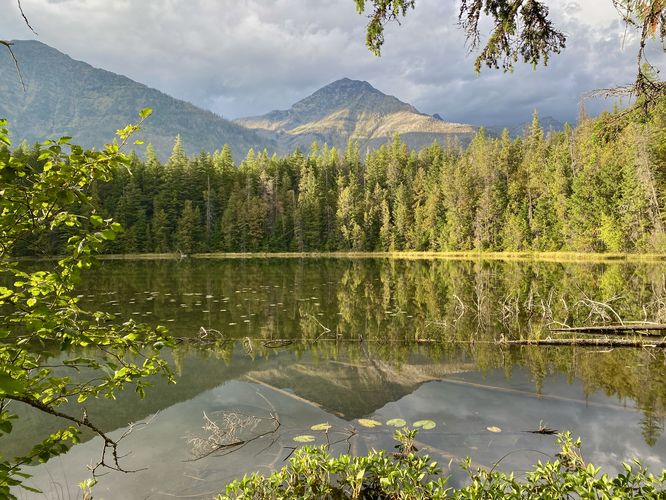
Johns Lake - Mile 0.55

Hikers will find an offshoot trail around mile 0.5 that leads to the shores of Johns Lake. Follow this short trail to reach the muddy banks of the water where you'll find reflection views of the nearby mountains. The trail near the water is often very muddy so watch your step while attempting to reach the best views of the water. From Johns Lake, you'll find Mount Stanton to the left (west) and Mount Vaught straight ahead (northwest).

After exploring Johns Lake, this route leads back to parking for a short 1.1-mile out-and-back hike; however, if the entire loop is clear of construction or not temporarily closed, you can continue onward to reach the Sacred Dancing Cascade & McDonald Falls via the Johns Lake Loop. If hiking out-and-back, the walk back to parking easy and mostly all downhill. Don't forget to enjoy the mushrooms, moss, and ferns of this dark evergreen-filled forest on the way out.

Johns Lake Loop

Hikers who visit the park may be familiar with the Johns Lake Loop which includes a hike to Sacred Dancing Cascade, McDonald Falls, and Johns Lake. This hike follows a portion of that route to reach Johns Lake; however, during our visit in September 2024, a portion of the road was closed which forced hikers to walk further along the Going-to-the-Sun Road to complete the popular loop. We decided instead that we would explore the lake and waterfalls separately. If you wish to explore further, check out our Sacred Dancing Cascade & McDonald Falls guide where you can plan your own route accordingly.

Parking

Hikers will find a very small parking turnout located near the coordinates provided along the Going-to-the-Sun Road. The turnout is large enough to fit a half-dozen vehicles as of September 2024.

Popularity

This is one of the more popular and crowded spots within Glacier National Park.

Vehicle Reservations

Depending on what time of year you visit, you may need to reserve a vehicle entrance pass to get into the park, in addition to a park entry fee (or annual National Parks pass). Before planning this hike, ensure you've checked the NPS website for when and where Glacier NP vehicle reservations are required.

Pets

Dogs are not allowed on any trails at Glacier National Park.

Warning

Grizzly bears: This trail can be frequented by grizzly bears, especially in late Summer and early Fall as they scrounge for 20 hours/day bulking for the winter. Always give wild animals plenty of space, including several hundred feet for grizzlies. It's best to bring bear spray on this hike as a last defense just in case a grizzly were to charge at you. Always make plenty of noise while hiking to alert animals to your presence long before you see them. It's also smart to hike with another person.
Explore 43 trails near West Glacier, MT
  1. Parking

    48.633463, -113.86229
  2. Main Trailhead

    48.633398, -113.862204
  3. View of Johns Lake and Mount Vaught

    48.637147, -113.855928
    View of Johns Lake and Mount Vaught
No community routes found. To add your own hike as a Community Route for this Trail guide, leave a Trip Report with an attached GPX file.

Seasons

Spring, Summer, Fall

Trip Reports

Trail Guide By:
Admin user profile picture
1.1 miles / 1.8 km
1.1 miles / 1.8 km
September 18, 2024
Lake was pretty. We found a large grizzly bear paw imprint on the trail on our hike out.
Hiking

Weather Forecast

In West Glacier, MT

Explore Hiking Trails

You May Also Like

Colorado's Million Dollar Highway - Plan a day's drive adventure along the iconic Million Dollar Highway in Colorado. Explore the best short trails, roadside stops, waterfalls, vistas, ghost towns, and hot springs within a ~6 hour road trip.
Explore

Colorado's Million Dollar Highway

Plan a day's drive adventure along the iconic Million Dollar Highway in Colorado. Explore the best short trails, roadside stops, waterfalls, vistas, ghost towns, and hot springs within a ~6 hour road trip.

Read
Glacier's Going-to-the-Sun Road - Discover the breathtaking beauty of Glacier National Park along the iconic Going-to-the-Sun Road. From stunning roadside stops to picturesque waterfalls and vistas, this engineering marvel offers endless opportunities for exploration.
Explore

Glacier's Going-to-the-Sun Road

Discover the breathtaking beauty of Glacier National Park along the iconic Going-to-the-Sun Road. From stunning roadside stops to picturesque waterfalls and vistas, this engineering marvel offers endless opportunities for exploration.

Read
New York's Best Waterfalls - Whether you're planning a day hike, roadside stop, or a leisurely short walk, this guide provides hikers, travelers, and locals alike with 63 different locations to over 100 scenic waterfalls to help plan your next adventure!
Explore

New York's Best Waterfalls

Whether you're planning a day hike, roadside stop, or a leisurely short walk, this guide provides hikers, travelers, and locals alike with 63 different locations to over 100 scenic waterfalls to help plan your next adventure!

Read

Before you boogie...

Find our trail guides useful? Consider becoming a Supporter to unlock perks!

MyHikes is an indie platform that makes exploring public trails easier for everyone. The platform has no investors, no ads, and is owned and operated by one person, Dave Miller. Dave has personally mapped and written over 1,800 trail guides on MyHikes for the public to explore. MyHikes has helped millions outdoor enthusiasts plan their next adventure.

But it takes a lot of time ๐Ÿ•ฆ, money ๐Ÿ’ฐ, work, and espresso shots โ˜• to run MyHikes, including hiking , mapping , writing , and publishing new trails with high-quality (accurate) information... along with software engineering (coding) the platform like building new features, website and mobile app development (iOS and Android), site maintainance . and much much more.

Supporters unlock website and mobile app perks with an annual one-time payment of $25 (you renew) ๐Ÿ˜Ž๐Ÿ‘. Or you can simply make a Donation of your choice. Otherwise, you can support us by telling your friends about MyHikes - both quick and free ๐ŸŽ‰

Admin user profile picture

Dave Miller
MyHikes Founder