The Jacoby Falls Trail at Loyalsock State Forest near Trout Run, Pennsylvania is a moderate 3.8-mile out-and-back trail that leads to the popular 25-foot tall waterfall named Jacboy Falls.
Hike Description
This hike starts at the trailhead located along Wallis Run Road in Trout Run, PA at the Cotner Farm recreational trailhead. The first section of the hike follows wooden planks that sit above the otherwise muddy ground. Shortly after passing the wooden plank section of the trail, hikers will pass Cheryls Trail on their left-hand side. Stay right at this junction to continue following the white blazes.
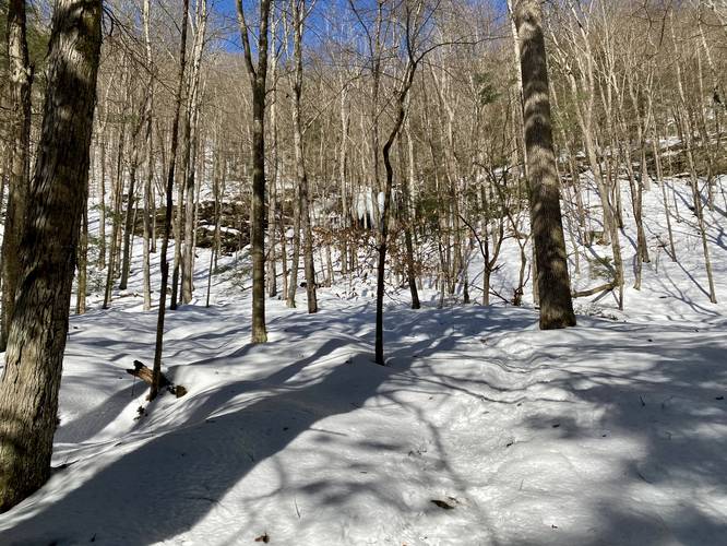
The trail is relatively flat for the first half of the hike as the trail meanders its way through the forest and next to a creek. Eventually the trail will head gradually uphill along the banks of the creek - this section of the hike is considered moderate, but is still relatively easy nonetheless.
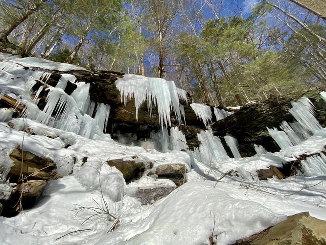
Eventually, around mile 1.3, hikers will notice a brown sign (similar to that of the Cheryls Trail sign) labled "Please Stay on Trail". At this sign, the trail begins to follow a gas pipeline; however, hikers will also find a 2nd 20-foot unnamed waterfall in the hill behind them at this junction. During the warm months, when the waterfall is flowing, hikers should be able to hear it flowing, but it appears to be seasonal so it could just be a trickle. At the brown sign, continue hiking alongside the creek for about 50 to 100-feet and then take a left-hand turn which heads up a tributary creek - this leads to the unnamed 20-foot tall waterfall, as an additional bonus on the way to Jacoby Falls.
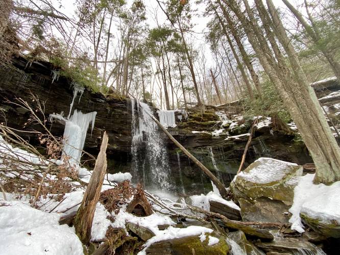
From here, hikers will continue back downhill from the unnamed waterfall, or skip it altogether, to the main trail. The trail follows the western side of the creek as it makes its way up to Jacoby Falls following the gas pipeline for most of the journey to the waterfall. Hikers will notice the pipeline heads back uphill, across the creek, approximately 0.1-miles from the waterfall. The trail meanders its way alongside the creek, passing several smaller cascades, before finally reaching Jacoby Falls around mile 1.8.
The hike back to parking is the same as the hike in, but easier since the hike out is mostly all downhill or mostly-flat.
Jacoby Falls
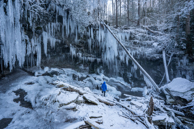
This waterfall appears to flow year-round and cascades about 25-feet as a free-falling waterfall. There are several smaller cascades that flow down the creek just below Jacoby Falls as well. During the winter, massive chunks of ice will build-up around the waterfall, which is really pretty, but can also be dangerous when the ice begins to melt and chunks fall off. Hike at your own risk.
Unnamed Waterfall
Around mile 1.4 hikers will reach the unnamed seasonal waterfall. The waterfall here cascades over a 5-foot deep rock ledge, which hikers can walk behind. During the winter, and especially in the late winter when the ice is melting, the waterfall can be dangerous to approach as large chunks of ice can fall from the cliffs and the waterfall itself. Hike at your own risk
Blaze Color
This trail follows white blazes. As of February 2021, the old blazes (yellow) were painted over with white, but some blazes were missed and are still yellow. Other blazes are clearly fading back to yellow. Note that most of the pipeline is blazed with yellow and scarce white blazes.
Parking
Hikers will find a large parking lot at the coordinates provided. The parking lot is large enough to fit a dozen vehicles or more. Because of this trail's popularity, the state keeps the parking lot clear during the winter as well.
Pets
Dogs are allowed if leashed and their waste should be carried out by the hiker.
Popularity
This trail is a very popular waterfall hike near Williamsport, PA, so plan for plenty of hikers at this trail during weekends.
Warning
Rattlesnakes: While rare, the Timber Rattlesnake lives in this area and tends to come down to creeks to cool down or hunt between the end of April through the end of September. Watch your step and give any rattlesnake you see some space.
Hike Description
This hike starts at the trailhead located along Wallis Run Road in Trout Run, PA at the Cotner Farm recreational trailhead. The first section of the hike follows wooden planks that sit above the otherwise muddy ground. Shortly after passing the wooden plank section of the trail, hikers will pass Cheryls Trail on their left-hand side. Stay right at this junction to continue following the white blazes.
The trail is relatively flat for the first half of the hike as the trail meanders its way through the forest and next to a creek. Eventually the trail will head gradually uphill along the banks of the creek - this section of the hike is considered moderate, but is still relatively easy nonetheless.
Eventually, around mile 1.3, hikers will notice a brown sign (similar to that of the Cheryls Trail sign) labled "Please Stay on Trail". At this sign, the trail begins to follow a gas pipeline; however, hikers will also find a 2nd 20-foot unnamed waterfall in the hill behind them at this junction. During the warm months, when the waterfall is flowing, hikers should be able to hear it flowing, but it appears to be seasonal so it could just be a trickle. At the brown sign, continue hiking alongside the creek for about 50 to 100-feet and then take a left-hand turn which heads up a tributary creek - this leads to the unnamed 20-foot tall waterfall, as an additional bonus on the way to Jacoby Falls.
From here, hikers will continue back downhill from the unnamed waterfall, or skip it altogether, to the main trail. The trail follows the western side of the creek as it makes its way up to Jacoby Falls following the gas pipeline for most of the journey to the waterfall. Hikers will notice the pipeline heads back uphill, across the creek, approximately 0.1-miles from the waterfall. The trail meanders its way alongside the creek, passing several smaller cascades, before finally reaching Jacoby Falls around mile 1.8.
The hike back to parking is the same as the hike in, but easier since the hike out is mostly all downhill or mostly-flat.
Jacoby Falls
This waterfall appears to flow year-round and cascades about 25-feet as a free-falling waterfall. There are several smaller cascades that flow down the creek just below Jacoby Falls as well. During the winter, massive chunks of ice will build-up around the waterfall, which is really pretty, but can also be dangerous when the ice begins to melt and chunks fall off. Hike at your own risk.
Unnamed Waterfall
Around mile 1.4 hikers will reach the unnamed seasonal waterfall. The waterfall here cascades over a 5-foot deep rock ledge, which hikers can walk behind. During the winter, and especially in the late winter when the ice is melting, the waterfall can be dangerous to approach as large chunks of ice can fall from the cliffs and the waterfall itself. Hike at your own risk
Blaze Color
This trail follows white blazes. As of February 2021, the old blazes (yellow) were painted over with white, but some blazes were missed and are still yellow. Other blazes are clearly fading back to yellow. Note that most of the pipeline is blazed with yellow and scarce white blazes.
Parking
Hikers will find a large parking lot at the coordinates provided. The parking lot is large enough to fit a dozen vehicles or more. Because of this trail's popularity, the state keeps the parking lot clear during the winter as well.
Pets
Dogs are allowed if leashed and their waste should be carried out by the hiker.
Popularity
This trail is a very popular waterfall hike near Williamsport, PA, so plan for plenty of hikers at this trail during weekends.
Warning
Rattlesnakes: While rare, the Timber Rattlesnake lives in this area and tends to come down to creeks to cool down or hunt between the end of April through the end of September. Watch your step and give any rattlesnake you see some space.