Loading...

🎉 Find content tailored to you in the For You tab! Learn More.

Ice Box Canyon Trail

The Ice Box Canyon Trail at Red Rock Canyon National Conservation Area near Las Vegas, Nevada is a strenuous 2.3-mile out-and-back hike that leads to a seasonal desert canyon waterfall.

Trail names: Ice Box Canyon Trail

Location: Red Rocks National Park, 1000 Scenic Loop Drive, Las Vegas Nevada

Permitted uses: Hiking

Prohibited uses: Speed limit on the Scenic Loop drive is 35 mph. Parking is allowed in designated parking areas only. Do not disturb wildlife. Do not feed wild horses or burros.

Hours: Dawn to Dusk. Exit times are posted at each trailhead for each season.

Fees and Parking: There is a daily fee charged for each car, motorcycle, bicycle or pedestrian. Reservations for timed entry are required between 8:00am and 5:00pm. Reservations can be made by visiting recreation.gov. A $2.00 fee was charged to process a reservation. This fee will be in addition to the park entry fee. A one-day pass for Cars/trucks is $20.00/per vehicle with up to 4 adults including the driver. Motorcycles $10.00 per vehicle, Bicyclist $8.00 per bicycle, Pedestrian $5.00/per person. Annual passes are available, and Lifetime “America the Beautiful” passes are honored. Payment is accepted in either cash or credit card. Children under 15 years of age are admitted free of charge. There is ample parking at each trailhead.

Pets: Dogs on a leash are allowed. Please leave no trace, which means do not leave bagged dog waste or trash along the trail.

Accessibility: This trail is not wheelchair accessible and is not advised for those with any mobility issues. The trail has a lot of uneven terrain and lots of rock scramble.

Hiker amenities: Restrooms and trash bins are located near the parking area.

Length and Trail information: Ice Box Canyon Trail is one of the 26 numbered trails inside the Red Rock Canyon National Park off of the 13-mile scenic loop drive. Hikers can download a map of the trail system by visiting redrockcanyonlv.org. Ice Box Canyon Trail is #16 on the downloadable map. This hike was done as an “out and back” hike.

The trail is marked by narrow brown conservation posts and are more frequently placed on the part of the trail that crosses the desert to the Canyon. Once inside the rocky canyon area, the markers seem to be less. It should be noted that hikers need to pay very close attention to their GPS, as it is very easy to get off trail, especially when descending in the wash area.

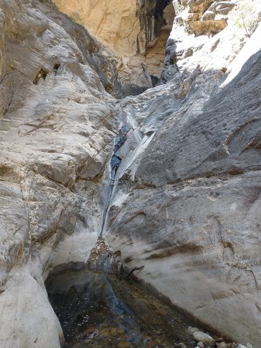
Ice Box Canyon Trail is rated as Difficult and is 2.3 miles long with a change in elevation of about 400 ft. The difficult part of the hike are the rock scrambles that need to be navigated. If hikers visit in the spring, they are likely to see a beautiful waterfall as a result of either rain or melting snowpack at the end of the Canyon. We were lucky enough to see pools of water in the Canyon as well as a small, but steady flowing waterfall at the end of our hike. The Canyon walls on either side are awe-inspiring.

Although this is the desert, during the spring there are lots of plants in full bloom. We were able to see Dorr’s sage, Plains Pricklypear, Western Redbud, Beavertail Pricklypear, Desert Marigold and Apricot Mallow all in bloom. The Singleleaf Pinyons were absolutely loaded with pollen, and the Junipers were full to the brim with berries. If you enjoy birding, then this hike is a must do. During our hike we were able to identify hearing the following birds: House Finch, White-throated Swifts, Violet-green Swallows, Cassin’s Vireo, Pygmy Nuthatch, California Scrub-jay, and Plumbeous Vireo. No doubt this area is attractive to birds and wildlife thanks to the water source.

Ice Box Canyon Trail is a great hike, and despite it being rated as “Difficult” I would gladly return and hike this trail again. The rock scrambles are fun and the payoff of the waterfall at the end can’t be beat.

Explore 13 trails near Las Vegas, NV

Know Before You Go

  • Ice Box Canyon Trail in Red Rock Canyon near Las Vegas is a strenuous 2.3-mile hike with a seasonal waterfall, requiring careful navigation due to potential off-trail wandering and rock scrambles.
  • Hiking the trail requires a timed entry reservation and a park entry fee, allows dogs on leashes, and offers amenities like restrooms and trash bins at the parking area.
  • The trail showcases diverse flora and fauna, including blooming desert plants and various bird species, especially during spring.
Interactive topographic map for Ice Box Canyon Trail located in Las Vegas, NV. Click the "View Map" button to load GPS coordinates and trail markers.
Get directions
Distance
2.3 mi
Difficulty
Strenuous
Type
Out-and-Back
Est. Time
1.2 hrs
Elev. Gain
600'
Rating
0.0
Added
May 25, 2024
Updated
July 20, 2024

Weather Forecast

Today
High 64°F
Mostly Cloudy
Tonight
Low 48°F
Mostly Cloudy then Chance Rain Showers
Wednesday
High 61°F
Chance Rain Showers
Wednesday Night
Low 39°F
Chance Rain Showers
Thursday
High 60°F
Slight Chance Rain Showers
Thursday Night
Low 40°F
Slight Chance Rain Showers
Friday
High 62°F
Sunny
Friday Night
Low 40°F
Mostly Clear
Saturday
High 63°F
Mostly Sunny
Saturday Night
Low 40°F
Mostly Cloudy
Sunday
High 60°F
Mostly Cloudy then Slight Chance Rain Showers
Sunday Night
Low 37°F
Chance Rain Showers then Chance Rain And Snow Showers
Washington's Birthday
High 53°F
Rain And Snow Showers Likely
Monday Night
Low 35°F
Rain And Snow Showers Likely
Loading...
Total Change
449'
Ascent
600'
Descent
654'
Loading...

Download the GPX Data for Offline Use

Supporters get exclusive access to download trail routes to the MyHikes app for offline use. Stay prepared on your adventure, even without an internet connection! Become a Supporter today to unlock this feature and hike with confidence.

Download Ice Box Canyon Trail GPX Data to the MyHikes Mobile App

Features

Dogs
Waterfalls
Water Source

Points of interest

  1. Parking

    36.150092, -115.484087
  2. Main Trailhead

    36.150014, -115.484017

Safety information

For your own safety: plan ahead, let someone know where you'll be, and hike at your own risk.

Hazards

Snakes (Rattlesnakes, Copperheads, others)
Rockfalls, Ledges, or Scrambles

Availability

All seasons

Surface type

Dirt

Trip Reports (Reviews)

Your opinion matters! Be the first to rate this trail.

Ready to help fellow hikers? Add a trip report to share your experience and provide valuable insights for other hikers!

No community routes found. To add your own hike as a Community Route for this Trail guide, leave a Trip Report with an attached GPX file.

Popular categories

Scenic mountain view representing vista trails
Vista trails
Scenic gorge of cascades representing waterfall trails
Waterfall hikes
Rugged mountain terrain representing summit trails
Summit trails
Scenic mountain view representing dog-friendly trails
Dog-friendly
Scenic campsite with a view representing camping trails
Camping trails
Appalachian Trail logo representing A.T. hikes
A.T. hikes

You May Also Like

Colorado's Million Dollar Highway - Plan a day's drive adventure along the iconic Million Dollar Highway in Colorado. Explore the best short trails, roadside stops, waterfalls, vistas, ghost towns, and hot springs within a ~6 hour road trip.
Explore

Colorado's Million Dollar Highway

Plan a day's drive adventure along the iconic Million Dollar Highway in Colorado. Explore the best short trails, roadside stops, waterfalls, vistas, ghost towns, and hot springs within a ~6 hour road trip.

Read
Glacier's Going-to-the-Sun Road - Discover the breathtaking beauty of Glacier National Park along the iconic Going-to-the-Sun Road. From stunning roadside stops to picturesque waterfalls and vistas, this engineering marvel offers endless opportunities for exploration.
Explore

Glacier's Going-to-the-Sun Road

Discover the breathtaking beauty of Glacier National Park along the iconic Going-to-the-Sun Road. From stunning roadside stops to picturesque waterfalls and vistas, this engineering marvel offers endless opportunities for exploration.

Read
🍪 We use cookies to learn about site usage and to serve map tiles. You may block cookies manually in the browser. By continuing you agree. Learn more