The Huntley Mountain Fire Tower Site hike at Tiadaghton State Forest in Waterville, Pennsylvania is an easy 0.6-mile out-and-back hike that leads up to the long-abandoned fire tower location.
Hike Description
This hike begins at the very end of Huntley Road atop Huntley Mountain in Waterville - note there's a small parking turnout just before the large yellow gate that leads down the road to the fracking sites. Here is also where the old service road for the Huntley Mountain Fire Tower / Lookout Tower can be found. Follow the old service road through the woods - it's an obvious wide path that's cut out between the trees next to the parking area.
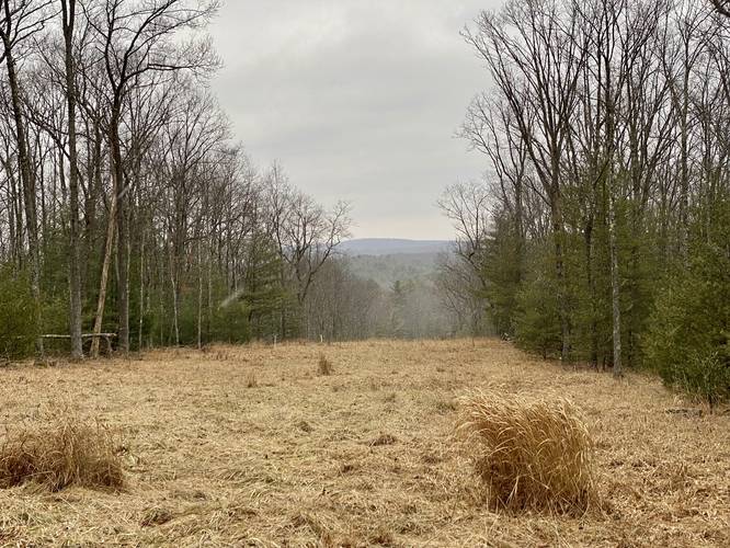
Pipeline Vista - Mile 0.1
At mile 0.1, just after the trail begins its ascent, hikers will enter a large open space - a pipeline. To the right-hand side of the trail (western side) is a nice view of the tops of the neighboring mountains on the west side of Pine Creek. Note that while this isn't the nicest vista, it's the only view along the hike.
Hemlock Grove - Mile 0.2
Around mile 0.2, hikers will enter a beautiful hemlock grove, which gives the trail a different feel to it. Here is also where the trail begins to level out along a flatter grade as it approaches the long-abandoned fire tower site.
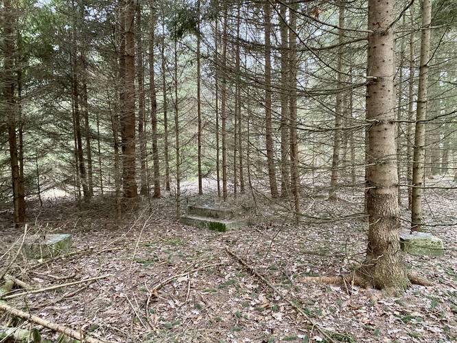
Fire Tower Site - Mile 0.3
At mile 0.3, hikers will find the old Huntley Mountain Fire Tower site located on the eastern (left-hand) side of the trail. It's easy to miss; however, the best way to locate it is by noticing the lower-growing Spruce grove. Look to the east of these Spruce trees and you'll locate several concrete pilings / footings and two concrete steps located just off-trail under a large hemlock tree. These old concrete pillars were once used to secure the old fire tower to the mountain as there's no natural bedrock located here.
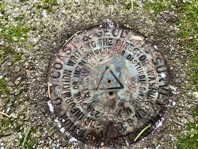
USGS Benchmark
Located at the old fire tower site is an old USGS benchmark (summit marker) which are likely no longer useful to surveyors; however, this marker was placed here for the fire tower as many other fire tower sites in the area have old markers left over from that era. Please leave the marker alone for other explorers to find later in life!
Parking
Hikers will find a small parking turnout just before the large yellow gate that leads down the road to the fracking sites, located at the coordinates provided - at the end of Huntley Road.
Pets
Dogs are allowed if leashed and their waste should be carried out by the hiker.
Hike Description
This hike begins at the very end of Huntley Road atop Huntley Mountain in Waterville - note there's a small parking turnout just before the large yellow gate that leads down the road to the fracking sites. Here is also where the old service road for the Huntley Mountain Fire Tower / Lookout Tower can be found. Follow the old service road through the woods - it's an obvious wide path that's cut out between the trees next to the parking area.
Pipeline Vista - Mile 0.1
At mile 0.1, just after the trail begins its ascent, hikers will enter a large open space - a pipeline. To the right-hand side of the trail (western side) is a nice view of the tops of the neighboring mountains on the west side of Pine Creek. Note that while this isn't the nicest vista, it's the only view along the hike.
Hemlock Grove - Mile 0.2
Around mile 0.2, hikers will enter a beautiful hemlock grove, which gives the trail a different feel to it. Here is also where the trail begins to level out along a flatter grade as it approaches the long-abandoned fire tower site.
Fire Tower Site - Mile 0.3
At mile 0.3, hikers will find the old Huntley Mountain Fire Tower site located on the eastern (left-hand) side of the trail. It's easy to miss; however, the best way to locate it is by noticing the lower-growing Spruce grove. Look to the east of these Spruce trees and you'll locate several concrete pilings / footings and two concrete steps located just off-trail under a large hemlock tree. These old concrete pillars were once used to secure the old fire tower to the mountain as there's no natural bedrock located here.
USGS Benchmark
Located at the old fire tower site is an old USGS benchmark (summit marker) which are likely no longer useful to surveyors; however, this marker was placed here for the fire tower as many other fire tower sites in the area have old markers left over from that era. Please leave the marker alone for other explorers to find later in life!
Parking
Hikers will find a small parking turnout just before the large yellow gate that leads down the road to the fracking sites, located at the coordinates provided - at the end of Huntley Road.
Pets
Dogs are allowed if leashed and their waste should be carried out by the hiker.