Looking for a fun, but difficult historical hike in the PA Grand Canyon with a bit of off-trail exploration? Look no further than the Horn's Quarry Vista Hike in Jersey Mills, Pennsylvania! Situated near the southern end of the PA Grand Canyon in Tiadaghton State Forest, this hike leads you along the seasonal creek, Callahan Run, up to several old flagstone quarry cuts in the mountainsides that were once owned and operated by the Horn family.
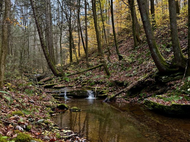
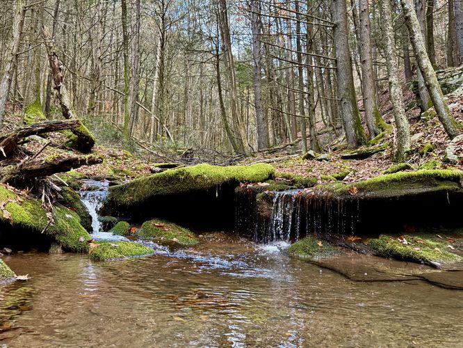
The Callahan Run Trail leads you north as it traverses alongside the seasonal creek waters of Callahan Run. Along the way, you'll find small waterfalls (more or less tiny cascades) that spill down the creek's bedrock, forming scenic but short water features. You'll also find steep mountainsides, mosses, and ferns that fill the forest floor.
Near mile 3.6, the off-trail adventure starts where you'll cross Callahan Run once more before scrambling up the hillside. Follow the mountain hollow for 0.15 miles, then bushwhack your way uphill further through rhododendrons. Eventually, you'll spot a large rock outcropping on the mountainside, this is the main area of Horn's Quarry! The old quarry circles around the mountainside as it sits between two seasonal creeks. Watch your step, however, as there are plenty of old depressions in the ground, likely left over from quarry work.
On the southern side of Horn's Quarry sits another rock cut just below the seasonal creek where you'll find a 15-foot tall waterfall. This waterfall is only worth visiting if you show up during the Spring or after periods of heavy rainfall. Following the old quarry trail, likely used by wagons, you'll make your way out of Horn's Quarry as it leads back downhill to reach Callahan Run. Be warned though, the trail is not maintained and is full of small saplings. Near mile 4.35, you'll cross Callahan Run once more to reach the hike back to parking.
Falling rock: This hike leads visitors to old quarries where rockfall could occur at any time. It's best to stay away from these loose rock ledges at all times for your own safety.
Off-trail hiking: This route leads hikers through areas of off-trail exploration, bushwhacking, and areas with no or little blaze markers. Off-trail navigation skills are required and it's best to download a mobile app to track your location to ensure you do not get lost, like the MyHikes app!
Trails
This hike follows several named trails, but it also leads through the forest along bushwhacks. The named trails are as follows: Callahan Run Trail and Pikes Peak Trail. Note: The route leads through bushwhack, off-trail areas and along some long-lost quarry roads that were once built to send carriages and small train cars to round-up and collect the quarried flagstone to ship out for retail. This hike is not for the faint of heart and a good offline navigation app, like the MyHikes app, are recommended to ensure your safety.Hiking to Horn's Quarry Vista - Mile 0 to 2.6
This hike begins along Callahan Run Road where hikers will find no real trailhead or parking turnout, however, once you're on the Callahan Run Trail, there's plenty of spaces along the road where you can fit one or two vehicles. Hiking down the Callahan Run Trail, you'll eventually reach a yellow forest gate, which is another place you can park your vehicle to reduce a small amount of mileage.The Callahan Run Trail leads you north as it traverses alongside the seasonal creek waters of Callahan Run. Along the way, you'll find small waterfalls (more or less tiny cascades) that spill down the creek's bedrock, forming scenic but short water features. You'll also find steep mountainsides, mosses, and ferns that fill the forest floor.
Hike up Mullen Run - Mile 1.77 to 2
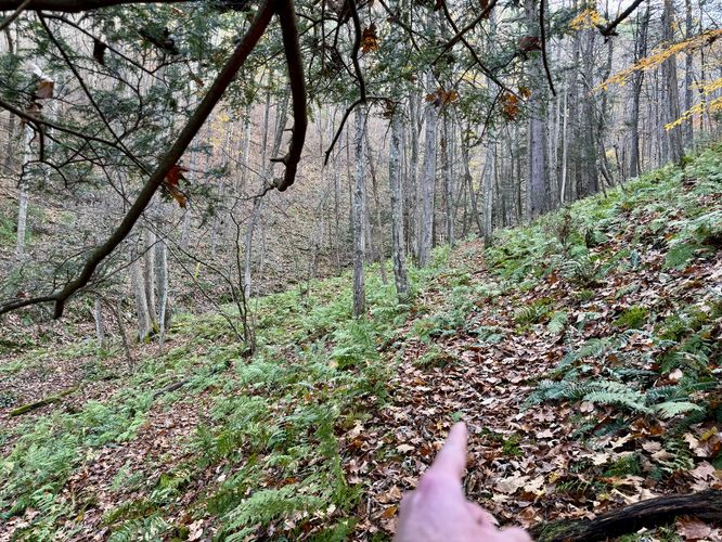
The hike up the Callahan Run Trail is straight forward, but to reach the vista, you'll need to be on the lookout for Mullen Run near Mile 1.77. Mullen Run, another seasonal creek, spills down through a mountain hollow where the officially-named Pikes Peak Trail starts; however, as of November 2025, there are no blazes that mark the trail. Here, you can hike down the steep hillside from the Callahan Run Trail, cross Callahan Run, and then hike up the side of Mullen Run as it leads up a steep, rocky mountain hollow. The traverse up Mullen Run is not easy, eventually the Pikes Peak Trail leads directly into Mullen Run before you'll think to yourself "why am I here?". Once you realize that the Pikes Peak Trail has essentially disappeared, now it's time to scale the mountainside up along loose, slippery, and dangerous rock slabs. Be extra careful that you do not ride these loose rocks down the mountain... After bushwhacking up from Mullen Run, near the 2-mile marker, you'll reach an actual trail that runs along the side of the mountain, which is the continuation of the Pikes Peak Trail. Here, you'll also locate the northern-most flagstone cuts of Horn's Quarry!Horn's Quarry (North) - Mile 2 to 2.1
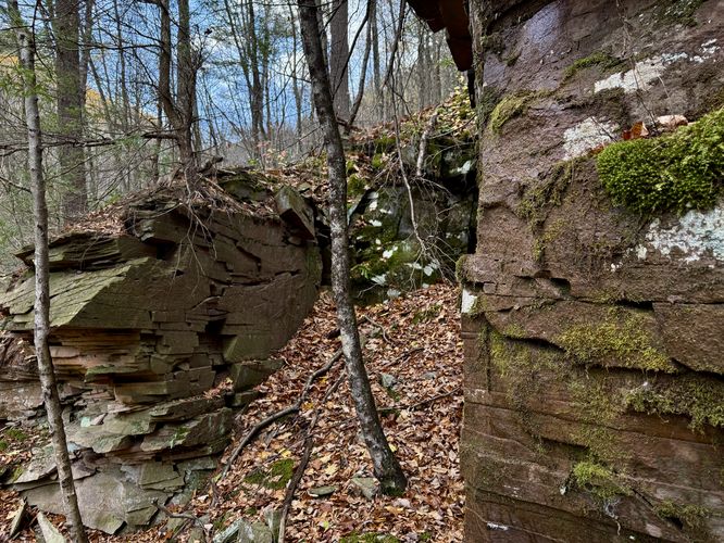
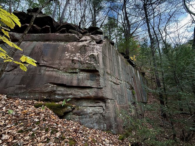
Once you reach the old quarry trail (Pikes Peak Trail), hikers will find large cliffs that were once part of the long-gone quarry (Horn's Quarry). Here, you'll find built-up rock walls, some small cave-like features, and large sections of mountainside that were cut out for retail. It's fun poking around these old quarry walls, some of which stand over 30-feet tall. Watch out for loose, falling rock!Reaching Horn's Quarry Vista - Mile 2.1 to 2.6
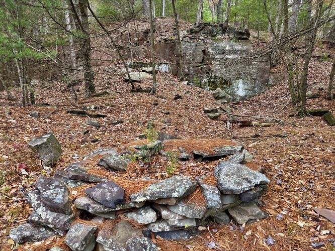
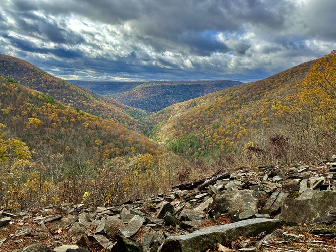
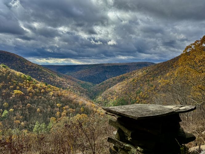
The next stop along the hike is the vista you came out here for, Horn's Quarry Vista! After leaving the northern quarry cuts, the Pikes Peak Trail runs uphill along the mountainside, passing more quarry cliffs, until it eventually reaches the viewpoint near mile 2.6. At the viewpoint, hikers will find a stunning 180-degree view toward the heart of the PA Grand Canyon from the mountainside. Here, you can sit, relax, and eat a snack while you take in the views of the rolling mountains that sit alongside the PA Grand Canyon. A perfect place for solitude! Near the Horn's Quarry Vista are, as you may have guessed, even more quarry cuts. There's even a campsite area. But beware of the rocky outcroppings, piles of rock, and potential for rattlesnake dens and habitats as this remote area is perfect for rattlers to live.Hiking Down to Callahan Run - Mile 2.6 to 3.1
After you spend time exploring the beautiful view from Horn's Quarry Vista, the hike leads you down the mountain by following yet another long-lost trail. This path, technically not on the state forest maps, runs from the vista southward before it curves back down the mountain to reach Callahan Run. The trail can be steep and covered in leaves for most sections, so watch your step. Once on Callahan Run, the hike back to parking is straight forward if you wish to skip the large, main area of Horn's Quarry!Optional Hike to Horn's Quarry - Mile 3.6 to 4.35
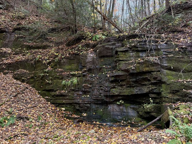
After exploring the Horn's Quarry Vista, which is really the only reason to hike out along Callahan Run (beside hunting), there's one last optional stop along the way out, the main area for Horn's Quarry. I originally learned about Horn's Quarry in the book Pine Creek Villages by David Ira Kagan where he included a photo from 1900 of wagons, flagstone, and the workers at Horn's Quarry, so I wanted to find the exact location... and this route leads directly to that main quarry site!Near mile 3.6, the off-trail adventure starts where you'll cross Callahan Run once more before scrambling up the hillside. Follow the mountain hollow for 0.15 miles, then bushwhack your way uphill further through rhododendrons. Eventually, you'll spot a large rock outcropping on the mountainside, this is the main area of Horn's Quarry! The old quarry circles around the mountainside as it sits between two seasonal creeks. Watch your step, however, as there are plenty of old depressions in the ground, likely left over from quarry work.
On the southern side of Horn's Quarry sits another rock cut just below the seasonal creek where you'll find a 15-foot tall waterfall. This waterfall is only worth visiting if you show up during the Spring or after periods of heavy rainfall. Following the old quarry trail, likely used by wagons, you'll make your way out of Horn's Quarry as it leads back downhill to reach Callahan Run. Be warned though, the trail is not maintained and is full of small saplings. Near mile 4.35, you'll cross Callahan Run once more to reach the hike back to parking.
Hiking Out - Mile 4.35 to 4.8
The last section of the hike leads you down the Callahan Run Trail to reach parking to wrap up this 4.8 mile out-and-back hike to Horn's Quarry Vista and the long-gone rock cuts of Horn's Quarry!Parking & Directions: How to Get to Horn's Quarry Vista
To get to Horn's Quarry Vista, hikers will want to drive through the PA Grand Canyon along PA-414 to reach Callahan Run Road in Jersey Mills. Follow the road as it leads northeast before it curves around a bend, crossing the creek of Callahan Run. Take the immediate right-hand turn to drive down the Callahan Run Trail. Once on the Callahan Run Trail, you'll find parking near the coordinates provided: 41.361853, -77.410986. The hike starts here.Pets
Dogs are allowed if leashed and must be cleaned up after. Beware that this is rattlesnake territory!Warning
Timber Rattlesnakes: This area is home to the Timber Rattlesnake which can often be found roaming the forest floor between April and October. Rattlers love open, sunny, rocky places and Horn's Quarry Vista is one of those places. The terrain makes for perfect rattlesnake habitats, so always be on the lookout and keep and listen for rattlers!Falling rock: This hike leads visitors to old quarries where rockfall could occur at any time. It's best to stay away from these loose rock ledges at all times for your own safety.
Off-trail hiking: This route leads hikers through areas of off-trail exploration, bushwhacking, and areas with no or little blaze markers. Off-trail navigation skills are required and it's best to download a mobile app to track your location to ensure you do not get lost, like the MyHikes app!