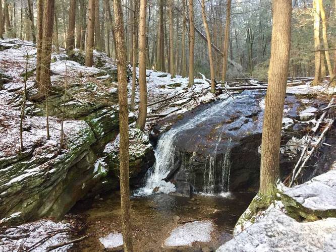
The Holland Glen Trail is an easy 0.8 mile loop hike up to the small waterfall - Hop Brook Falls, in Belchertown, Massachusetts. Hop Brook Falls is the main attraction on this trail and is well worth the trip in the early Spring, the dead of winter, or after a recent rainfall. The waterfall's cascade starts off on a gradual slope heading down the creek on a large rock formation before falling about 6 or 7 feet into the pool below. The surrounding forest is mainly coniferous, so the entire area just feels like a hidden gem in the middle of western Massachusetts.
Trail Description
The hike begins at a small parking turnout located near the parking coordinates provided. The trail heads gradually uphill following a rocky path along Hop Brook into Holland Glen.
Hikers will reach a split in the trail after the trail takes a left-hand turn around a bend in Hop Brook. The trail on the right crosses a small footbridge across Hop Brook and heads uphill for a steeper and more difficult hike; however, this recording heads up the left-hand side of Hop Brook and down the right-hand side (track recorded in 2015).
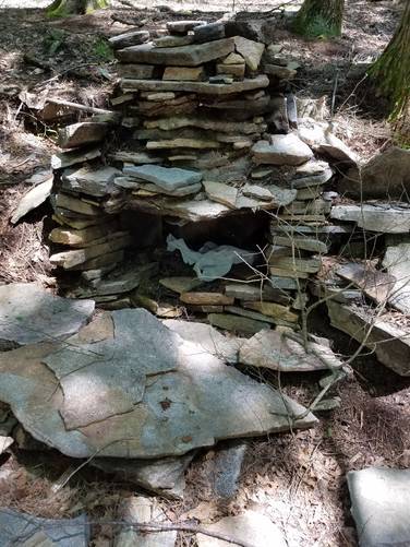
Once you reach Hop Brook Falls, there's an overlook ledge next to a campfire ring that gives you a view above the falls from above -- if you hiked up the right-hand side of the loop. If you hiked up the western side of the loop, you'll have to cross the creek to reach this overlook and campsite; however, there have been designated campsites on either side of Hop Brook for quite some time.
To complete the loop, cross Hop Brook above the waterfall, to hike back down to parking.
Parking
There's a small parking turnout in the woods near the coordinates provided. The lot is large enough for about 3 or 4 vehicles, but the parking space can get tight. Additional parking can be found along MA Route 9, but do not block the road or impede traffic and park at your own risk.
Camping
There's a campsite and campfire ring near the falls and plenty of people have camped there previously. There's no signage saying "no camping" nor have I (Admin) or anyone I've heard of anyone having trouble camping here. Be respectful, pack-in and pack-out and leave no trace.
Trail Description
The hike begins at a small parking turnout located near the parking coordinates provided. The trail heads gradually uphill following a rocky path along Hop Brook into Holland Glen.
Hikers will reach a split in the trail after the trail takes a left-hand turn around a bend in Hop Brook. The trail on the right crosses a small footbridge across Hop Brook and heads uphill for a steeper and more difficult hike; however, this recording heads up the left-hand side of Hop Brook and down the right-hand side (track recorded in 2015).
Once you reach Hop Brook Falls, there's an overlook ledge next to a campfire ring that gives you a view above the falls from above -- if you hiked up the right-hand side of the loop. If you hiked up the western side of the loop, you'll have to cross the creek to reach this overlook and campsite; however, there have been designated campsites on either side of Hop Brook for quite some time.
To complete the loop, cross Hop Brook above the waterfall, to hike back down to parking.
Parking
There's a small parking turnout in the woods near the coordinates provided. The lot is large enough for about 3 or 4 vehicles, but the parking space can get tight. Additional parking can be found along MA Route 9, but do not block the road or impede traffic and park at your own risk.
Camping
There's a campsite and campfire ring near the falls and plenty of people have camped there previously. There's no signage saying "no camping" nor have I (Admin) or anyone I've heard of anyone having trouble camping here. Be respectful, pack-in and pack-out and leave no trace.