Loading...

WINTER SALE! 50% OFF Supporter Accounts — now through January 31st. Learn More.

Hill Reservoir Hike

The Hill Reservoir hike in Pelham, Massachusetts is an easy 2.3-mile out-and-back scenic hike that leads to Hill Reservoir, features a 15-foot tall spillway waterfall, and turns-around at Amethyst Brook.

Hiking to Hill Reservoir

This hike begins along the skinny dirt road of Meetinghouse Road in Pelham. Hikers will find parking near the edge of the Buffam Falls Conservation Area where you'll find a couple of small turnouts.

To reach the trailhead, hike north on Meetinghouse Road from the parking turnout and be on the lookout for a wide trail that leads due-east. Once you're on the trail, it leads through a white pine and hemlock forest as it makes its way toward the reservoir.

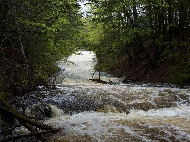
Hill Reservoir Falls - Mile 0.5

Around mile 0.5 from the parking area, hikers will reach a right-hand turn that leads downhill to reach the banks of Amethyst Brook. Head down to the water's edge to find a ~15-foot tall, 50-foot long waterfall that tumbles down from Hill Reservoir — Hill Reservoir Falls. While this human-made waterfall, specifically a spillway, isn't naturally occurring, the scenic tumbling water is a nice addition to the walk.

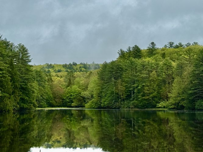
Hill Reservoir Views - Mile 0.6

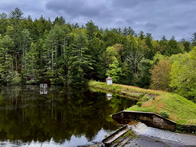
Just uphill from the waterfall sits the tranquil Hill Reservoir where hikers will find beautiful views of the water from the trail. Lining its banks are tall white pine trees and small hills. Before hiking onward, note that Hill Reservoir is the last truly scenic spot along this route. There are some small cascades in Amethyst Brook located at the turn-around point for this hike; however, if you don't wish to continue further, turning around at Hill Reservoir is not a bad option. If you wish to follow this guide, you can hike further to Amethyst Brook where you'll find a creek crossing.

Hiking to Amethyst Brook's Crossing - Mile 0.6 to 1.1

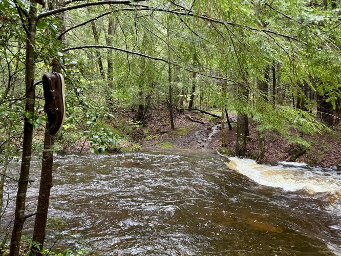
From Hill Reservoir, the trail leads up a small but steep hill. You can get more views of the reservoir from the top of this hill where you'll find a different perspective of the water. The trail, however, doesn't have much to offer once you leave the reservoir. It leads through the forest and eventually leads downhill to reach Amethyst Brook once more. At mile 1.1, you'll find a creek crossing at the brook. During our hike here in mid-May, the water level was way too high for us to consider crossing, so we hiked upstream a bit to explore the scenic, but small, cascades of water in the brook. Then we hiked out and back to parking for a 2.3-mile out-and-back hike.

Hiking Out - Mile 1.1 to 2.3

While you can certainly skip heading upstream along Amethyst Brook, the water and surrounding hemlocks are a scenic way to enjoy this part of Western Mass. The hike back to parking is simple — just follow the same path you hiked in on. Note that there's a bit of an uphill walk from Amethyst Brook to reach Hill Reservoir, but it's short lived and not difficult. Complete the 2.3-mile hike at the parking turnout along Meetinghouse Road.

Parking

Hikers will find small parking turnouts along Meetinghouse Road in Pelham. The turnouts are large enough to fit a couple of vehicles each. Note that Meetinghouse Road is a skinny dirt road where, in some places, opposing vehicles have to wait for one another. This road might not be maintained during the winter.

Pets

Dogs are not allowed in the reservoir or any of its tributaries. If you simply plan to keep your dog on-trail at all times, then dogs are allowed. It's illegal to allow your dog in the reservoir or upstream in Amethyst Brook according to the signage as of May 2025.

Prohibited

State law prohibits recreational use of the reservoir. No swimming, fishing, boating, skating, etc. Domestic animals are not allowed in the reservoir or its tributaries.
Explore 208 trails near Pelham, MA

Know Before You Go

  • The Hill Reservoir hike in Pelham, MA, is a 2.3-mile out-and-back trail featuring a 15-foot spillway waterfall (Hill Reservoir Falls) and views of Hill Reservoir.
  • The most scenic portions of the hike are the waterfall and the reservoir views, with the section beyond the reservoir to Amethyst Brook offering less visually appealing scenery.
  • Dogs are allowed on the trail but prohibited from entering the reservoir or its tributaries, and recreational use of the reservoir itself is forbidden.
Interactive topographic map for Hill Reservoir Hike located in Pelham, MA. Click the "View Map" button to load GPS coordinates and trail markers.
Get directions
Distance
2.3 mi
Difficulty
Easy
Type
Out-and-Back
Est. Time
1.2 hrs
Elev. Gain
287'
Rating
0.0
Added
May 10, 2025
Updated
June 11, 2025

Weather Forecast

Loading...
Total Change
251'
Ascent
287'
Descent
288'
Loading...

Download the GPX Data for Offline Use

Supporters get exclusive access to download trail routes to the MyHikes app for offline use. Stay prepared on your adventure, even without an internet connection! Become a Supporter today to unlock this feature and hike with confidence.

Download Hill Reservoir Hike GPX Data to the MyHikes Mobile App

Features

Vista / Lookout Point
Dogs
Waterfalls

Points of interest

  1. Parking

    42.379842, -72.449841
  2. Main Trailhead

    42.379842, -72.449841
  3. Hill Reservoir Falls (15-feet tall, 50-feet long)

    42.381206, -72.442911
    Hill Reservoir Falls (15-feet tall, 50-feet long)
  4. View of Hill Reservoir

    42.381922, -72.442114
    View of Hill Reservoir

Safety information

For your own safety: plan ahead, let someone know where you'll be, and hike at your own risk.

Hazards

Poison Ivy or Poison Oak

Availability

All seasons

Surface type

Dirt

Trip Reports (Reviews)

Your opinion matters! Be the first to rate this trail.

Ready to help fellow hikers? Add a trip report to share your experience and provide valuable insights for other hikers!

No community routes found. To add your own hike as a Community Route for this Trail guide, leave a Trip Report with an attached GPX file.

Popular categories

Scenic mountain view representing vista trails
Vista trails
Scenic gorge of cascades representing waterfall trails
Waterfall hikes
Rugged mountain terrain representing summit trails
Summit trails
Scenic mountain view representing dog-friendly trails
Dog-friendly
Scenic campsite with a view representing camping trails
Camping trails
Appalachian Trail logo representing A.T. hikes
A.T. hikes

You May Also Like

Colorado's Million Dollar Highway - Plan a day's drive adventure along the iconic Million Dollar Highway in Colorado. Explore the best short trails, roadside stops, waterfalls, vistas, ghost towns, and hot springs within a ~6 hour road trip.
Explore

Colorado's Million Dollar Highway

Plan a day's drive adventure along the iconic Million Dollar Highway in Colorado. Explore the best short trails, roadside stops, waterfalls, vistas, ghost towns, and hot springs within a ~6 hour road trip.

Read
Glacier's Going-to-the-Sun Road - Discover the breathtaking beauty of Glacier National Park along the iconic Going-to-the-Sun Road. From stunning roadside stops to picturesque waterfalls and vistas, this engineering marvel offers endless opportunities for exploration.
Explore

Glacier's Going-to-the-Sun Road

Discover the breathtaking beauty of Glacier National Park along the iconic Going-to-the-Sun Road. From stunning roadside stops to picturesque waterfalls and vistas, this engineering marvel offers endless opportunities for exploration.

Read
🍪 We use cookies to learn about site usage and to serve map tiles. You may block cookies manually in the browser. By continuing you agree. Learn more