The hike to Sherman Falls in Hamilton, Ontario is an easy 0.8 km out-and-back hike that leads to the spectacular two-tiered 17m (55-foot) tall waterfall, Sherman Falls.
Hike to Sherman Falls (Private Property)
This hike begins at a Hamilton Conservation Authority parking lot along Artaban Road where hikers will head south along the road to reach Lions Cub Road. The route leads to the main trailhead for Sherman Falls, located near the junction of Lions Cub Road and Old Dundas Road. The trail that leads to Sherman Falls is owned by a private entity as of August 2024 and they allow public access via the trail only. Please do not leave the trail. Hikers will find a separate trail on the east side of Ancaster Creek that leads to Sherman Falls but provides a different view. If you wish to explore the east side of the creek, please do so by hiking back to the road and up the other trail, despite the shortcut across the creek -- simply to obey the private land owner's wishes for liability reasons.
Sherman Falls - 0.4 km (0.25 miles)
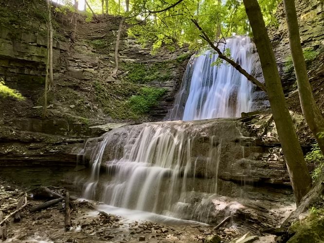
Just 0.4 km from the parking area lies Sherman Falls as it cascades down two tiers of bedrock along the Niagara Escarpment. The total height of the waterfalls is approximately 17 meters or 55-feet tall. The upper tier of Sherman Falls, being the taller of the two cascades, provides the most-scenic appeal but sits further back from the end of the trail. The lower tier sits right around where the trail ends, so you can get an up-close look at the waterfall. Sherman Falls is not a free-falling waterfall but rather a horsetail waterfall which maintains contact with the bedrock virtually at all times. Due to the contact, the noise level of Sherman Falls is a quiet constant rushing of water and makes for a peaceful and tranquil place to take a short hike. If you show up at the right time, you may even get this waterfall all to yourself like we did.
Hiking back from Sherman Falls is easy and relatively quick -- just follow the road back, but watch out for traffic along the way.
Parking
There's no parking near Old Dundas Road junction -- the only parking lot for this hike is located further down along Artaban Road. Hikers will find a medium-sized parking lot along Artaban Road at the coordinates provided. The lot is large enough to fit just over 1 dozen vehicles as of August 2024. The lot is used primarily as a way to explore the Dundas Valley section of the Hamilton Conservation Authority land.
Pets
Dogs are allowed only if leashed and must be cleaned up after.
Hike to Sherman Falls (Private Property)
This hike begins at a Hamilton Conservation Authority parking lot along Artaban Road where hikers will head south along the road to reach Lions Cub Road. The route leads to the main trailhead for Sherman Falls, located near the junction of Lions Cub Road and Old Dundas Road. The trail that leads to Sherman Falls is owned by a private entity as of August 2024 and they allow public access via the trail only. Please do not leave the trail. Hikers will find a separate trail on the east side of Ancaster Creek that leads to Sherman Falls but provides a different view. If you wish to explore the east side of the creek, please do so by hiking back to the road and up the other trail, despite the shortcut across the creek -- simply to obey the private land owner's wishes for liability reasons.
Sherman Falls - 0.4 km (0.25 miles)
Just 0.4 km from the parking area lies Sherman Falls as it cascades down two tiers of bedrock along the Niagara Escarpment. The total height of the waterfalls is approximately 17 meters or 55-feet tall. The upper tier of Sherman Falls, being the taller of the two cascades, provides the most-scenic appeal but sits further back from the end of the trail. The lower tier sits right around where the trail ends, so you can get an up-close look at the waterfall. Sherman Falls is not a free-falling waterfall but rather a horsetail waterfall which maintains contact with the bedrock virtually at all times. Due to the contact, the noise level of Sherman Falls is a quiet constant rushing of water and makes for a peaceful and tranquil place to take a short hike. If you show up at the right time, you may even get this waterfall all to yourself like we did.
Hiking back from Sherman Falls is easy and relatively quick -- just follow the road back, but watch out for traffic along the way.
Parking
There's no parking near Old Dundas Road junction -- the only parking lot for this hike is located further down along Artaban Road. Hikers will find a medium-sized parking lot along Artaban Road at the coordinates provided. The lot is large enough to fit just over 1 dozen vehicles as of August 2024. The lot is used primarily as a way to explore the Dundas Valley section of the Hamilton Conservation Authority land.
Pets
Dogs are allowed only if leashed and must be cleaned up after.