The Hike to Ball's Falls at Ball's Falls Conservation Area in Lincoln, Ontario is a moderate 4.4 km (2.7-mile) out-and-back hike that leads to two stunning waterfalls along the Niagara Escarpment, Upper and Lower Ball's Falls.
Trails
This hike follows several named trails in order from the trailhead to Upper Falls (Ball's Falls): Bruce Trail (white blazes) / Twenty Valley Trail, Cataract Trail / Upper Falls Side Trail (blue blazes).
Hike
This hike technically begins outside of the Ball's Falls Conservation Area and instead leads hikers along the Bruce Trail / Twenty Valley Trail (white blazes) to reach the conservation area. During our visit in August 2024, the main parking lot was full for a 5k race event, and I'm glad that we were able to explore the area by being forced to start at this trailhead. If you have limited time or can't hike the full length of the trail, you can always start at the conservation area instead.
Trailhead to Lower Falls - 0 to 1.3 km (0 to 0.8 miles)
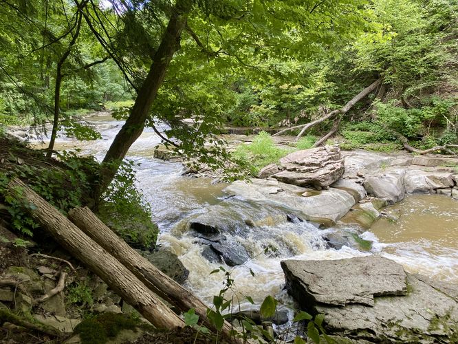
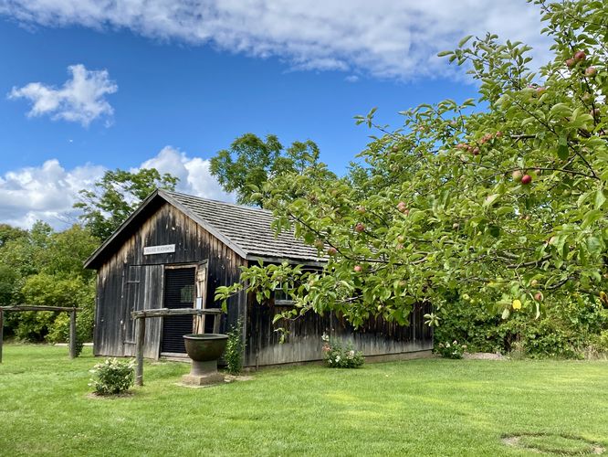
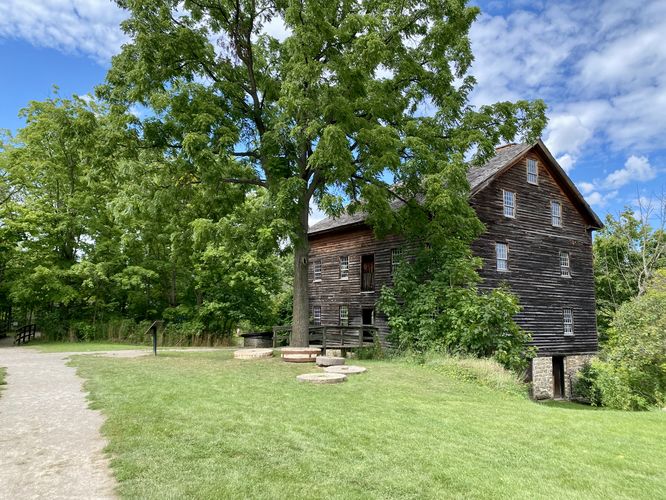
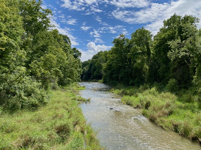
At the trailhead located on Glen Road, hikers will head downhill following the white blazes of the Bruce Trail where it uickly connects to the Twenty Valley Trail just down the hill. Keep-left at the junction to continue hiking south toward the conservation area. Along the way, hikers will be faced with an undulating very-rocky path that leads through the Twenty Mile Creek gorge. The steep slopes of the gorge, its evergreens, boulders and rocks make for a scenic hike as you make your way south. Around 0.87 km (0.55 miles), hikers will reach a bend in Twenty Mile Creek where you'll find a handful of very short waterfalls. This is a great spot to take a break and take-in the scenery of the creek and gorge. Just beyond the bend is a very-steep and long staircase that stretches out of the gorge and up to its rim. This staircase feels a bit sketchy as it has no landings, just keep going. At the top of the gorge, take a right-hand turn where the trail leads directly into the Ball's Falls Conservation Area. Hikers will pass through a section of the park with several historical buildings like an old blacksmith shop, cabin, mill, and more.
Lower Ball's Falls - 1.32 km (0.8 miles)
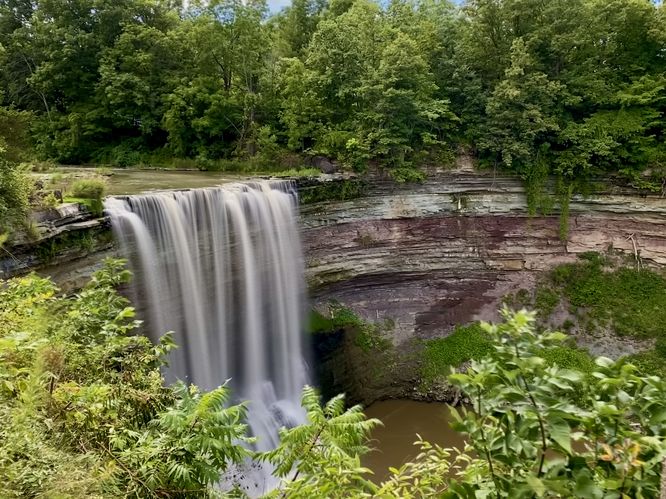
Follow the trail through the village to reach Lower Falls, located around 1.3 km (0.8 miles) from the trailhead. Lower Ball's Falls plummets in a free-falling cascade over a cliff within Twenty Mile Creek at approximately 27 meters (~90-feet) tall. Lower Falls (Lower Ball's Falls) is the tallest and most powerful waterfall along the hike -- visitors can appreciate its beauty from the fence line along the cliff.
Hiking to Upper Ball's Falls - 1.32 to 2.25 km (0.8 to 1.4 miles)
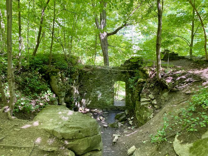
From Lower Ball's Falls, the Cataract Trail leads back through the village, crossing Sixth Ave, before it leads westward. The trail crosses a footbridge that spans Twenty Mile Creek before it leads further south. Along the way toward Upper Ball's Falls, hikers will pass a neat abandoned stone mill foundation around 2.1 km (1.3 miles) from the trailhead.
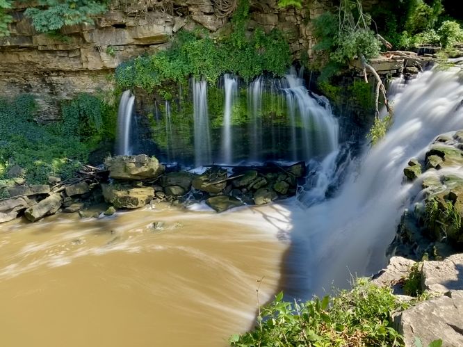
Upper Ball's Falls (Curtain Waterfall) - 2.25 km (1.4 miles)
Around 2.25 km (1.4-miles) from the trailhead, hikers will reach the stunning Upper Falls of Ball's Falls. This waterfall is another free-falling cascade that plummets over a cliff at approximately 10.7 meters (35-feet) tall. Upper Ball's Falls, as of August 2024, has a warp-around portion of the waterfall that sends water through cracks in the rocks where it's forced out of a large rock wall on the eastern side -- forming several waterfalls that cascade into the creek below. This type of waterfall is known as a "curtain waterfall". This natural formation is a unique feature of the Niagara Escarpment as the water's flow will eventually erode enough of the rocky cliff to create a landslide. As for now, this curtain waterfall is a unique sight to behold and makes for one of the best day hikes in the area.
Hiking Back - 2.25 to 4.4 km (1.4 to 2.7 miles)
The hike back to parking from Upper Ball's Falls is fairly straight forward -- just hike the same route back as you hiked in. You can spend a little bit of extra timing checking out Lower Falls once more, if you wish or stop by the bend in Twenty Mile Creek to appreciate the smaller cascades on your way out. Be sure to watch your step along the very-rocky gorge trail and mind your steps along the super-steep staircase that leads back down. Complete the route back at parking for a moderate 4.4 km (2.7-mile) out-and-back hike.
Parking
Hikers will find a large parking turnout at the coordinates provided, located on the north side of Glen Road in Lincoln, Ontario. The lot is large enough to fit over a dozen vehicles as of August 2024.
Pets
Dogs are allowed only if leashed and must be cleaned up after.
Warning
Steep cliffs: This hike leads to very-steep cliffs with sheer drop-offs. Watch your step and stay back from the cliff's edge for your own safety.
Trails
This hike follows several named trails in order from the trailhead to Upper Falls (Ball's Falls): Bruce Trail (white blazes) / Twenty Valley Trail, Cataract Trail / Upper Falls Side Trail (blue blazes).
Hike
This hike technically begins outside of the Ball's Falls Conservation Area and instead leads hikers along the Bruce Trail / Twenty Valley Trail (white blazes) to reach the conservation area. During our visit in August 2024, the main parking lot was full for a 5k race event, and I'm glad that we were able to explore the area by being forced to start at this trailhead. If you have limited time or can't hike the full length of the trail, you can always start at the conservation area instead.
Trailhead to Lower Falls - 0 to 1.3 km (0 to 0.8 miles)
At the trailhead located on Glen Road, hikers will head downhill following the white blazes of the Bruce Trail where it uickly connects to the Twenty Valley Trail just down the hill. Keep-left at the junction to continue hiking south toward the conservation area. Along the way, hikers will be faced with an undulating very-rocky path that leads through the Twenty Mile Creek gorge. The steep slopes of the gorge, its evergreens, boulders and rocks make for a scenic hike as you make your way south. Around 0.87 km (0.55 miles), hikers will reach a bend in Twenty Mile Creek where you'll find a handful of very short waterfalls. This is a great spot to take a break and take-in the scenery of the creek and gorge. Just beyond the bend is a very-steep and long staircase that stretches out of the gorge and up to its rim. This staircase feels a bit sketchy as it has no landings, just keep going. At the top of the gorge, take a right-hand turn where the trail leads directly into the Ball's Falls Conservation Area. Hikers will pass through a section of the park with several historical buildings like an old blacksmith shop, cabin, mill, and more.
Lower Ball's Falls - 1.32 km (0.8 miles)
Follow the trail through the village to reach Lower Falls, located around 1.3 km (0.8 miles) from the trailhead. Lower Ball's Falls plummets in a free-falling cascade over a cliff within Twenty Mile Creek at approximately 27 meters (~90-feet) tall. Lower Falls (Lower Ball's Falls) is the tallest and most powerful waterfall along the hike -- visitors can appreciate its beauty from the fence line along the cliff.
Hiking to Upper Ball's Falls - 1.32 to 2.25 km (0.8 to 1.4 miles)
From Lower Ball's Falls, the Cataract Trail leads back through the village, crossing Sixth Ave, before it leads westward. The trail crosses a footbridge that spans Twenty Mile Creek before it leads further south. Along the way toward Upper Ball's Falls, hikers will pass a neat abandoned stone mill foundation around 2.1 km (1.3 miles) from the trailhead.
Upper Ball's Falls (Curtain Waterfall) - 2.25 km (1.4 miles)
Around 2.25 km (1.4-miles) from the trailhead, hikers will reach the stunning Upper Falls of Ball's Falls. This waterfall is another free-falling cascade that plummets over a cliff at approximately 10.7 meters (35-feet) tall. Upper Ball's Falls, as of August 2024, has a warp-around portion of the waterfall that sends water through cracks in the rocks where it's forced out of a large rock wall on the eastern side -- forming several waterfalls that cascade into the creek below. This type of waterfall is known as a "curtain waterfall". This natural formation is a unique feature of the Niagara Escarpment as the water's flow will eventually erode enough of the rocky cliff to create a landslide. As for now, this curtain waterfall is a unique sight to behold and makes for one of the best day hikes in the area.
Hiking Back - 2.25 to 4.4 km (1.4 to 2.7 miles)
The hike back to parking from Upper Ball's Falls is fairly straight forward -- just hike the same route back as you hiked in. You can spend a little bit of extra timing checking out Lower Falls once more, if you wish or stop by the bend in Twenty Mile Creek to appreciate the smaller cascades on your way out. Be sure to watch your step along the very-rocky gorge trail and mind your steps along the super-steep staircase that leads back down. Complete the route back at parking for a moderate 4.4 km (2.7-mile) out-and-back hike.
Parking
Hikers will find a large parking turnout at the coordinates provided, located on the north side of Glen Road in Lincoln, Ontario. The lot is large enough to fit over a dozen vehicles as of August 2024.
Pets
Dogs are allowed only if leashed and must be cleaned up after.
Warning
Steep cliffs: This hike leads to very-steep cliffs with sheer drop-offs. Watch your step and stay back from the cliff's edge for your own safety.