Loading...

๐ŸŽ† 50% off 4th of July sale on Supporter Accounts โ€” now through July 6! Learn More.

Hidden Meadow Trail

Directions
Map
Pictures
Send to App
Distance:
2.5 Miles / 4.0 km
Type:
Out-and-Back
Difficulty:
Easy
Time to Hike:
1 hour, ~15 minutes
Features:
Surface Type:
Dirt
Park:
Glacier National Park
Town:
West Glacier, Montana
Directions:
48.748823, -114.249501
Added:
September 17, 2024
Updated:
September 30, 2024
Copy Trail Link Hiking this trail? Send a friend or family member a link to this trail guide for your own safety. Hike at your own risk (disclaimer)
Loading...
Loading...
244'

Total Change
284'

Ascent
284'

Descent

Download the Trail Route for Offline Use

Supporters get exclusive access to download trail routes to the MyHikes app for offline use. Stay prepared on your adventure, even without an internet connection! Become a Supporter today to unlock this feature and hike with confidence.

Send to App

Hidden Meadow Trail

The Hidden Meadow Trail at Glacier National Park near West Glacier, Montana is an easy 2.5-mile out-and-back hike that leads to a beautiful "hidden" meadow with views of a pond and distant mountains.

Hiking to Hidden Meadow

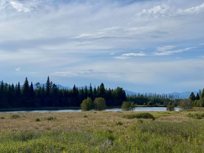
The hike out to Hidden Meadow is straight forward as the hike follows a single trail out-and-back. Hikers will begin at the main trailhead, located on the east side of the dirt road, North Fork Road. The Hidden Meadow Trail follows a moderate grade as it climbs uphill at just over 200-feet in elevation gain before it levels out for the remainder of the hike out to the meadow and water view. Along the way, you'll pass through a forest predominantly made-up of Western Larch and White Pine trees which appeared to be newer growth, as of the last 30 years or so. The forest is dense with white pine trees but every now and then you'll pass through sections of Quaking Aspen trees, with more aspen trees located closer to the meadow. The trail finally leads hikers out into the Hidden Meadow around mile 1.2 where you'll find a split in the trail -- this route follow both directions, however the first dead-ends with a decent view of the meadow ahead. The best view, however, is from further up on the hill -- located near the massive old-growth western red cedar tree. As of September 2024, the trail was a bit overgrown at the initial junction where you leave the woods, so push through the overgrowth (if need be) to head toward the large tree. From near the tree, hikers will find a view of the pond with jutting white spruce trees that adorn the skyline behind it. Hidden Meadow is significantly larger than we expected, so we did not hike out to the pond but rather enjoyed the views from the old growth. In the distance are mountain ranges that sit behind the scenic white spruce trees and provide a relaxing place for hikers to hang out or wait for wildlife to potentially pass by in search of a drink at the pond.

The hike back to parking is easy as it follows a mostly-flat undulating trail that eventually leads back downhill to the trailhead. Along the way, you can enjoy similar, but different views of the same Quaking Aspen trees on your way out. These trees are worth seeking out during Autumn as their leaves turn a vibrant yellow which sit juxtaposed to neighboring evergreen hemlock and spruce.

Vehicle Reservations

Depending on what time of year you visit, you may need to reserve a vehicle entrance pass to get into the park, in addition to a park entry fee (or annual National Parks pass). Before planning this hike, ensure you've checked the NPS website for when and where Glacier NP vehicle reservations are required.

Parking

Hikers will find just a few parking spots in two small turnouts by the trailhead, at the coordinates provided. The turnouts are large enough to fit just a handful of vehicles as of September 2024, however, this hike is not very popular which helps with parking.

Pets

Dogs are not allowed on any trails at Glacier National Park.

Warning

Grizzly bears: This trail is frequented often by grizzly bears, especially in late Summer and early Fall as they scrounge for 20 hours/day bulking for the winter. Always give wild animals plenty of space, including several hundred feet for grizzlies. It's best to bring bear spray on this hike as a last defense just in case a grizzly were to charge at you. Always make plenty of noise while hiking to alert animals to your presence long before you see them. It's also smart to hike with another person.
Explore 38 trails near West Glacier, MT
  1. Parking

    48.748823, -114.249501
  2. Main Trailhead

    48.748823, -114.249501
  3. View of Hidden Meadow pond

    48.756092, -114.230767
    View of Hidden Meadow pond
No community routes found. To add your own hike as a Community Route for this Trail guide, leave a Trip Report with an attached GPX file.

Seasons

Spring, Summer, Fall

Trip Reports

Trail Guide By:
Admin user profile picture
2.5 miles / 4.0 km
2.5 miles / 4.0 km
September 17, 2024
Hiking

Weather Forecast

In West Glacier, MT

Explore Hiking Trails

You May Also Like

Colorado's Million Dollar Highway - Plan a day's drive adventure along the iconic Million Dollar Highway in Colorado. Explore the best short trails, roadside stops, waterfalls, vistas, ghost towns, and hot springs within a ~6 hour road trip.
Explore

Colorado's Million Dollar Highway

Plan a day's drive adventure along the iconic Million Dollar Highway in Colorado. Explore the best short trails, roadside stops, waterfalls, vistas, ghost towns, and hot springs within a ~6 hour road trip.

Read
Glacier's Going-to-the-Sun Road - Discover the breathtaking beauty of Glacier National Park along the iconic Going-to-the-Sun Road. From stunning roadside stops to picturesque waterfalls and vistas, this engineering marvel offers endless opportunities for exploration.
Explore

Glacier's Going-to-the-Sun Road

Discover the breathtaking beauty of Glacier National Park along the iconic Going-to-the-Sun Road. From stunning roadside stops to picturesque waterfalls and vistas, this engineering marvel offers endless opportunities for exploration.

Read
New York's Best Waterfalls - Whether you're planning a day hike, roadside stop, or a leisurely short walk, this guide provides hikers, travelers, and locals alike with 63 different locations to over 100 scenic waterfalls to help plan your next adventure!
Explore

New York's Best Waterfalls

Whether you're planning a day hike, roadside stop, or a leisurely short walk, this guide provides hikers, travelers, and locals alike with 63 different locations to over 100 scenic waterfalls to help plan your next adventure!

Read

Before you boogie...

Find our trail guides useful? Consider becoming a Supporter to unlock perks!

MyHikes is an indie platform that makes exploring public trails easier for everyone. The platform has no investors, no ads, and is owned and operated by one person, Dave Miller. Dave has personally mapped and written over 1,800 trail guides on MyHikes for the public to explore. MyHikes has helped millions outdoor enthusiasts plan their next adventure.

But it takes a lot of time ๐Ÿ•ฆ, money ๐Ÿ’ฐ, work, and espresso shots โ˜• to run MyHikes, including hiking , mapping , writing , and publishing new trails with high-quality (accurate) information... along with software engineering (coding) the platform like building new features, website and mobile app development (iOS and Android), site maintainance . and much much more.

Supporters unlock website and mobile app perks with an annual one-time payment of $25 (you renew) ๐Ÿ˜Ž๐Ÿ‘. Or you can simply make a Donation of your choice. Otherwise, you can support us by telling your friends about MyHikes - both quick and free ๐ŸŽ‰

Admin user profile picture

Dave Miller
MyHikes Founder