The Henry's Woods Loop Hike at Adirondack Park near Lake Placid, New York is a moderate 3.6-mile hike that features beautiful views of Mirror Lake and Lake Placid with their surrounding mountains.
Trail names: Connector Trail,Loop Trail, Rocky Knob Trail, Plateau Trail
Location: 20 Bear Cub Road, Lake Placid, NY
Permitted uses: Hiking, Running, Non motorized biking, skiing, Snowshoeing
Prohibited uses: No use of any motorized vehicles, No Horseback riding, No fires, No camping, No overnight visits, No smoking, No alcohol use, No removal of plants, animals, rocks or firewood, No broadcast sounds, No off trail hiking, During winter do not walk in ski tracks.
Hours: Daylight use only
Fees and Parking: There is no fee to park or use the trails There are two entrances to the parking area with plenty of off street parking. The parking is less like a lot and more like a road that forms a semicircle.
Pets: Aggressive dogs or dogs in heat are not allowed. No more than 3 dogs per person/party. All dogs must have a valid license and be vaccinated for rabies with visible tags displayed on the dog's collars. Owners must carry a leash with them at all times. Dogs must be in sight and under voice control at all times. Dogs must be immediately leashed at the first sign of aggressive behavior. If any unfortunate incidents occur involving dog aggression, owners must cooperate with any investigation into the matter and take full responsibility for any injury or damage caused by their dog's actions. All dog waste must be removed by the owner and not left on the trail. There are dog waste bags available at the trailhead.
Accessibility: The trails are not wheelchair accessible. The only possible exception would be the Connector Trail that has a crushed stone surface. This part of the trail is fairly flat and is approximately 5 feet wide. However, the trail is only .3 of a mile one way.
Hiker amenities: There is an information kiosk 100 feet from the trail entrance. There is a posted map at the kiosk as well as information on each trail's length, challenge level and elevation gain. There is also a brief synopsis of each trail's features or points of interest. There are no restrooms and no trash bins. Please pack out all the trash you bring, make or find.
Length and Trail information: This hike was done as a loop, is approximately 3.6 miles long and is an easy hike. The only mildly strenuous part of the hike was the ascent up the Rocky Knob that has a summit located at 2,270 feet above sea level, but only has an elevation gain of about 320 feet. There are currently 5 trails at this preserve. Each Trail has a different color trail marker. All the trails are well marked, well maintained and well blazed. This is the first preserve that I have visited that had such a detailed dog policy posted. My guess is there may have been a previous unfortunate dog incident, because the dog policy is very comprehensive.
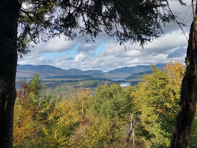
Our goal for this hike was to take a relaxing hike, explore the Preserve and reach the summit on the Rocky Knob Trail. We were interested in seeing how nice the views were and if we would see any colors of the changing foliage in the valley below.
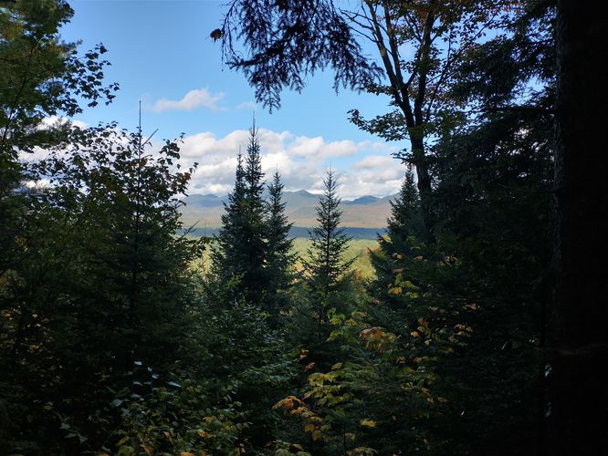
The first trail all visitors will take from the parking area is the Connector Trail. The Connector Trail is blazed by green markers and is wide and flat with a packed crushed stone substrate. Either side is sheltered by a densely growing wooded forest. This preserve is next to private land and there are several signs posted encouraging visitors to stay on marked trails only. From the Short Connector Trail, hikers will travel either South or West on the Loop Trail. We went west. The Loop Trail has green blazes and a bit more incline as you travel through the woods. One of the odd, but interesting features along the Loop Trail is a suspension bridge that was installed as part of an Eagle Scout project in 2023. The bridge is aptly named “ The Bridge to Nowhere” and the views after crossing over it are of a small rocky trickling brook beside a wooded embankment. The views may not be interesting, but if you have any curiosity about suspension bridges you will be able to get a close up view of this one's construction. From the Loop Trail we headed Northwest and began our ascent to the summit on the Rocky Knob Trail. The substrate is narrower, and a bit more wild compared to the Connector and Loop Trails. There are rocks and roots to navigate, so more caution is needed on this trail. This trail is blazed in red and offers some nice, albeit limited views of the Lake Placid area, just before reaching the summit. After enjoying the views here, we continued on past the summit to enjoy the limited views of the Great Range in the other direction. We then began our descent until we once again reached the Loop Trail. At this point we could have headed Northeast back along the Loop Trail to the parking area, but instead headed South to extend our hike. We hiked to the first junction of the Plateau Trail. The Plateau Trail is marked in yellow markers. Along the Plateau Trail there are a couple of benches installed at two steps where visitors will be able to see limited views of the Sentinel Range as well as the Wilmington Notch. We hiked north until we reached the junction of the Switchback Trail. We did not hike the Switchback Trail, instead we continued on the Plateau Trail southward until the trail intersected with the Loop Trail once again and headed east. From that intersection, we hiked north back on the Loop Trail toward the Connector Trail and on to the parking area. Along this section of the Loop Trail , it is s very important not to wander off the trail. There were signs posted that warned of a Live Fire Shooting area, and some of the signage needed replacing. Stay safe, and stay on the trail.
We enjoyed our hike In Henry's Woods and we're pleased to know that this beautiful place exists, not just to the benefit of residents, but to visitors like us. The trails at Henry's Woods are well marked, well maintained. This lovely trail system allowed us a relaxing day of hiking in the beautiful Adirondack Mountains and we would recommend it to all fellow hikers.
History: Henry's Woods is a 212 acre forest preserve that was officially opened
and dedicated to the memory of Henry Uihlein in September of 2009.
Interestingly, Mr. Uihlein played a significant role in bringing the
Olympics to Lake Placid in 1932 and was an active supporter of the 1980
Winter Olympics as well. He was a great philanthropist and supported
many great causes including the Eisenhower Medical Center, Mayo Clinic,
the Uihlein Mercy Center and the Cornell College of Agriculture.The
preserve is maintained by The Henry Uihlein II and Mildred A. Uihlein
Foundation.