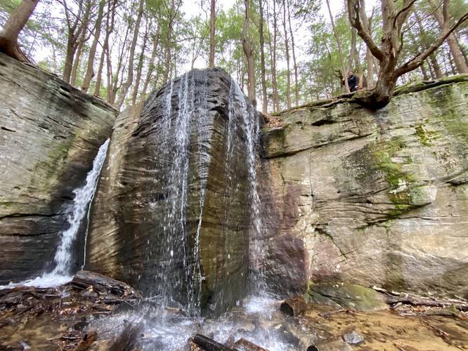
The Hector Falls Trail at Allegheny National Forest near Sheffield, Pennsylvania is an easy 2.1-mile out-and-back trail that leads to the beautiful but popular waterfall, Hector Falls. Hector Falls is about 20-feet tall and cascades water down two sides of a massive rock that's located within a scenic boulder ravine.
This trail follows a service road for about 0.8 miles, heading downhill the entire time, to a small blue pipe that appears to be related to a natural gas well. The service road is wide enough for a vehicle, however, only foot traffic is allowed on this trail.
Once hikers reach the blue gas well pipe, the wide service road trail ends and the skinnier and muddier forest trail begins. This trail then leads along a creek and through a conifer forest toward Hector Falls. Hector Falls sits just a short distance, about 0.3-miles, from where the service road ends and the forest trail begins.
Once you reach Hector Falls, the trail heads down the right-hand side of the creek, passing massive boulders before crossing the creek. The creek crossing is fairly sketchy because the only way across is by following some large branches that hikers placed to make a make-shift bridge. After crossing the creek once, you'll get a great view of Hector Falls from about 40-feet away.
The best shots of Hector Falls are from directly below - requiring yet another creek crossing. There's a tree growing out of a large boulder in the middle of the creek - hikers can use this boulder as a way to get across the creek, using smaller rocks as stepping stones in between. Once at the other side, hike up to the base of Hector Falls for the best view.
Hiking back from the falls is the same as the hike in, but the way back is mostly all uphill.
Parking
Hikers will find a small parking lot next to the service road gate at the coordinates provided. The lot fills up quickly on weekends, so hikers can park alongside the road as well.
Road Conditions
Parking for the waterfall lies off of a forest road that is often not maintained during the winter (i.e. plowed). Also note that this dirt road can be extremely muddy, with plenty of ruts created from previous drivers. Do not attempt to drive down this road if the road is totally washed out as your vehicle might get stuck. Drive at your own risk.
Pets
Dogs are allowed if leashed.
Water Source
Please note that backpackers can filter the water along this creek, but it is not advised because of the natural gas extraction that litters Allegheny National Forest. Hikers take chances filtering water here, unless in desperate need, because of the potential for contaminants in the water despite having a world-class water filter.
Camping
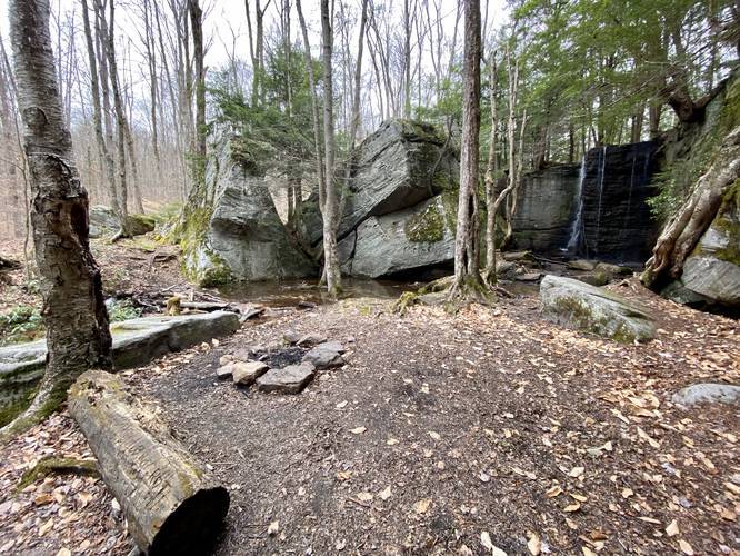
Backpackers can camp off of this trail but must follow the National Forest dispersed/primitive/backcountry camping rules. There's a small fire pit just below Hector Falls with a view of the waterfall. National Forest regulations likely discourage camping along creeks unless there's a predefined campsite. We listed this fire pit as a campsite, but backpackers and campers must check the Allegheny National Forest rules.
Warning
Crossing the creek to view Hector Falls is not easy and is a bit dangerous. At the very least, you may get your feet wet or you may fall into the creek. Note that there are plenty of large rocks in/around the creek crossings, so watch your step. Additionally, the 20-foot tall cliffs around Hector Falls are dangerous as well are the small caves found within the boulders near the waterfall. Hike at your own risk.
This trail follows a service road for about 0.8 miles, heading downhill the entire time, to a small blue pipe that appears to be related to a natural gas well. The service road is wide enough for a vehicle, however, only foot traffic is allowed on this trail.
Once hikers reach the blue gas well pipe, the wide service road trail ends and the skinnier and muddier forest trail begins. This trail then leads along a creek and through a conifer forest toward Hector Falls. Hector Falls sits just a short distance, about 0.3-miles, from where the service road ends and the forest trail begins.
Once you reach Hector Falls, the trail heads down the right-hand side of the creek, passing massive boulders before crossing the creek. The creek crossing is fairly sketchy because the only way across is by following some large branches that hikers placed to make a make-shift bridge. After crossing the creek once, you'll get a great view of Hector Falls from about 40-feet away.
The best shots of Hector Falls are from directly below - requiring yet another creek crossing. There's a tree growing out of a large boulder in the middle of the creek - hikers can use this boulder as a way to get across the creek, using smaller rocks as stepping stones in between. Once at the other side, hike up to the base of Hector Falls for the best view.
Hiking back from the falls is the same as the hike in, but the way back is mostly all uphill.
Parking
Hikers will find a small parking lot next to the service road gate at the coordinates provided. The lot fills up quickly on weekends, so hikers can park alongside the road as well.
Road Conditions
Parking for the waterfall lies off of a forest road that is often not maintained during the winter (i.e. plowed). Also note that this dirt road can be extremely muddy, with plenty of ruts created from previous drivers. Do not attempt to drive down this road if the road is totally washed out as your vehicle might get stuck. Drive at your own risk.
Pets
Dogs are allowed if leashed.
Water Source
Please note that backpackers can filter the water along this creek, but it is not advised because of the natural gas extraction that litters Allegheny National Forest. Hikers take chances filtering water here, unless in desperate need, because of the potential for contaminants in the water despite having a world-class water filter.
Camping
Backpackers can camp off of this trail but must follow the National Forest dispersed/primitive/backcountry camping rules. There's a small fire pit just below Hector Falls with a view of the waterfall. National Forest regulations likely discourage camping along creeks unless there's a predefined campsite. We listed this fire pit as a campsite, but backpackers and campers must check the Allegheny National Forest rules.
Warning
Crossing the creek to view Hector Falls is not easy and is a bit dangerous. At the very least, you may get your feet wet or you may fall into the creek. Note that there are plenty of large rocks in/around the creek crossings, so watch your step. Additionally, the 20-foot tall cliffs around Hector Falls are dangerous as well are the small caves found within the boulders near the waterfall. Hike at your own risk.