The Halfmoon Mountain Loop at the George Washington and Jefferson National Forest near Wardensville, West Virginia is a difficult 8.9-mile loop hike that features four vista points - including the Halfmoon Lookout with sweeping views of the Trout Run Valley - and features plenty of backcountry campsites for backpacking.
Trails
This hike follows several named trails: Pond Run Trail - blue blazes, Halfmoon Trail - yellow blazes, Halfmoon Lookout Trail - black blazes, German Wilson Trail - pink blazes, Bucktail Trail - orange blazes, and finally the County Road 5/1 that leads back to parking.
Hike Description
Please note that this GPS track begins and ends at a parking area and follows the road over to the trailhead, so the mileage between trail junctions will vary based on where you begin tracking your own hike along this loop.
Hikers will begin by following the blue blazes of the Pond Run Trail - a section of the Tuscarora Trail - for just over 2.5-miles gradually uphill along Waites Run creek and Pond Run creek that flows into Waites. This section of the hike has a couple of steeper grade inclines, but for the most part is no more than a moderate climb up the mountain. This section of the hike requires about 4 or 5 creek crossings, which are easy in late Spring or the Summer.
Hidden Vista at Halfmoon Trail Junction
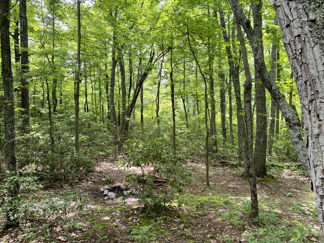
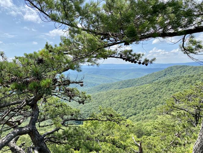
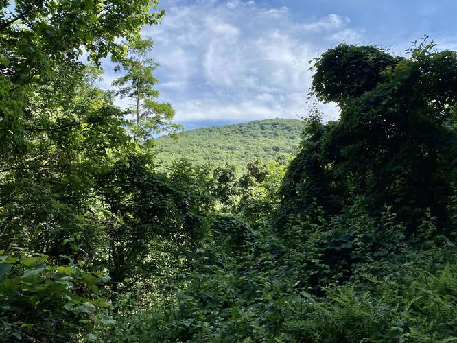
Around mile 3 in the GPS track - where the Pond Run Trail (blue blazes) meets the Halfmoon Trail (yellow blazes) - is a vista point tucked away behind a large campsite. An unofficial trail leads about 100-yards from the campsite to the vista. The vista gives hikers a view of Halfmoon Mountain to the right-hand side and part of Trout Run Valley below. While this vista is not as stunning as the Halfmoon Lookout vistas, it's a really nice quiet place to take a break before hiking into the more-crowded Halfmoon Mountain.
Reaching the Halfmoon Lookout Trail
Continuing on from the hidden vista, hikers will head northeast along the yellow blazes of the Halfmoon Trail. Around 0.5-miles from the junction of the Pond Run Trail and the Halfmoon Trail is the Halfmoon Lookout Trail - a spur trail that leads up to the summit of Halfmoon Mountain. Stay right to keep on the Halfmoon Lookout Trail. Once on the Halfmoon Lookout Trail, the hike to reach the last two vistas is fairly easy, but the elevation grade of the trail increases slightly. Here, the trail becomes a bit more crowded as this section is only an out-and-back and is usually the final destination for most hikers headed to Halfmoon Mountain.
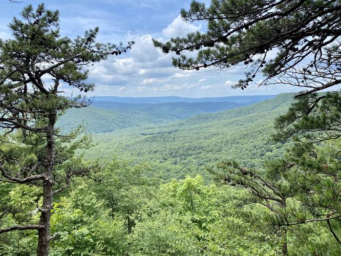
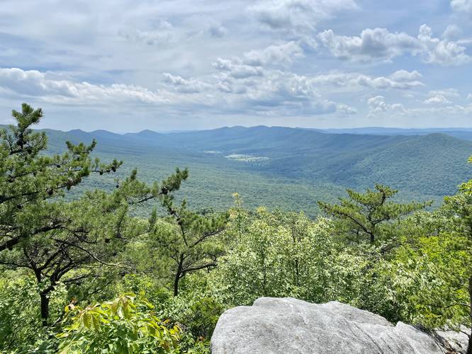
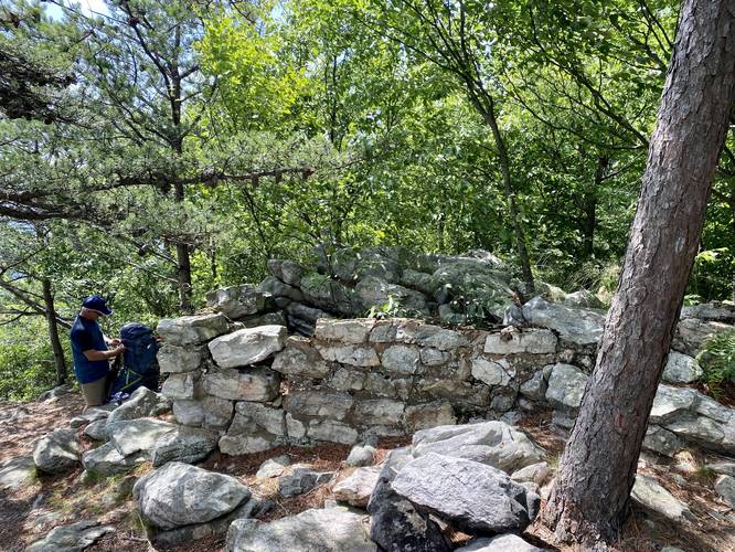
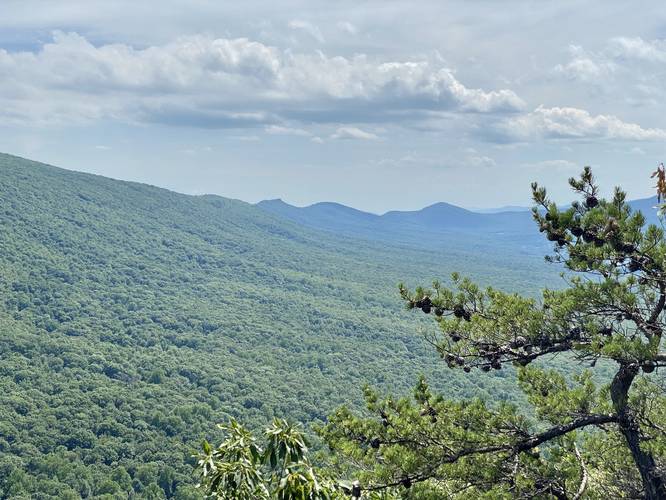
Halfmoon Lookouts and Fire Tower Site
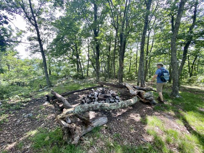
The last 100-feet climbing the trail to reach the vistas is a bit rocky, so watch your step. Before you reach the first vista (also the best, in my opinion) is an old rock foundation - this is the site of an old fire tower that was taken down in the 1960's when the forestry department switched to using satellites to monitor forest fires. Finally, sitting behind the old fire tower site is the Halfmoon Lookout with enough space for several people to sit and enjoy sweeping views of the Trout Run Valley below. Hikers will also find another vista located on the other side of the mountain summit, by hiking down into the campsite at the summit and up over to the westerly vista. This saddle of a hike at the summit is the "halfmoon" which the mountain is named after. The westerly vista is not as nice as the first vista near the fire tower, but is still worth checking out nonetheless. The campsite at the summit is a great place to stay for sunrises and sunsets; however, the summit does get busy and there are no water sources near the the campsite.
Hiking Out
Before heading out note that just below the summit of Halfmoon Mountain is another campsite with another vista point tucked away behind it. After visiting the Halfmoon Mountain summit and the vistas, hikers will want to complete their loop by first heading out along the Halfmoon Lookout Trail to reach the German Wilson Trail (pink blazes). Take a left-hand turn along the German Wilson Trail to head down the mountain along a steeper-grade trail. While the elevation grade of the German Wilson is not easy, it does allow you to descend the mountain quickly before reaching the more gradual Bucktail Trail (orange blazes) - which is essentially a service road for forestry workers. There's not much to see along either the German Wilson Trail nor the Bucktail Trail, but the German Wilson does have a campsite and the Bucktail Trail has a small creek for filtering water.
Eventually, the Bucktail Trail will reach the County Road 1/5 where you can take a right-hand turn, hike for about 0.6-miles, before reaching the parking area once again.
Parking
Hikers will find a couple of parking turnouts along County Road 1/5 near the coordinates provided.
Camping and Backpacking
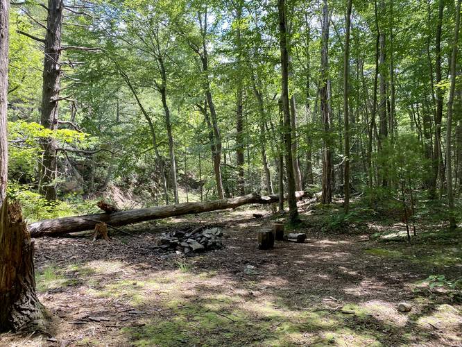
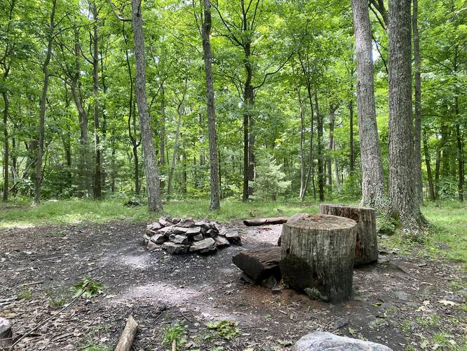
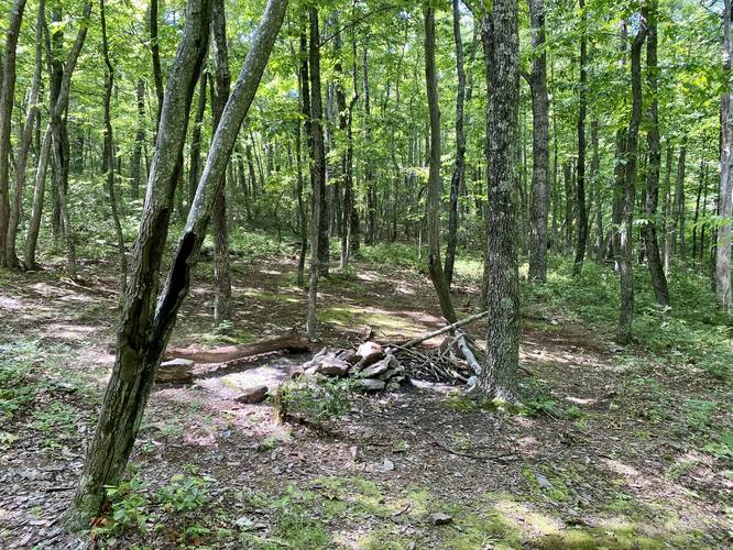
Backpackers will find plenty of campsites located just off-trail on almost all of the trails along this loop. The best campsites can be found near the top of Halfmoon Lookout, but that area gets busy with day hikers. There's a campsite that sits between the two Halfmoon Lookouts, while another more tucked-away campsite sits just below the summit. Please follow all National Forest dispersed / backcountry / primitive camping rules while camping and backpacking here.
Warnings
Rattlesnakes: Rattlers can be found in the forest along these trails, especially in places where they can sun themselves (rocky outcroppings) or cool down for a drink (near the streams), or both. Be on the lookout and bring trekking poles or a hiking pole to aid in finding rattlers before your feet do.
Poison Ivy: Hikers should watch out for poison ivy that grows on the sides of the trails and up the trees.
Water Sources, Waterfall Cascades, and Creek Crossings
This hike follows Waites Run creek and Pond Run creek along the Pond Run Trail, which allows for water filtration. Additionally, hikers will need to cross the creek several times, which may be more annoying during the early Spring. Hikers will find some very small waterfall cascades - no larger than 2 or 3-feet tall, and a lot of slide waterfalls - along Waites Run and Pond Run creek that feeds into Waites Run. None of the waterfalls were really worth photographing. The only other place for water is along the Bucktail trail where a small creek flows down the mountain near the junction with the Germain Wilson Trail.
Trails
This hike follows several named trails: Pond Run Trail - blue blazes, Halfmoon Trail - yellow blazes, Halfmoon Lookout Trail - black blazes, German Wilson Trail - pink blazes, Bucktail Trail - orange blazes, and finally the County Road 5/1 that leads back to parking.
Hike Description
Please note that this GPS track begins and ends at a parking area and follows the road over to the trailhead, so the mileage between trail junctions will vary based on where you begin tracking your own hike along this loop.
Hikers will begin by following the blue blazes of the Pond Run Trail - a section of the Tuscarora Trail - for just over 2.5-miles gradually uphill along Waites Run creek and Pond Run creek that flows into Waites. This section of the hike has a couple of steeper grade inclines, but for the most part is no more than a moderate climb up the mountain. This section of the hike requires about 4 or 5 creek crossings, which are easy in late Spring or the Summer.
Hidden Vista at Halfmoon Trail Junction
Around mile 3 in the GPS track - where the Pond Run Trail (blue blazes) meets the Halfmoon Trail (yellow blazes) - is a vista point tucked away behind a large campsite. An unofficial trail leads about 100-yards from the campsite to the vista. The vista gives hikers a view of Halfmoon Mountain to the right-hand side and part of Trout Run Valley below. While this vista is not as stunning as the Halfmoon Lookout vistas, it's a really nice quiet place to take a break before hiking into the more-crowded Halfmoon Mountain.
Reaching the Halfmoon Lookout Trail
Continuing on from the hidden vista, hikers will head northeast along the yellow blazes of the Halfmoon Trail. Around 0.5-miles from the junction of the Pond Run Trail and the Halfmoon Trail is the Halfmoon Lookout Trail - a spur trail that leads up to the summit of Halfmoon Mountain. Stay right to keep on the Halfmoon Lookout Trail. Once on the Halfmoon Lookout Trail, the hike to reach the last two vistas is fairly easy, but the elevation grade of the trail increases slightly. Here, the trail becomes a bit more crowded as this section is only an out-and-back and is usually the final destination for most hikers headed to Halfmoon Mountain.
Halfmoon Lookouts and Fire Tower Site
The last 100-feet climbing the trail to reach the vistas is a bit rocky, so watch your step. Before you reach the first vista (also the best, in my opinion) is an old rock foundation - this is the site of an old fire tower that was taken down in the 1960's when the forestry department switched to using satellites to monitor forest fires. Finally, sitting behind the old fire tower site is the Halfmoon Lookout with enough space for several people to sit and enjoy sweeping views of the Trout Run Valley below. Hikers will also find another vista located on the other side of the mountain summit, by hiking down into the campsite at the summit and up over to the westerly vista. This saddle of a hike at the summit is the "halfmoon" which the mountain is named after. The westerly vista is not as nice as the first vista near the fire tower, but is still worth checking out nonetheless. The campsite at the summit is a great place to stay for sunrises and sunsets; however, the summit does get busy and there are no water sources near the the campsite.
Hiking Out
Before heading out note that just below the summit of Halfmoon Mountain is another campsite with another vista point tucked away behind it. After visiting the Halfmoon Mountain summit and the vistas, hikers will want to complete their loop by first heading out along the Halfmoon Lookout Trail to reach the German Wilson Trail (pink blazes). Take a left-hand turn along the German Wilson Trail to head down the mountain along a steeper-grade trail. While the elevation grade of the German Wilson is not easy, it does allow you to descend the mountain quickly before reaching the more gradual Bucktail Trail (orange blazes) - which is essentially a service road for forestry workers. There's not much to see along either the German Wilson Trail nor the Bucktail Trail, but the German Wilson does have a campsite and the Bucktail Trail has a small creek for filtering water.
Eventually, the Bucktail Trail will reach the County Road 1/5 where you can take a right-hand turn, hike for about 0.6-miles, before reaching the parking area once again.
Parking
Hikers will find a couple of parking turnouts along County Road 1/5 near the coordinates provided.
Camping and Backpacking
Backpackers will find plenty of campsites located just off-trail on almost all of the trails along this loop. The best campsites can be found near the top of Halfmoon Lookout, but that area gets busy with day hikers. There's a campsite that sits between the two Halfmoon Lookouts, while another more tucked-away campsite sits just below the summit. Please follow all National Forest dispersed / backcountry / primitive camping rules while camping and backpacking here.
Warnings
Rattlesnakes: Rattlers can be found in the forest along these trails, especially in places where they can sun themselves (rocky outcroppings) or cool down for a drink (near the streams), or both. Be on the lookout and bring trekking poles or a hiking pole to aid in finding rattlers before your feet do.
Poison Ivy: Hikers should watch out for poison ivy that grows on the sides of the trails and up the trees.
Water Sources, Waterfall Cascades, and Creek Crossings
This hike follows Waites Run creek and Pond Run creek along the Pond Run Trail, which allows for water filtration. Additionally, hikers will need to cross the creek several times, which may be more annoying during the early Spring. Hikers will find some very small waterfall cascades - no larger than 2 or 3-feet tall, and a lot of slide waterfalls - along Waites Run and Pond Run creek that feeds into Waites Run. None of the waterfalls were really worth photographing. The only other place for water is along the Bucktail trail where a small creek flows down the mountain near the junction with the Germain Wilson Trail.