The Halemau'u Trail to Haleakala Crater Lookout is an easy to moderate 1.6-mile out-and-back hike that leads out to a stunning view of the Haleakala Crater from the west side of the crater.
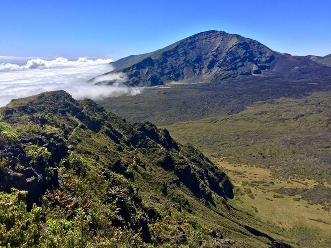
The trail begins at the trailhead at the parking coordinates provided and heads downhill along a gradual grade for about 0.8-miles before reaching one switchback which leads to the edge of the crater with absotlutely stunning views of the old lava flow and a peak into the crater from the northwestern corner of the crater.
The hike in is not very interesting since you'll be hiking along low-growth shrubs with minimal views along the way. Once you get about 0.6 to 0.7-miles into the hike, you'll finally get some peaks of the clouds below you and various hills along the slopes of Haleakala facing north.
Once you reach the lookout point, you must be extremely careful not to trip and fall - or you will fall hundreds of feet into the crater floor below, that is, if you're lucky, since the crater descent is really closer to 2,000-feet. Stand far back from the edge and enjoy the amazing views of the clouds reaching toward the top of Haleakala. On good days, the clouds won't roll in and they'll stay well below the elevation of the trail.
The hike back is not very difficult unless you have not acclimated to the elevation. It's about 300-feet elevation gain on the hike back to parking, but over 0.8-miles.
Important note: Please note that this is just a small section of the Halemau'u Trail and this leads down the first switchback to the first lookout point at the edge of the Haleakala Crater. If you plan to hike into the crater via the Halemau'u Trail, you'll descent about 2,000-feet into the crater along a dozen or more switchbacks before reaching the crater floor. The crater hike is a much different hike than this hike, so please be prepared and do your research on the dangers of hiking to the crater floor.
Elevation and Difficulty: This hike is rated as easy, but can be considered moderate for one main reason - the elevation. This trail sits at about 8,000-feet above sea level and most people drive up from sea level and do not acclimate to the thin air before hiking. The trail's actual elevation gain is about 300-feet over 0.8-miles on the hike back, but the hike is moderate for those who do not acclimate well or have a hard time breathing. Make sure to spend about 30 minutes walking around the parking lot before attempting any hikes. You may find it more difficult to breathe while exerting more energy at these altitudes.
Fees: There's a $25 entry fee for Haleakala National Park. The ticket you receive is good for 7-days (make sure to check the Haleakala National Park's site), but I highly encourage you to purchase the $50 annual pass if you plan to visit more national parks within the next 365 days.
Respecting the Land
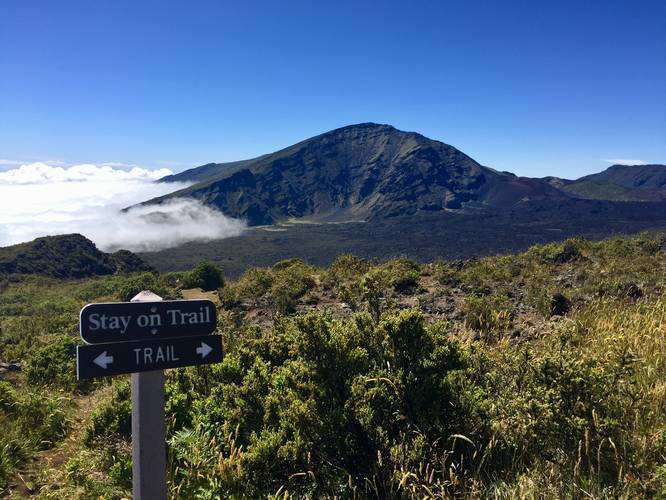
Hawaiian land is considered sacred to native Hawaiians and many locals, so please stay on-trail, take nothing but photos, and leave nothing but footprints. Respect the locals - don't stay for long and have a backup hike planned in case the parking lot is full.
The trail begins at the trailhead at the parking coordinates provided and heads downhill along a gradual grade for about 0.8-miles before reaching one switchback which leads to the edge of the crater with absotlutely stunning views of the old lava flow and a peak into the crater from the northwestern corner of the crater.
The hike in is not very interesting since you'll be hiking along low-growth shrubs with minimal views along the way. Once you get about 0.6 to 0.7-miles into the hike, you'll finally get some peaks of the clouds below you and various hills along the slopes of Haleakala facing north.
Once you reach the lookout point, you must be extremely careful not to trip and fall - or you will fall hundreds of feet into the crater floor below, that is, if you're lucky, since the crater descent is really closer to 2,000-feet. Stand far back from the edge and enjoy the amazing views of the clouds reaching toward the top of Haleakala. On good days, the clouds won't roll in and they'll stay well below the elevation of the trail.
The hike back is not very difficult unless you have not acclimated to the elevation. It's about 300-feet elevation gain on the hike back to parking, but over 0.8-miles.
Important note: Please note that this is just a small section of the Halemau'u Trail and this leads down the first switchback to the first lookout point at the edge of the Haleakala Crater. If you plan to hike into the crater via the Halemau'u Trail, you'll descent about 2,000-feet into the crater along a dozen or more switchbacks before reaching the crater floor. The crater hike is a much different hike than this hike, so please be prepared and do your research on the dangers of hiking to the crater floor.
Elevation and Difficulty: This hike is rated as easy, but can be considered moderate for one main reason - the elevation. This trail sits at about 8,000-feet above sea level and most people drive up from sea level and do not acclimate to the thin air before hiking. The trail's actual elevation gain is about 300-feet over 0.8-miles on the hike back, but the hike is moderate for those who do not acclimate well or have a hard time breathing. Make sure to spend about 30 minutes walking around the parking lot before attempting any hikes. You may find it more difficult to breathe while exerting more energy at these altitudes.
Fees: There's a $25 entry fee for Haleakala National Park. The ticket you receive is good for 7-days (make sure to check the Haleakala National Park's site), but I highly encourage you to purchase the $50 annual pass if you plan to visit more national parks within the next 365 days.
Respecting the Land
Hawaiian land is considered sacred to native Hawaiians and many locals, so please stay on-trail, take nothing but photos, and leave nothing but footprints. Respect the locals - don't stay for long and have a backup hike planned in case the parking lot is full.