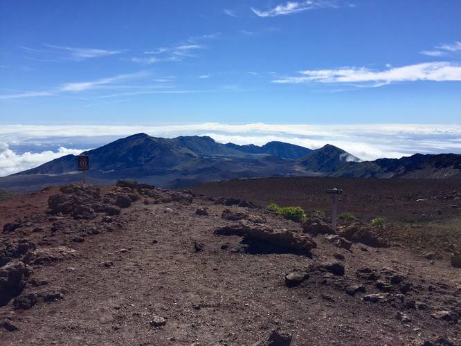
The Red Hill Summit Trail at Haleakala National Park in Maui, Hawaii is an easy 0.3 mile loop trail that sits at 10,023 feet at its highest point and is also the highest point on Maui.
From this summit trail you get stunning views of the entire west Maui, Haleakala Crater, and the Haleakala Observatory. Walking can be difficult at 10,000 feet due to the lack of oxygen, so it's advised to take it slow. You can use this trail to help acclimate to the altitude if you're planning to hike into the crater via the Keonehe'ehe'e (Sliding Sands) Trail.
Night Sky: The Haleakala Summit is the 4th darkest place in the world due to the lack of light pollution and atmosphere, which makes it a perfect spot to shoot the milky way and other celestial objects. The Haleakala Observatory can also be found near the summit and has been used for astrophysical experiments by the University of Hawaii and other organizations for decades.
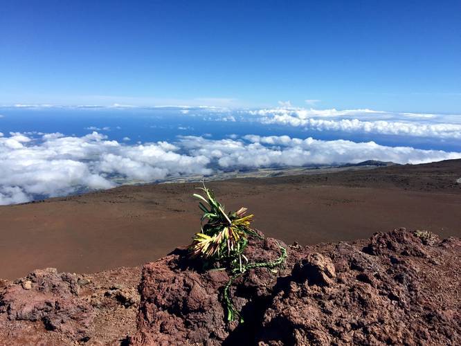
'Ahinahina (Silversword): The rare plant known as the Silversword is one of the only plants that grows in the Haleakala desert and nowhere else on the planet. They live up to about 50 years old, if not older, and only flower once in their lifetime. After flowering, they scatter up to 50,000 seeds and then die - turning into a reflective silver-like sword left over. These plants were believed to evolved from a California tarweed that arrived on the island millions of years ago - perhaps hitchhiking on a bird. Today, it's an endangered species and trampling on the roots can cause serious harm to the plants. Stay away from the plants and stay on the trail - despite seeing a lot of hikers getting too close to the plants for pictures.
Fees: There's a $25 entry fee for Haleakala National Park. The ticket you receive is good for 7-days (make sure to check the Haleakala National Park's site), but I highly encourage you to purchase the $50 annual pass if you plan to visit more national parks within the next 365 days.
Respecting the Land
Hawaiian land is considered sacred to native Hawaiians and many locals, so please stay on-trail, take nothing but photos, and leave nothing but footprints. Respect the locals - don't stay for long and have a backup hike planned in case the parking lot is full.
From this summit trail you get stunning views of the entire west Maui, Haleakala Crater, and the Haleakala Observatory. Walking can be difficult at 10,000 feet due to the lack of oxygen, so it's advised to take it slow. You can use this trail to help acclimate to the altitude if you're planning to hike into the crater via the Keonehe'ehe'e (Sliding Sands) Trail.
Night Sky: The Haleakala Summit is the 4th darkest place in the world due to the lack of light pollution and atmosphere, which makes it a perfect spot to shoot the milky way and other celestial objects. The Haleakala Observatory can also be found near the summit and has been used for astrophysical experiments by the University of Hawaii and other organizations for decades.
'Ahinahina (Silversword): The rare plant known as the Silversword is one of the only plants that grows in the Haleakala desert and nowhere else on the planet. They live up to about 50 years old, if not older, and only flower once in their lifetime. After flowering, they scatter up to 50,000 seeds and then die - turning into a reflective silver-like sword left over. These plants were believed to evolved from a California tarweed that arrived on the island millions of years ago - perhaps hitchhiking on a bird. Today, it's an endangered species and trampling on the roots can cause serious harm to the plants. Stay away from the plants and stay on the trail - despite seeing a lot of hikers getting too close to the plants for pictures.
Fees: There's a $25 entry fee for Haleakala National Park. The ticket you receive is good for 7-days (make sure to check the Haleakala National Park's site), but I highly encourage you to purchase the $50 annual pass if you plan to visit more national parks within the next 365 days.
Respecting the Land
Hawaiian land is considered sacred to native Hawaiians and many locals, so please stay on-trail, take nothing but photos, and leave nothing but footprints. Respect the locals - don't stay for long and have a backup hike planned in case the parking lot is full.