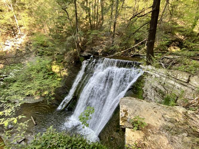
Gully Falls (Yellow Trail) at The Gully Preserve in Wayland, New York is a moderate 0.3-mile out-and-back hike that leads to the beautiful 45-foot tall Gully Falls.
Trails
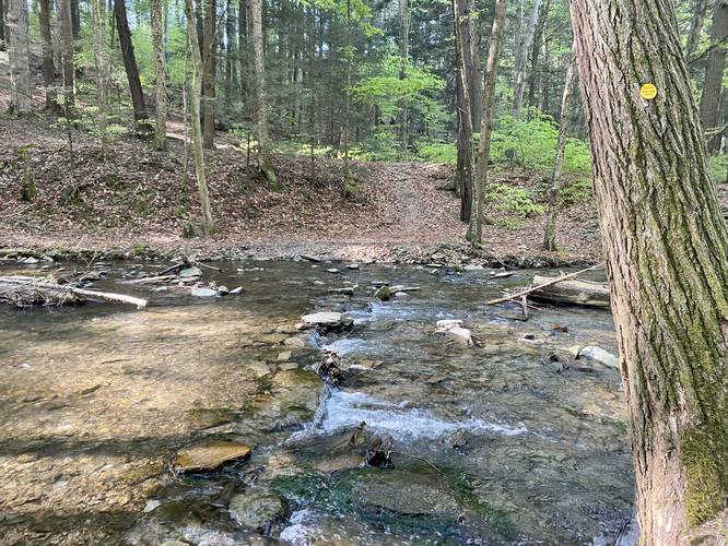
This hike follows one named trail at the park: Yellow Trail (yellow blazes).
Waterfalls
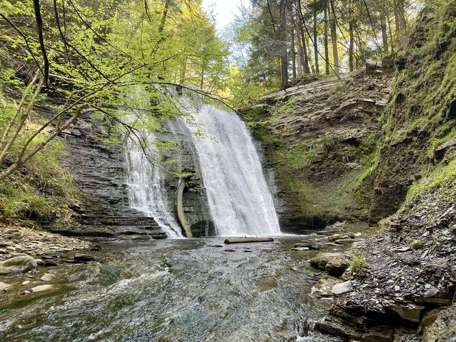
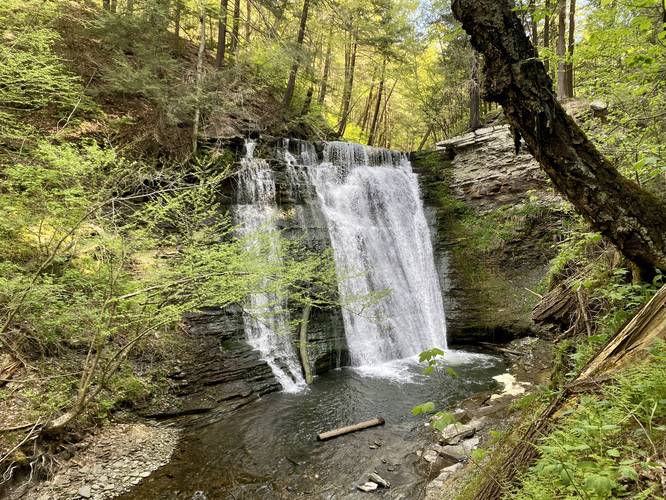
This hike leads to several waterfalls, the largest being ~45-feet tall, named Gully Falls. The other waterfalls are about 2-feet tall, one being about 30-feet wide.
Hike Description
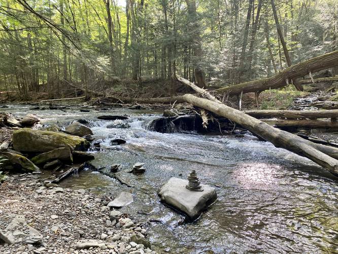
This hike begins on the south side of Whiteman Gully Road and follows the yellow blazed trail as it meanders alongside Little Mill Creek. Along the way, hikers will get to view some smaller waterfalls before the trail crosses Little Mill Creek.
Creek Crossing - Mile 0.1
At mile 0.1, hikers will have to cross the creek in order to view the big 45-foot tall cascade of Gully Falls. Here, you'll likely have to get your feet wet as you cross the stone-filled creek.
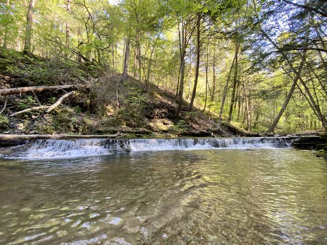
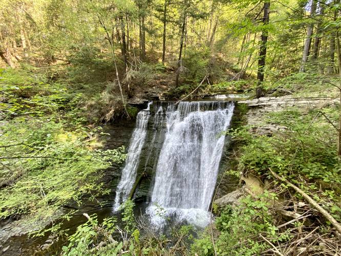
2-foot Tall, 30-foot wide waterfall - Mile 0.13
Around mile 0.13, just after crossing the creek, hikers will reach a very short (2-feet tall) and wide (30-feet) waterfall that cascades down the creek just before the large 45-foot Gully Falls. Note that you'll likely see Gully Falls before you notice this tiny waterfall upstream.
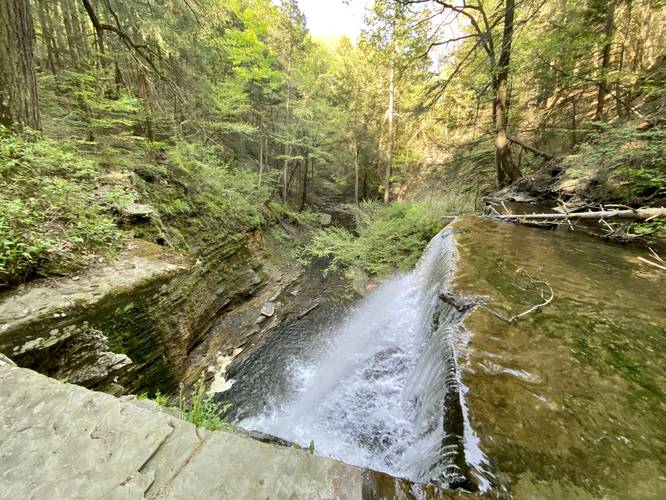
Gully Falls - Mile 0.13
Hikers will also reach the top of Gully Falls around mile 0.13 as well. Watch out, the waterfall cascades over a 45-foot plunge of a cliff. The roar of the waterfall is tempting, but keep back from the cliff's edge for your own safety, as you never know if some of this hillside might buckle under your weight.
Gully Falls Views - Mile 0.15
Just after the very top of Gully Falls, the trail skirts to the side of the cliff to provide additional views of the waterfall.
Sketchy off-trail Gorge Scramble - Mile 0.15+
After mile 0.15, the trail ends. Here I wanted to explore further since the trail appeared to be cleared and beaten down. This was true until the last ~15-vertical feet of reaching the floor of the gorge. This sketchy hillside scramble followed beaten footpath prints down the talus shale hillside to reach the rocky bedrock creek, while being extremely careful (also have had plenty of canyon gorge hillside scrambling experience); however, I would not recommend the general public or folks without this kind of experience to attempt to reach the creek within the gorge as it poses a serious threat to your safety. Note that once you're down off of the shale hillside, the creek bed is all bedrock, so if you fall from above, you won't land on anything soft. Additionally, the walk up the creek is best done in the water as the loose shale rock hillside can easily cause you to slip and potentially get injured. All that said, the views of Gully Falls waterfall from below are pretty nice.
Hiking out is the opposite hike to hiking in - you'll likely get your feet wet on the way out too.
Parking
Hikers will find two very small parking turnouts just west of the trailhead along Whiteman Gully Road. The turnouts are large enough to fit about 3 vehicles each, max.
Pets
Dogs are allowed only if leashed and cleaned up after.
Warning
Steep Cliffs: Note that the largest waterfall cascades off of a large 45-foot tall cliff. These cliffs have the tendency to calve off from time to time, especially under additional weight. It's best to stay further back from the edge for your own safety.
Hillside Scramble: Note that to reach the base of the waterfall, hikers must go off-trail and down a very sketchy and unstable shale talus hillside, which could pose a serious risk.
Creek Crossing: Hikers will have to cross the ~30-foot wide Little Mill Creek to reach Gully Falls, hence you'll end up getting your feet wet.
Trails
This hike follows one named trail at the park: Yellow Trail (yellow blazes).
Waterfalls
This hike leads to several waterfalls, the largest being ~45-feet tall, named Gully Falls. The other waterfalls are about 2-feet tall, one being about 30-feet wide.
Hike Description
This hike begins on the south side of Whiteman Gully Road and follows the yellow blazed trail as it meanders alongside Little Mill Creek. Along the way, hikers will get to view some smaller waterfalls before the trail crosses Little Mill Creek.
Creek Crossing - Mile 0.1
At mile 0.1, hikers will have to cross the creek in order to view the big 45-foot tall cascade of Gully Falls. Here, you'll likely have to get your feet wet as you cross the stone-filled creek.
2-foot Tall, 30-foot wide waterfall - Mile 0.13
Around mile 0.13, just after crossing the creek, hikers will reach a very short (2-feet tall) and wide (30-feet) waterfall that cascades down the creek just before the large 45-foot Gully Falls. Note that you'll likely see Gully Falls before you notice this tiny waterfall upstream.
Gully Falls - Mile 0.13
Hikers will also reach the top of Gully Falls around mile 0.13 as well. Watch out, the waterfall cascades over a 45-foot plunge of a cliff. The roar of the waterfall is tempting, but keep back from the cliff's edge for your own safety, as you never know if some of this hillside might buckle under your weight.
Gully Falls Views - Mile 0.15
Just after the very top of Gully Falls, the trail skirts to the side of the cliff to provide additional views of the waterfall.
Sketchy off-trail Gorge Scramble - Mile 0.15+
After mile 0.15, the trail ends. Here I wanted to explore further since the trail appeared to be cleared and beaten down. This was true until the last ~15-vertical feet of reaching the floor of the gorge. This sketchy hillside scramble followed beaten footpath prints down the talus shale hillside to reach the rocky bedrock creek, while being extremely careful (also have had plenty of canyon gorge hillside scrambling experience); however, I would not recommend the general public or folks without this kind of experience to attempt to reach the creek within the gorge as it poses a serious threat to your safety. Note that once you're down off of the shale hillside, the creek bed is all bedrock, so if you fall from above, you won't land on anything soft. Additionally, the walk up the creek is best done in the water as the loose shale rock hillside can easily cause you to slip and potentially get injured. All that said, the views of Gully Falls waterfall from below are pretty nice.
Hiking out is the opposite hike to hiking in - you'll likely get your feet wet on the way out too.
Parking
Hikers will find two very small parking turnouts just west of the trailhead along Whiteman Gully Road. The turnouts are large enough to fit about 3 vehicles each, max.
Pets
Dogs are allowed only if leashed and cleaned up after.
Warning
Steep Cliffs: Note that the largest waterfall cascades off of a large 45-foot tall cliff. These cliffs have the tendency to calve off from time to time, especially under additional weight. It's best to stay further back from the edge for your own safety.
Hillside Scramble: Note that to reach the base of the waterfall, hikers must go off-trail and down a very sketchy and unstable shale talus hillside, which could pose a serious risk.
Creek Crossing: Hikers will have to cross the ~30-foot wide Little Mill Creek to reach Gully Falls, hence you'll end up getting your feet wet.