Loading...

WINTER SALE! 50% OFF Supporter Accounts — now through January 31st. Learn More.

Gould Trail

The Gould Trail on Mount Greylock, in Adams Massachusetts is a 3.2 mile out-and-back trail that leads up to the summit of Mount Greylock, a backpacking shelter, and two large waterfalls. Mount Greylock is the highest point in Massachusetts at 3,489 feet with an expansive 5-state view at the top and the Gould Trail runs the entire way up. The total length of the Gould Trail is closer to 5 or 6 miles out and back to the summit of Greylock; however, this GPS data only brings you to the shelter and waterfalls about half way up the mountain.

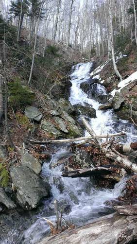
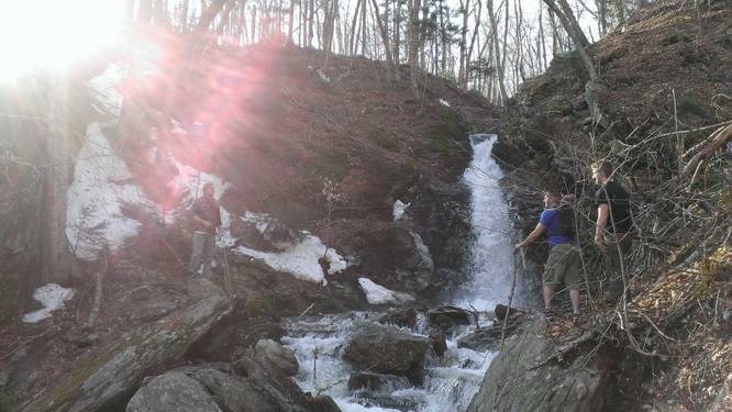
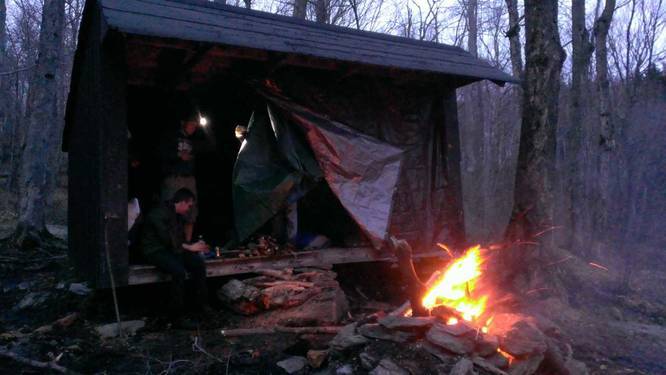
Around mile 1.5 you'll find a left-hand turn which leads to a large backpacking shelter that sits between two large waterfalls. The waterfalls cascade down about 50 to 60 feet to a creek below. One of the cascades sits at ground level with the shelter and the other is slightly taller by about 20 or 30 feet. The waterfalls are best seen in the Spring when the snow is melting off the mountain.

The shelter is about 1.6 miles from the parking lot, hence 3.2 miles total. The top of Mount Greylock is about another 1 or 1.5 miles from the shelter. The round trip to the summit is closer to about 5 or 6 miles.
Explore 17 trails near Adams, MA

Know Before You Go

  • The Gould Trail in Adams, MA, is a 3.2-mile (one-way to the shelter/waterfalls) hike on Mount Greylock.
  • The trail features a backpacking shelter and two waterfalls around the 1.5-mile mark, best viewed in spring.
  • To reach the summit of Mount Greylock with 5-state views, the total round trip hike on the Gould Trail is approximately 5-6 miles.
Interactive topographic map for Gould Trail located in Adams, MA. Click the "View Map" button to load GPS coordinates and trail markers.
Get directions
Distance
3.2 mi
Difficulty
Moderate
Type
Out-and-Back
Est. Time
1.6 hrs
Elev. Gain
1,110'
Rating
0.0
Added
January 23, 2015
Updated
December 13, 2017

Weather Forecast

Loading...
Total Change
1,102'
Ascent
1,110'
Descent
1,110'
Loading...

Download the GPX Data for Offline Use

Supporters get exclusive access to download trail routes to the MyHikes app for offline use. Stay prepared on your adventure, even without an internet connection! Become a Supporter today to unlock this feature and hike with confidence.

Download Gould Trail GPX Data to the MyHikes Mobile App

Features

Vista / Lookout Point
Dogs
Waterfalls
Mountain Summit
Camping
Water Source

Points of interest

  1. Parking

    42.618935, -73.150208
  2. Main Trailhead

    42.61908, -73.150434
  3. Waterfall east of camp

    42.624507, -73.16624
    Waterfall east of camp
  4. Waterfall next to camp

    42.624988, -73.167174
    Waterfall next to camp

Safety information

For your own safety: plan ahead, let someone know where you'll be, and hike at your own risk.

Availability

All seasons

Surface type

Dirt

Trip Reports (Reviews)

Your opinion matters! Be the first to rate this trail.

Ready to help fellow hikers? Add a trip report to share your experience and provide valuable insights for other hikers!

No community routes found. To add your own hike as a Community Route for this Trail guide, leave a Trip Report with an attached GPX file.

Popular categories

Scenic mountain view representing vista trails
Vista trails
Scenic gorge of cascades representing waterfall trails
Waterfall hikes
Rugged mountain terrain representing summit trails
Summit trails
Scenic mountain view representing dog-friendly trails
Dog-friendly
Scenic campsite with a view representing camping trails
Camping trails
Appalachian Trail logo representing A.T. hikes
A.T. hikes

You May Also Like

Colorado's Million Dollar Highway - Plan a day's drive adventure along the iconic Million Dollar Highway in Colorado. Explore the best short trails, roadside stops, waterfalls, vistas, ghost towns, and hot springs within a ~6 hour road trip.
Explore

Colorado's Million Dollar Highway

Plan a day's drive adventure along the iconic Million Dollar Highway in Colorado. Explore the best short trails, roadside stops, waterfalls, vistas, ghost towns, and hot springs within a ~6 hour road trip.

Read
Glacier's Going-to-the-Sun Road - Discover the breathtaking beauty of Glacier National Park along the iconic Going-to-the-Sun Road. From stunning roadside stops to picturesque waterfalls and vistas, this engineering marvel offers endless opportunities for exploration.
Explore

Glacier's Going-to-the-Sun Road

Discover the breathtaking beauty of Glacier National Park along the iconic Going-to-the-Sun Road. From stunning roadside stops to picturesque waterfalls and vistas, this engineering marvel offers endless opportunities for exploration.

Read
🍪 We use cookies to learn about site usage and to serve map tiles. You may block cookies manually in the browser. By continuing you agree. Learn more