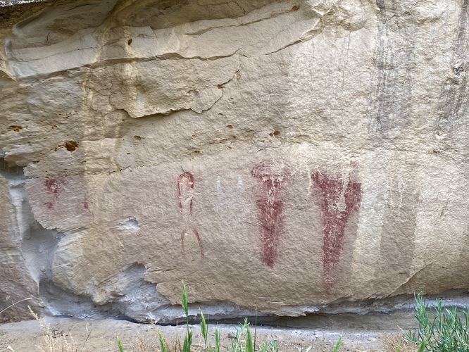
The Fremont Petroglyphs Trail at Canyon Pintado National Historical District near Rangely, Colorado is an easy 0.2-mile out-and-back walk that leads to ancient petroglyphs and pictographs from the ancient Fremont people.
This is not a hike, but rather a very short hike that follows a dirt trail out to view petroglyphs and pictographs. The trail begins on the west side of CO-139 (Dinosaur Diamond Prehistoric Highway) at the coordinates provided -- visitors will notice a barbed-wire fence with a sign for the trailhead. To enter, you must first carefully detach the barbed-wire fence from the post and let it fall to the ground (or hold it open for your group) before immediately reattaching the fence after crossing to the opposite side. By reattaching the fence, you'll ensure any rancher's cattle or grazing animals stay where they need to stay. The trail then leads southward parallel to the road, following the nearby cliff line. Around mile 0.1, you'll find the petroglyphs and pictographs of the ancient Fremont people etched and painted onto the cliff.
The walk back follows the same trail -- just remember to reattach the fence on your way out.
Parking
Visitors will find plenty of parking in a large turnout located at the coordinates provided, on the west side of CO-193 south of Rangely, CO. The lot is large enough to fit a dozen vehicles or so as of June 2024.
Pets
Dogs are allowed only if leashed and must be cleaned up after.
Warning
Ancient petroglyphs: This trail leads to ancient petroglyphs and pictographs that were created hundreds of years ago. Please do not touch or attempt to disturb in any way. Only take photos and appreciate the ancient artwork from behind the barrier.
Barbed-wire fence: To enter this trail, you must move a barbed-wire fence. Be careful. Consider a tetanus shot prior.
Sun exposure: This trail has very little shade and no water sources. Pack-in all water and wear sun screen and a hat to protect against sun exposure. It's smart to hike either in the early morning or late afternoon to avoid the intense sun.
No water: This trail has no water sources so you must pack-in all water. A general rule of thumb in the desert is 1 gallon of water per person per day.
Rattlesnakes: This trail leads through rattlesnake territory, so be on the lookout and give any rattlers you find plenty of space.
Rockfall: This trail passes under a rock cliff that can occasionally have rockfall activity.