The Franklin Falls Trail at Mt. Banker-Snoqualmie National Forest near Snoqualmie Pass, WA is a moderate 2.2-mile out-and-back hike that leads to the 135-foot tall Franklin Falls, Denny Camp Falls, and features views of turquoise waters of the South Fork Snoqualmie River.
Rock fall: The trail follows a very short cliff side path that leads into the gorge near Franklin Falls. Rock fall can happen at any time, is unannounced, and can injure or kill hikers if you're at the wrong place at the wrong time. Keep moving to prevent any rock fall injuries.
Flash flooding: The river can flash flood without warning at any time. Be aware of the weather, especially upstream, when you plan to hike this. If you notice water rising, find higher ground immediately.
Hike to Franklin Falls
This hike begins at the main parking lot where most hikers will begin, thus the route provided follows mile markers from the parking lot trailhead and not the Franklin Falls Trail trailhead. Take the staircase as it leads downhill to cross Denny Creek Road where you'll find the trailhead on the opposite side of the handicapped parking lot. Hop on the trail to follow it north as it leads along the South Fork Snoqualmie River upstream.Private Cabins - Mile 0 to 0.6
After you start up the Franklin Falls Trail, you'll quickly find private cabins located off-trail in the woods which can be found until mile 0.6. These are private cabins, accessed by Denny Camp Road. Please respect the land owners / leasers and do not disturb. Despite not being open to the public, these small forest cabins make for neat photos from the trail, especially if you show up at the right time of day (not mid-day).Turquoise-water Swimming Holes - Mile 0.14 to 0.3
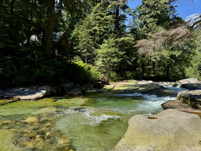
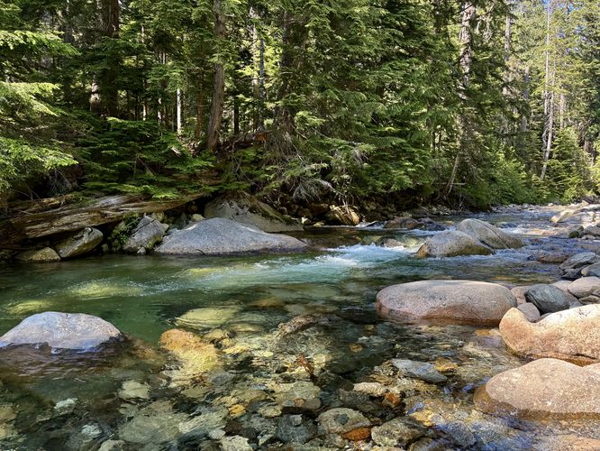
Between miles 0.14 and 0.3 are a couple of off-shoot paths that lead directly to crystal-clear turquoise-hued swimming holes in the South Fork Snoqualmie River. The water might be cold, but there are deep pockets within the river where you can wade up to 4-feet deep to cool off on a hot summer day. If you choose to get into the water, you're swimming at your own risk. Please be aware of possible flash flooding and always pay attention to the weather.Old-growth Tree - Mile 0.35 & 0.46
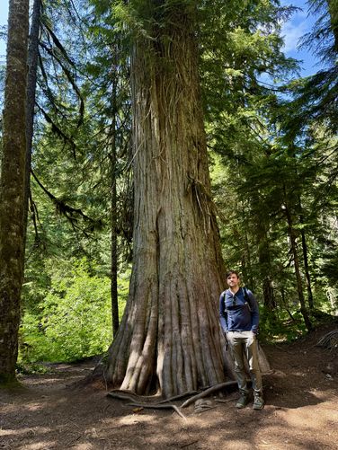
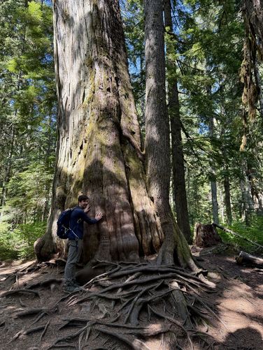
Just past the swimming holes sit two old-growth trees that are noteworthy along the trail. One can be found around mile 0.35 and the other around mile 0.46. Along the way are some top-down views of the river as the trail starts to ascend higher above the water. These views of the river offer glimpses into its crystal-clear waters and multi-colored rocks that line its bed.Denny Camp Falls & Turquoise Pools - Mile 0.5
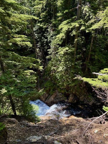
At mile 0.5, hikers will reach the overlook for Denny Camp Falls where you'll find a couple of turquoise pools in the river below your feet with the short but scenic multi-tiered Denny Camp Falls spilling down the bedrock. This downstream overlook provides hikers with the best view of the waterfall, but some fisherman have found a way to reach the pools below. During our hike here, we found someone casting their line into the turquoise-hued pools of Denny Camp Falls, adding to the scenery.Gorge Views & Small Waterfalls - Mile 0.55 to 0.75
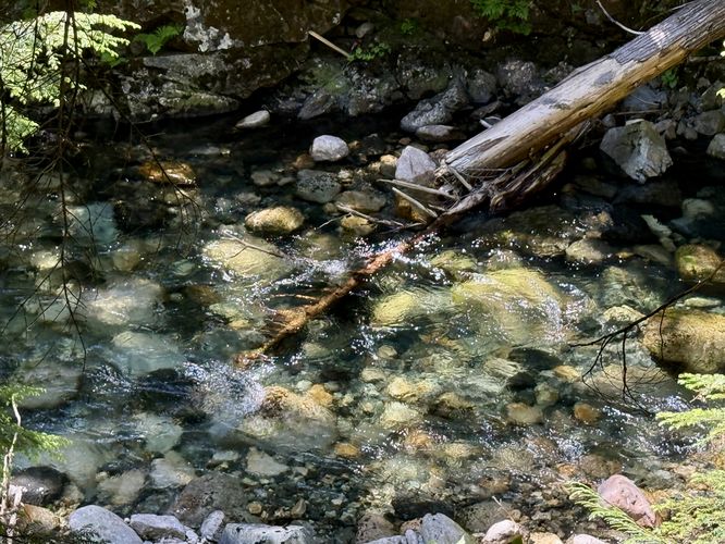
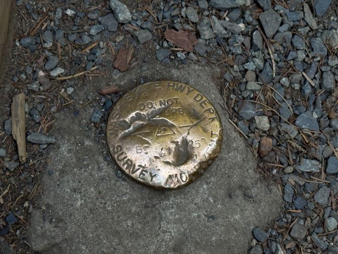
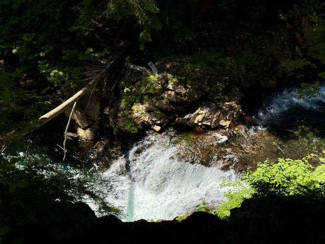
After passing the overlook for Denny Camp Falls, the trail provides more scenery ahead as it ascends the gorge approaching Franklin Falls. Along the way are more views of turquoise-tinted pools, a neat WA state highway survey marker (mile 0.59), and two views of small waterfalls that sit far below your feet. If you plan to take photos of the waterfalls or appreciate them from the edge of the trail, watch your step as the terrain is super steep and dangerous.Franklin Falls View - Mile 1.07
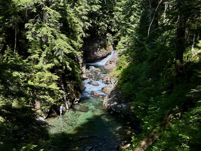
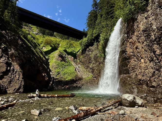
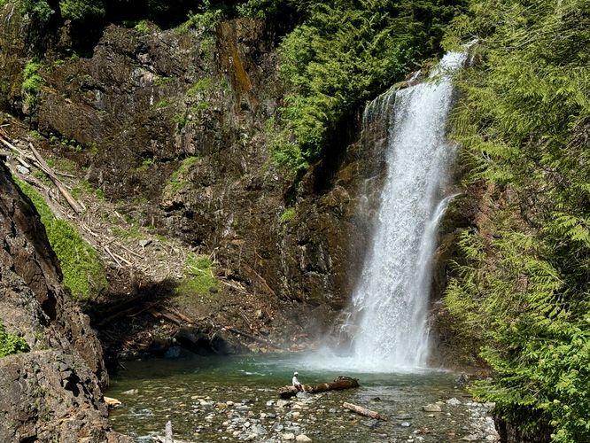
Once you pass the gorge views of small waterfalls, the trail doesn't have too much to offer in terms of views, old-growths, or cascades. You'll pass the Wagon Road Trail at mile 1, just keep straight to reach Franklin Falls. As you approach Franklin Falls, you'll find the trail begins to dip down into the gorge. At mile 1.07, you'll find a beautiful view of the 135-foot tall Franklin Falls from the top of the trail, right after it heads downhill. This is a great spot to take photos or simply enjoy the waterfall from afar. Note that if you plan to reach the base of the waterfall, you'll have to follow along a short but steep cliff to reach it.Base of Franklin Falls (135-feet tall) - Mile 1.1
After hiking down from the viewpoint, hikers will hug the rock wall that traverses into the gorge, following the top of a cliff where the trail becomes fairly skinny. Ensure you are not blocking other hikers before continuing. Once you reach the other side, you'll be at the base of the 135-foot tall Franklin Falls. From its base, you can appreciate the scale and power of this massive waterfall and depending on what time of year you visit will determine its power and flow. In early spring, the waterfall is raging with snow melt, but as the summer draws to an end, it may not be as spectacular as earlier in the year. Regardless of when you visit, the waterfall's impressive height creates a beautiful cloud of mist that fills the gorge and is honestly a great way to cool down. At waterfall's base sits yet another turquoise-tinted pool that seems inviting on a hot day. Enjoy the waterfall and its cloud of mist before you have to hike back.Hiking Out - Mile 1.1 to 2.2
The hike back from Franklin Falls is straight forward. Simply climb out of the gorge by following the cliff path uphill, then follow the trail as it leads mostly all downhill back to the trailhead. Pass the river views, turquoise pools, and swimming holes on your way out or stop to enjoy some of these points-of-interest before the hike is over. Cross Denny Camp Road and return to the parking lot for a 2.2-mile out-and-back hike to Franklin Falls.Parking & Fees
Hikers will find a very large parking lot at the coordinates provided, located off of Denny Camp Road in Snoqualmie Pass, Washington. The lot is large enough to fit a few dozen vehicles as of June 2025. This national forest requires a day use fee which can be paid online using the information kiosks near the trailhead (staircase). You can also leave an Annual National Parks Pass on your dashboard which is accepted instead of a day use fee.Pets
Dogs are allowed only if leashed and must be cleaned up after.Restrooms
This hike has pit toilets near the trailhead at the handicapped parking lot.Warning
Steep terrain: This trail follows areas with views near steep terrain. Watch your step near the edge of cliffs and stay on-trail for your own safety.Rock fall: The trail follows a very short cliff side path that leads into the gorge near Franklin Falls. Rock fall can happen at any time, is unannounced, and can injure or kill hikers if you're at the wrong place at the wrong time. Keep moving to prevent any rock fall injuries.
Flash flooding: The river can flash flood without warning at any time. Be aware of the weather, especially upstream, when you plan to hike this. If you notice water rising, find higher ground immediately.