The Forest Canyon Overlook Trail at Rocky Mountain National Park near Estes Park, Colorado is an easy 0.3-mile out-and-back trail that features breathtaking views of alpine mountains from 11,000-feet.
Walk
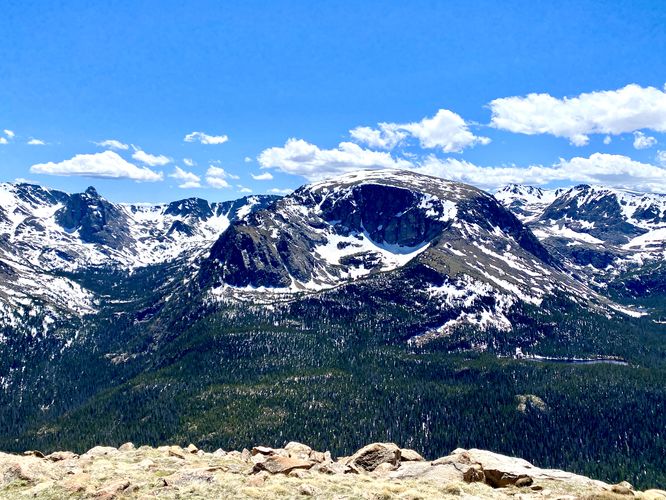
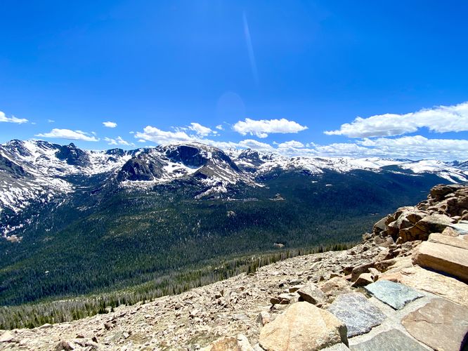
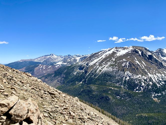
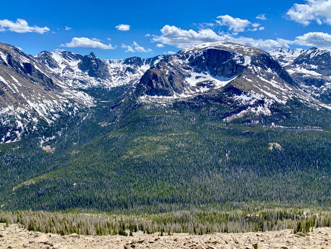
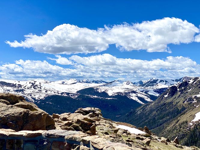
This is not necessarily a hike but rather a short walk that leads through alpine tundra to a panoramic overlook at the end of the trail, high above Forest Canyon. The Forest Canyon Overlook Trail provides views from the trailhead all the way to the end and back to parking, so it's one of the most-popular and heavily-trafficked trails at the park. From the lookout point, you'll see why it's called Forest Canyon -- below, the mountains and valley are lush with evergreen trees that fill the landscape. When snow is still clinging to these mountain's slopes, it creates a dramatic visual difference between the evergreen forest in the canyon below and the snow-capped bright-white mountain peaks above. These snow-laden peaks send water down their slopes to feed and enrich the dense forest below.
Universal Access
This trail is universally accessible and follows a paved pathway out to the overlook. Note that during some seasons, snow may be covering the trail, which can impede its universal accessibility. With that said, the views from the trailhead are almost identical to the views at the end of the trail.
Pets
Dogs are not allowed on this trail.
Parking
Hikers will find a medium-sized parking lot at the coordinates provided, located on Trail Ridge Road. The lot is large enough to fit a couple dozen vehicles as of June 2024.
Wildlife Viewing
This trail can be good to view wildlife like the yellow-bellied marmot as they love the alpine tundra landscape.
Timed-Entry Reservations
Between the months of late May through early October you must purchase a timed-entry pass to visit Rocky Mountain National Park. If you wish to visitor and hike anything off of the Bear Lake Road, you must purchase a dedicated Bear Lake timed-entry pass. You can find more information about timed entry on the park's website.
Warnings
Elevation sickness: This trail brings hikers through terrain that ascends up to 11,600-feet above sea level. Around the 7,000-foot mark above sea level, hikers may start to experience symptoms of elevation sickness including headache, muscle aches, shortness of breath, among other warning signs. In order to avoid elevation sickness it's recommended to ascend to higher elevations and take short walks to acclimate over the course of several days before taking a long or physically-demanding hike. At any time you feel elevation sickness kicking in, that's the time to turn back and head for lower altitude or the parking lot.
Wild animals: While rare, hikers may encounter bears or mountain lion along the trail. Again, this is rare due to the insane amount of people who hike these trails each day; however, it's smart to know that these wild animals could be on-trail. Please read-up on how to properly handle a bear or mountain lion encounter before hitting the trails.
High exposure: This alpine trail is fully exposed with very little, if any shade along the trail. Due to the lack of shade and the combination of altitude at 11,600-feet above sea level, the UV index is significantly higher on this trail than on lower-altitude trails at the park. Sun exposure should be taken seriously and hikers should apply sunscreen or hike when the UV index is not as high. Additionally, due to the lack of trees and shrubs, the trail can be extremely windy. When we did this hike, the wind was almost constant at about 40mph or more, which pushed us around a bit.
Fragile tundra ecosystem: This trail passes through an alpine tundra, which see freezing temperatures 5 months out of the year. Due to the cold weather and harsh wind conditions, tundras see very slow growth and plants can take a very-long time to mature. Additionally, foot steps and trampling can cause plants to take decades to recover. For these reasons, please stay on-trail at all times while hiking in Rocky Mountain's alpine tundra landscapes.
Walk
This is not necessarily a hike but rather a short walk that leads through alpine tundra to a panoramic overlook at the end of the trail, high above Forest Canyon. The Forest Canyon Overlook Trail provides views from the trailhead all the way to the end and back to parking, so it's one of the most-popular and heavily-trafficked trails at the park. From the lookout point, you'll see why it's called Forest Canyon -- below, the mountains and valley are lush with evergreen trees that fill the landscape. When snow is still clinging to these mountain's slopes, it creates a dramatic visual difference between the evergreen forest in the canyon below and the snow-capped bright-white mountain peaks above. These snow-laden peaks send water down their slopes to feed and enrich the dense forest below.
Universal Access
This trail is universally accessible and follows a paved pathway out to the overlook. Note that during some seasons, snow may be covering the trail, which can impede its universal accessibility. With that said, the views from the trailhead are almost identical to the views at the end of the trail.
Pets
Dogs are not allowed on this trail.
Parking
Hikers will find a medium-sized parking lot at the coordinates provided, located on Trail Ridge Road. The lot is large enough to fit a couple dozen vehicles as of June 2024.
Wildlife Viewing
This trail can be good to view wildlife like the yellow-bellied marmot as they love the alpine tundra landscape.
Timed-Entry Reservations
Between the months of late May through early October you must purchase a timed-entry pass to visit Rocky Mountain National Park. If you wish to visitor and hike anything off of the Bear Lake Road, you must purchase a dedicated Bear Lake timed-entry pass. You can find more information about timed entry on the park's website.
Warnings
Elevation sickness: This trail brings hikers through terrain that ascends up to 11,600-feet above sea level. Around the 7,000-foot mark above sea level, hikers may start to experience symptoms of elevation sickness including headache, muscle aches, shortness of breath, among other warning signs. In order to avoid elevation sickness it's recommended to ascend to higher elevations and take short walks to acclimate over the course of several days before taking a long or physically-demanding hike. At any time you feel elevation sickness kicking in, that's the time to turn back and head for lower altitude or the parking lot.
Wild animals: While rare, hikers may encounter bears or mountain lion along the trail. Again, this is rare due to the insane amount of people who hike these trails each day; however, it's smart to know that these wild animals could be on-trail. Please read-up on how to properly handle a bear or mountain lion encounter before hitting the trails.
High exposure: This alpine trail is fully exposed with very little, if any shade along the trail. Due to the lack of shade and the combination of altitude at 11,600-feet above sea level, the UV index is significantly higher on this trail than on lower-altitude trails at the park. Sun exposure should be taken seriously and hikers should apply sunscreen or hike when the UV index is not as high. Additionally, due to the lack of trees and shrubs, the trail can be extremely windy. When we did this hike, the wind was almost constant at about 40mph or more, which pushed us around a bit.
Fragile tundra ecosystem: This trail passes through an alpine tundra, which see freezing temperatures 5 months out of the year. Due to the cold weather and harsh wind conditions, tundras see very slow growth and plants can take a very-long time to mature. Additionally, foot steps and trampling can cause plants to take decades to recover. For these reasons, please stay on-trail at all times while hiking in Rocky Mountain's alpine tundra landscapes.