Loading...

WINTER SALE! 50% OFF Supporter Accounts — now through January 31st. Learn More.

Flume Knob Hike

The Flume Knob Hike at Adirondack Park in Wilmington, New York is a difficult 3.5-mile loop / out-and-back trek that features views of the West Branch Ausable River and leads to the summit of Flume Knob where hikers will find breathtaking views of the Wilmington Valley and surrounding mountains.

Trail names: Corridor Loop Trail, Flume Knob Trail, River Loop Trail

Location: State Route 86, Wilmington Wild Forest, Wilmington NY

Permitted uses: Mountain Biking, Hiking, Cross Country Skiing, Snowshoeing, Catch and release fishing with a license and using ONLY artificial lures, Hunting in season and with a license.

Prohibited uses: No motor vehicles are allowed. No Electric bikes. No camping or overnight parking.

Hours: There are no posted closure hours.

Fees and Parking: There is no fee to park or use the trails. There is a good size parking area that can fit about 14 cars, depending on how well people park, but it fills up quickly. There is a designated area for handicap parking.

Pets: There are no posted restrictions for pets.

Accessibility: These are not wheelchair accessible trails.

Hiker amenities: At the trailhead parking area there is a gender neutral restroom. There isn't any water but there is a trash bin. However, it's very helpful if all visitors would pack out all trash. There is an information Kiosk at the Trailhead with a posted map and regulations for the Preserve. There is a boot washing station for those who fish, and a boot brush for hikers to use before and after hiking. These were installed to try to reduce the unintentional introduction of invasive or harmful species to this area.

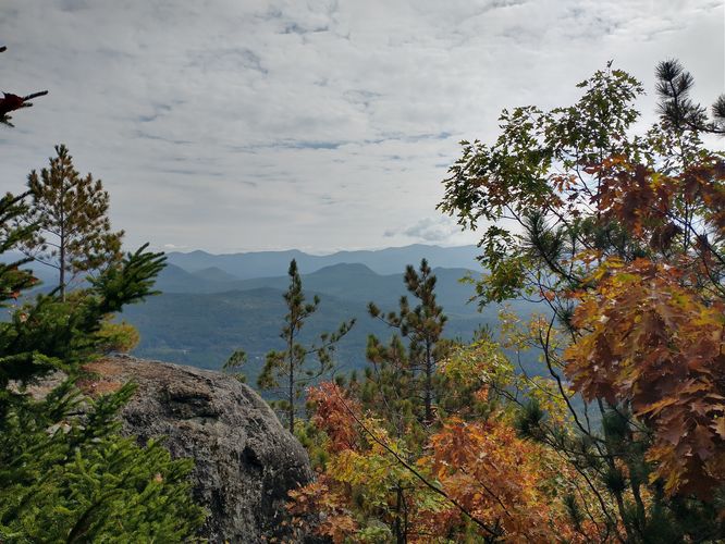
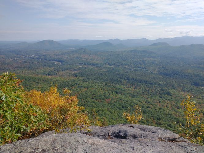
Length and Trail information: This hike was done as an out and back hike with a loop added after completing the Flume Knob trail. The trails have blue trail markers and engraved painted signs at junctions. For the most part, the trails are very well marked, but it’s still a good idea to download a map or take a picture of the one posted at the trailhead Kiosk. The Flume Knob Trail is for foot traffic only and has an ascent of 1,325 feet and it's hard.The Corridor and River Loop Trails are easy. This hike was 3.53 miles in length. Our goal for this hike was to reach the top of the Flume Knob and enjoy the views, we were not disappointed. If you are hoping to see the river and some falls, the best views are found just after the trailhead information Kiosk where there is a small look out area. We enjoyed the wooded serenity of the Corridor Loop Trail and the views along the River Loop trail that offered beautiful views of the Ausable River as well as views of the Flume Knob from below.

The Flume Knob trail is full of challenges. The substrate is tricky due to the expected rocks and roots but during this hike we encountered an unexpected hazard….an overabundance of acorns littering the trail! At times we thought we were hiking on marbles. Acorns can be a real trip/slip/fall hazard and caution should be used, especially during the descent, which at times is very steep. There is a bit of rock scramble and the ascent is steady and steep. There are several places along the trail that are heartbreakers… you think you are reaching the summit, only to find that you have just reached a small plateau and the trail actually continues to ascend. The Flume Knob Trail feels like a solid mile of UP. This trail sees far fewer hikers than other trails, most likely due to the effort needed to reach the summit. We did finally reach the summit of the Flume Knob Trail, and it was worth every bit of effort we put in. The views were amazing and we enjoyed spending some time there before heading back down the trail.

Explore 35 trails near Wilmington, NY

Know Before You Go

  • Flume Knob Hike in Wilmington, NY, is a challenging 3.5-mile loop/out-and-back trail offering scenic views of the Ausable River and Wilmington Valley.
  • The Flume Knob Trail is steep and rocky with an ascent of 1,325 feet, requiring caution due to potential hazards like acorns, while the Corridor and River Loop Trails are easier.
  • The trailhead provides amenities like a restroom, information kiosk, and boot cleaning stations, but parking is limited, and overnight camping/parking, motor vehicles, and electric bikes are prohibited.
Interactive topographic map for Flume Knob Hike located in Wilmington, NY. Click the "View Map" button to load GPS coordinates and trail markers.
Get directions
Distance
3.5 mi
Difficulty
Hard
Type
Loop
Est. Time
1.8 hrs
Elev. Gain
1,342'
Rating
0.0
Added
October 12, 2024
Updated
December 13, 2024

Weather Forecast

Loading...
Total Change
1,263'
Ascent
1,342'
Descent
1,357'
Loading...

Download the GPX Data for Offline Use

Supporters get exclusive access to download trail routes to the MyHikes app for offline use. Stay prepared on your adventure, even without an internet connection! Become a Supporter today to unlock this feature and hike with confidence.

Download Flume Knob Hike GPX Data to the MyHikes Mobile App

Features

Vista / Lookout Point
Dogs
Waterfalls
Mountain Summit
Camping
Water Source
Biking

Points of interest

  1. Parking

    44.3662, -73.841123
  2. Main Trailhead

    44.366107, -73.841498

Safety information

For your own safety: plan ahead, let someone know where you'll be, and hike at your own risk.

Hazards

Poison Ivy or Poison Oak
Rockfalls, Ledges, or Scrambles

Markers

Blaze Color

Blue

Blaze Dot Color

Blue

Availability

All seasons

Surface type

Dirt

Trip Reports (Reviews)

Your opinion matters! Be the first to rate this trail.

Ready to help fellow hikers? Add a trip report to share your experience and provide valuable insights for other hikers!

No community routes found. To add your own hike as a Community Route for this Trail guide, leave a Trip Report with an attached GPX file.

Popular categories

Scenic mountain view representing vista trails
Vista trails
Scenic gorge of cascades representing waterfall trails
Waterfall hikes
Rugged mountain terrain representing summit trails
Summit trails
Scenic mountain view representing dog-friendly trails
Dog-friendly
Scenic campsite with a view representing camping trails
Camping trails
Appalachian Trail logo representing A.T. hikes
A.T. hikes

You May Also Like

Colorado's Million Dollar Highway - Plan a day's drive adventure along the iconic Million Dollar Highway in Colorado. Explore the best short trails, roadside stops, waterfalls, vistas, ghost towns, and hot springs within a ~6 hour road trip.
Explore

Colorado's Million Dollar Highway

Plan a day's drive adventure along the iconic Million Dollar Highway in Colorado. Explore the best short trails, roadside stops, waterfalls, vistas, ghost towns, and hot springs within a ~6 hour road trip.

Read
Glacier's Going-to-the-Sun Road - Discover the breathtaking beauty of Glacier National Park along the iconic Going-to-the-Sun Road. From stunning roadside stops to picturesque waterfalls and vistas, this engineering marvel offers endless opportunities for exploration.
Explore

Glacier's Going-to-the-Sun Road

Discover the breathtaking beauty of Glacier National Park along the iconic Going-to-the-Sun Road. From stunning roadside stops to picturesque waterfalls and vistas, this engineering marvel offers endless opportunities for exploration.

Read
🍪 We use cookies to learn about site usage and to serve map tiles. You may block cookies manually in the browser. By continuing you agree. Learn more