The Fall Creek Gorge Loop in Ithaca, New York is a moderate 1.6-mile loop hike that features views of some of Ithaca's largest waterfalls including Triphammer Falls, Rocky Falls, Horseshoe Falls, and Forest Falls.
Park
This trail and natural area are managed by the Cornell Botanic Gardens.
Trails
This hike follows three named trails: Fall Creek Gorge Loop (faded orange blazes), Risley Trail (red blazes), Horseshoe Falls Trail (red blazes).
Hike Description
This hike begins at the large parking lot (coordinates provided) located along Forest Home Drive and follows the paved path as it heads in toward Triphammer Falls. Hikers will begin by heading downhill from the parking lot following the path as it curves and heads over the footbridge.
Triphammer Falls (80-feet tall) - Mile 0.1
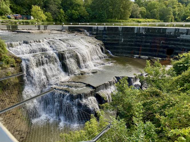
Around mile 0.1, hikers will get views of the 80-foot tall Triphammer Falls as it cascades down the creek's bedrock below your feet as your cross the footbridge. Hikers will also get views looking downstream of Fall Creek where they'll find the Thurston Ave bridge spanning the gorge.
The trail will then meander around the buildings, crossing Thurston Ave, before it heads down into the gorge
Risley Trail to Fall Creek - Mile 0.3 to 0.5
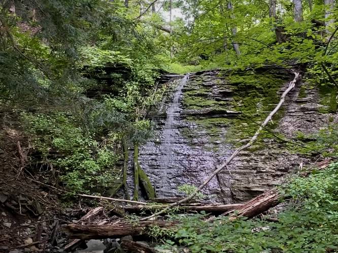
Around mile 0.3, hikers will reach the Risley Trail which heads down into the gorge to a picnic area. Hikers will find two waterfalls down along the Risley Trail - one waterfall sits within Fall Creek - about 3-feet tall and about as wide as the creek itself. In the woods along the gorge walls is a small tributary creek that flows down where hikers will find a ~10-foot tall seasonal waterfall as well. For simplicity, hikers can refer to this as Risley Falls.
After exploring the Risley Trail and Fall Creek from up-close, hikers will follow the trail as it heads past the tennis courts to walk along Fall Creek Drive. Hikers will follow the road until they reach the suspension bridge.
Suspension Bridge / Rocky Falls View - Mile 0.73 to 0.8
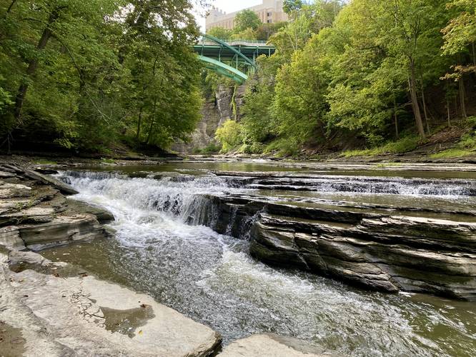
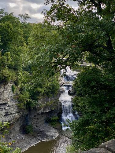
Around mile 0.73, hikers will reach a suspension bridge that crosses Fall Creek Gorge. From the suspension bridge, hikers will get the only view of the 55-foot tall Rocky Falls that cascades down the gorge adjacent to the hydroelectric plant. After the suspension bridge, hikers will want to check out Horseshoe Falls - take a right-hand turn to head downhill toward the Horseshoe Falls Trail.
Horseshoe Falls (30-feet tall) - Mile 1
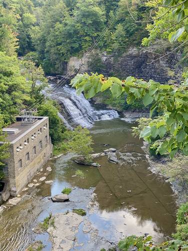
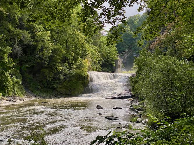
Hikers will reach an off-shoot trail that leads down the gorge around mile 0.93 - this is the Horseshoe Falls Trail. Hike down along this trail's series of stone steps to reach Fall Creek once more where you'll find stunning views of the 30-foot tall Horseshoe Falls just upstream. Below your feet is a nice short waterfall as well. Note that swimming is strictly prohibited due to previous drowning incidents, so stay on-trail at all times. Note that hikers can see the top of Forest Falls (60-feet tall) from the Horseshoe Falls Trail, but you cannot actually see the cascading water unfortunately. If you want to enjoy Forest Falls, head to the Stewart Ave bridge.
Connecting the Loop - Mile 1 to 1.6
After taking in the views of Horseshoe Falls, hikers will hike up the stairs of the Horseshoe Falls Trail, then back up a series of stairs to reach University Ave. Once on University Ave, hike down the road - crossing Thurston Ave once more - before reaching the parking lot. Between Thurston Ave and the parking lot is a nice view, between the safety fence, of Triphammer Falls' entirety, which is worth a look.
Parking
Hikers will find a large parking lot at the coordinates provided. The lot is large enough to fit a few dozen vehicles.
Pets
Dogs are allowed only if leashed and must be cleaned up after.
Warning
No swimming: Due to previous drowning incidents in Fall Creek Gorge, swimming is strictly prohibited for your own safety. Do not swim here.
Park
This trail and natural area are managed by the Cornell Botanic Gardens.
Trails
This hike follows three named trails: Fall Creek Gorge Loop (faded orange blazes), Risley Trail (red blazes), Horseshoe Falls Trail (red blazes).
Hike Description
This hike begins at the large parking lot (coordinates provided) located along Forest Home Drive and follows the paved path as it heads in toward Triphammer Falls. Hikers will begin by heading downhill from the parking lot following the path as it curves and heads over the footbridge.
Triphammer Falls (80-feet tall) - Mile 0.1
Around mile 0.1, hikers will get views of the 80-foot tall Triphammer Falls as it cascades down the creek's bedrock below your feet as your cross the footbridge. Hikers will also get views looking downstream of Fall Creek where they'll find the Thurston Ave bridge spanning the gorge.
The trail will then meander around the buildings, crossing Thurston Ave, before it heads down into the gorge
Risley Trail to Fall Creek - Mile 0.3 to 0.5
Around mile 0.3, hikers will reach the Risley Trail which heads down into the gorge to a picnic area. Hikers will find two waterfalls down along the Risley Trail - one waterfall sits within Fall Creek - about 3-feet tall and about as wide as the creek itself. In the woods along the gorge walls is a small tributary creek that flows down where hikers will find a ~10-foot tall seasonal waterfall as well. For simplicity, hikers can refer to this as Risley Falls.
After exploring the Risley Trail and Fall Creek from up-close, hikers will follow the trail as it heads past the tennis courts to walk along Fall Creek Drive. Hikers will follow the road until they reach the suspension bridge.
Suspension Bridge / Rocky Falls View - Mile 0.73 to 0.8
Around mile 0.73, hikers will reach a suspension bridge that crosses Fall Creek Gorge. From the suspension bridge, hikers will get the only view of the 55-foot tall Rocky Falls that cascades down the gorge adjacent to the hydroelectric plant. After the suspension bridge, hikers will want to check out Horseshoe Falls - take a right-hand turn to head downhill toward the Horseshoe Falls Trail.
Horseshoe Falls (30-feet tall) - Mile 1
Hikers will reach an off-shoot trail that leads down the gorge around mile 0.93 - this is the Horseshoe Falls Trail. Hike down along this trail's series of stone steps to reach Fall Creek once more where you'll find stunning views of the 30-foot tall Horseshoe Falls just upstream. Below your feet is a nice short waterfall as well. Note that swimming is strictly prohibited due to previous drowning incidents, so stay on-trail at all times. Note that hikers can see the top of Forest Falls (60-feet tall) from the Horseshoe Falls Trail, but you cannot actually see the cascading water unfortunately. If you want to enjoy Forest Falls, head to the Stewart Ave bridge.
Connecting the Loop - Mile 1 to 1.6
After taking in the views of Horseshoe Falls, hikers will hike up the stairs of the Horseshoe Falls Trail, then back up a series of stairs to reach University Ave. Once on University Ave, hike down the road - crossing Thurston Ave once more - before reaching the parking lot. Between Thurston Ave and the parking lot is a nice view, between the safety fence, of Triphammer Falls' entirety, which is worth a look.
Parking
Hikers will find a large parking lot at the coordinates provided. The lot is large enough to fit a few dozen vehicles.
Pets
Dogs are allowed only if leashed and must be cleaned up after.
Warning
No swimming: Due to previous drowning incidents in Fall Creek Gorge, swimming is strictly prohibited for your own safety. Do not swim here.