The hike to Eternal Flame Falls via Eternal Flame Trail at Chestnut Ridge Park near Orchard Park, New York is a moderate 1.2-mile out-and-back hike to a 25-foot waterfall that features a natural gas-fueled "eternal flame" that sits behind the cascading water.
Trails
This hike follows one named trail: Eternal Flame Trail, marked with flame symbols on the trees.
Hike Description
This hike begins at the main trailhead located on the southwest corner of the massive parking. The trail heads into the woods along a well-beaten path, following flame markers as it undulates its way toward the gorge. The trail will run adjacent to the gorge where you can hear the waterfall cascading below your feet -- it's best to stay on-trail here to avoid the extremely-steep gorge drop-offs above Eternal Flame Falls.
Stairs into the Gorge - Mile 0.3 to 0.4
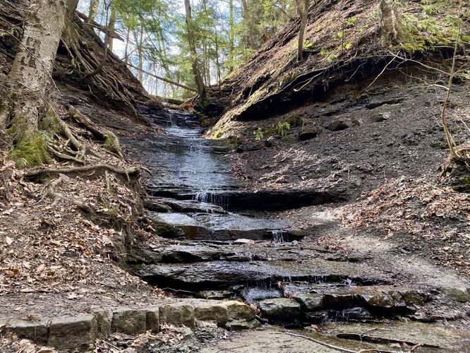
The trail will reach a series of stairs before taking a left-hand turn down another staircase that leads further into the gorge. Once in the gorge, hikers will have to walk up the creek bed to reach Eternal Flame Falls. The creek, during our hike in early March 2024, was not deep (at most 3-inches deep on average); however, depending on recent rainfall or snow melt the creek may be impassible during certain times of the year.
Tributary Waterfalls - Mile 0.5
On your way up the gorge, you'll also find a tributary waterfall that cascades in from the south rim. This waterfall has far less water than Eternal Flame Falls, but is still a nice stop along the hike, located around mile 0.5.
Eternal Flame Falls - Mile 0.6
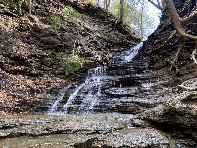
Hikers will reach Eternal Flame Falls around mile 0.6 after making their way up the entire gorge's creek bed. Eternal Flame Falls cascades down the bedrock in a two-tier waterfall, approximately 25-feet tall in total. Behind the lowest tier is a notch in the bedrock where the eternal flame flickers and dances behind the waterfall, assuming it's still lit. The flame appears to grow to about 8-inches in maximum height and sometimes has to be re-lit. The surrounding area near the waterfall does not provide a ton of room to hang out, especially during busy weekends, so take your photos and memories before making room for the next group of hikers.
The hike out from Eternal Flame Falls, following this route, simply heads back the same way you hiked-in. The creek's often-slipper bedrock and the stairs out of the gorge are the only obstacles. The hike should not be difficult for most people, hence the moderate difficulty.
Popularity
This is a very popular hike near Buffalo, NY. Expect to see people here even during weekdays.
Parking
Hikers will find a massive parking lot near the parking coordinates provided, located on the west side of Chestnut Ridge Road. The lot is large enough to fit many dozens of vehicles.
Pets
Dogs are allowed only if leashed and must be cleaned up after.
Warnings
Steep gorge: This hike follows the top of a very steep gorge. It's best to remain on-trail and away from the gorge's edge. The best view of the waterfall is from its base, not above.
Slippery creek: This hike follows a creek bed with several slick and slippery sections. It's best to bring proper footwear and hike it slow to avoid injury.
Trails
This hike follows one named trail: Eternal Flame Trail, marked with flame symbols on the trees.
Hike Description
This hike begins at the main trailhead located on the southwest corner of the massive parking. The trail heads into the woods along a well-beaten path, following flame markers as it undulates its way toward the gorge. The trail will run adjacent to the gorge where you can hear the waterfall cascading below your feet -- it's best to stay on-trail here to avoid the extremely-steep gorge drop-offs above Eternal Flame Falls.
Stairs into the Gorge - Mile 0.3 to 0.4
The trail will reach a series of stairs before taking a left-hand turn down another staircase that leads further into the gorge. Once in the gorge, hikers will have to walk up the creek bed to reach Eternal Flame Falls. The creek, during our hike in early March 2024, was not deep (at most 3-inches deep on average); however, depending on recent rainfall or snow melt the creek may be impassible during certain times of the year.
Tributary Waterfalls - Mile 0.5
On your way up the gorge, you'll also find a tributary waterfall that cascades in from the south rim. This waterfall has far less water than Eternal Flame Falls, but is still a nice stop along the hike, located around mile 0.5.
Eternal Flame Falls - Mile 0.6
Hikers will reach Eternal Flame Falls around mile 0.6 after making their way up the entire gorge's creek bed. Eternal Flame Falls cascades down the bedrock in a two-tier waterfall, approximately 25-feet tall in total. Behind the lowest tier is a notch in the bedrock where the eternal flame flickers and dances behind the waterfall, assuming it's still lit. The flame appears to grow to about 8-inches in maximum height and sometimes has to be re-lit. The surrounding area near the waterfall does not provide a ton of room to hang out, especially during busy weekends, so take your photos and memories before making room for the next group of hikers.
The hike out from Eternal Flame Falls, following this route, simply heads back the same way you hiked-in. The creek's often-slipper bedrock and the stairs out of the gorge are the only obstacles. The hike should not be difficult for most people, hence the moderate difficulty.
Popularity
This is a very popular hike near Buffalo, NY. Expect to see people here even during weekdays.
Parking
Hikers will find a massive parking lot near the parking coordinates provided, located on the west side of Chestnut Ridge Road. The lot is large enough to fit many dozens of vehicles.
Pets
Dogs are allowed only if leashed and must be cleaned up after.
Warnings
Steep gorge: This hike follows the top of a very steep gorge. It's best to remain on-trail and away from the gorge's edge. The best view of the waterfall is from its base, not above.
Slippery creek: This hike follows a creek bed with several slick and slippery sections. It's best to bring proper footwear and hike it slow to avoid injury.