The Elk Mountain Loop at Elk Mountain Ski Resort in Union Dale, Pennsylvania is a strenuous 2.1-mile loop hike that features a summit of the North Knob on Elk Mountain.
Spring - Fall Hiking Only
Note that Elk Mountain Ski Resort owns North Knob on Elk Hill / Elk Mountain; however, when the ski season is over, they allow hikers and mountain bikers to explore their trails for free. As of Winter 2023, I checked with Elk Mountain Ski Resort and they confirmed this; however, things change, so it's best to double-check before planning your hike.
Trails
This hike follows the following ski trail routes in order: E/F Chair Lift, Lakawanna Spur (black diamond), off-trail summit hike, Tioga Spur, E/F Chair Lift.
Hike Description
Hikers will begin at the main parking lot and walk down toward the closed gate that leads into the ski resort. Before the closed gate, there's a "trailhead" for the E/F Ski Lift - the hike begins here. Hikers will follow the ski lift as it ascends Elk Mountain at a moderate grade.
Lakawanna Spur - Mile 0.3
Around mile 0.3 the hike will become tougher - this route brings hikers south crossing the Tioga Spur and Hiawatha to reach the Lakawanna Spur.
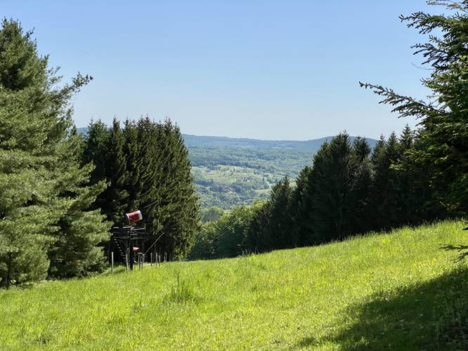
Lakawanna Spur / Black Diamond - Mile 0.5
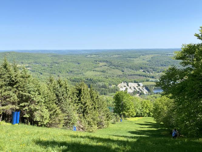
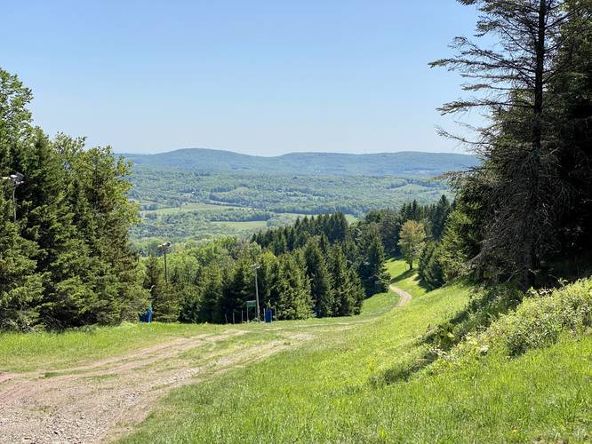
At mile 0.5, the Lakawanna Spur becomes a black diamond route and the hiking becomes even harder; however, by now the hiker has already gained enough elevation to get a couple of views on the way up. By the time you reach this junction, the views just get better and better as you slowly ascent the mountain.
Mountain Top - Mile 0.8
Around mile 0.8, the hardest elevation grade is finally over and the hiker is essentially at the top of Elk Mountain's / Elk Hill's North Knob.
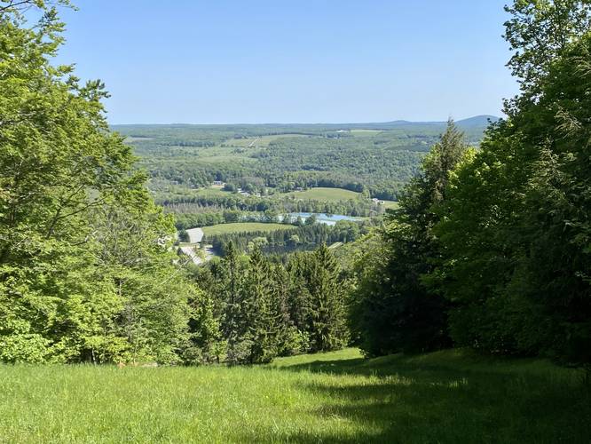
Views - Mile 0.8 to 0.85
From mile 0.8 to 0.85 hikers will head southwest along the 'top' of the mountain with views from the Lakawanna Spur and Susquehanna Trail (black diamond).
North Knob / Elk Mountain Summit - Mile 0.95
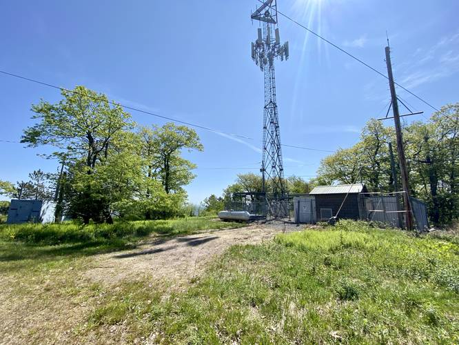
Most people will skip this, but if you wish to truly summit the mountain, you can reach the top around mile 0.95 where radio towers and other maintenance buildings sit. It's an uninviting place, but I came up here in search of old USGS survey or summit markers. Unfortunately I didn't find any; however, online databases seem to indicate there might still be at least one lingering at the top somewhere.
Tunkhannock Vista - Mile 1.15
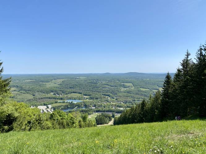
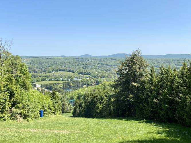
Around mile 1.15, or sooner if you skip the true mountain summit, hikers will reach the black diamond Tunkhannock Trail Vista, which is the last big view you'll get before you hike down Elk Mountain.
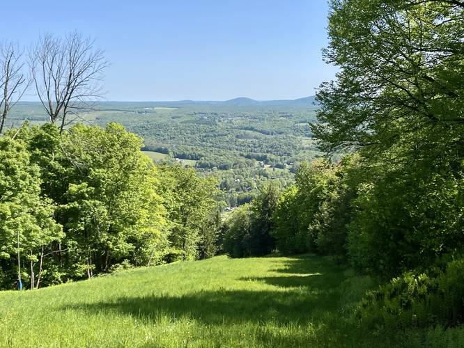
Tioga Spur to Chair Lift - Mile 1.15 to 1.8
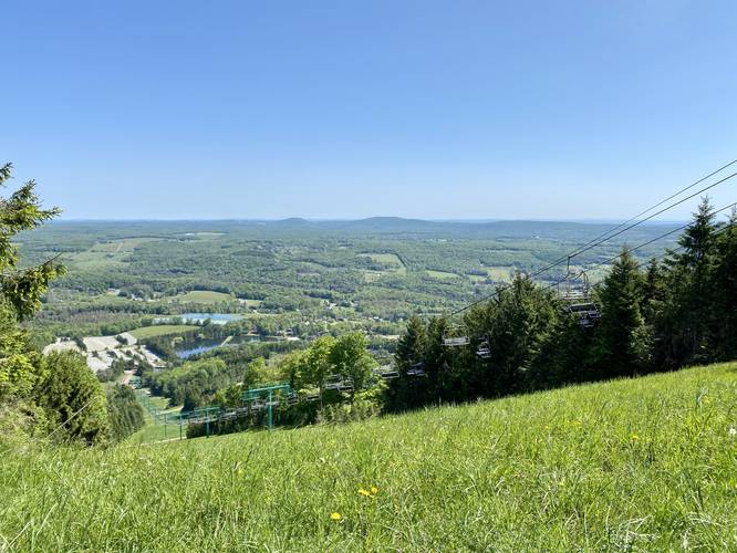
From mile 1.15 to 1.8 hikers will follow the moderate grade of the Tioga Spur as it winds its way down the northern slopes of Elk Mountain. Hikers will get views along the way down as well, but they dwindle more and more as you lose elevation, enjoy them while they last! Note that as of May 2023, parts of the Tioga Spur had hidden holes in the grass which caused a sprained ankle on this hike.
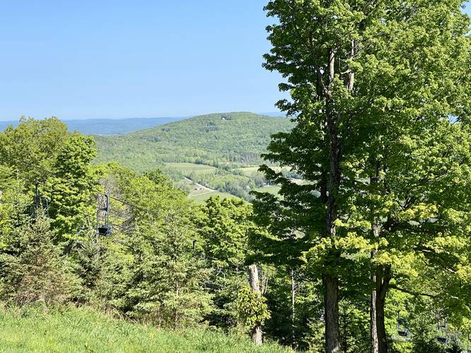
Chair Lift to Parking - Mile 1.8 to 2.1
From mile 1.8 to 2.1, hikers will follow the trail that runs under the chair lift to reach the main parking lot.
Parking
Hikers will find a massive parking lot at the coordinates provided.
Pets
Dogs are allowed if leashed and must be cleaned up after.
Warnings
Sun Exposure: There's very little shade along this hike unless you show up in the earlier morning or catch the sun at a good position as these ski runs are very wide. Most of the shade can be found on the side of the trails, but avoiding mid-day sun is best.
Lack of Water: In addition to sun exposure, this trail has no water sources for the public to use. Pack in all of the water you think you'll need and then double it due to the intense elevation gain along this route.
Uneven Ground: The Tioga Spur, for example, had some uneven ground that caused a hiker on our trip to sprain an ankle. These small holes and uneven surfaces are hidden by the overgrown grass on these ski runs. It's best to hike slowly down the mountain, as you do up, to reduce risk of rolling and spraining an ankle.
Spring - Fall Hiking Only
Note that Elk Mountain Ski Resort owns North Knob on Elk Hill / Elk Mountain; however, when the ski season is over, they allow hikers and mountain bikers to explore their trails for free. As of Winter 2023, I checked with Elk Mountain Ski Resort and they confirmed this; however, things change, so it's best to double-check before planning your hike.
Trails
This hike follows the following ski trail routes in order: E/F Chair Lift, Lakawanna Spur (black diamond), off-trail summit hike, Tioga Spur, E/F Chair Lift.
Hike Description
Hikers will begin at the main parking lot and walk down toward the closed gate that leads into the ski resort. Before the closed gate, there's a "trailhead" for the E/F Ski Lift - the hike begins here. Hikers will follow the ski lift as it ascends Elk Mountain at a moderate grade.
Lakawanna Spur - Mile 0.3
Around mile 0.3 the hike will become tougher - this route brings hikers south crossing the Tioga Spur and Hiawatha to reach the Lakawanna Spur.
Lakawanna Spur / Black Diamond - Mile 0.5
At mile 0.5, the Lakawanna Spur becomes a black diamond route and the hiking becomes even harder; however, by now the hiker has already gained enough elevation to get a couple of views on the way up. By the time you reach this junction, the views just get better and better as you slowly ascent the mountain.
Mountain Top - Mile 0.8
Around mile 0.8, the hardest elevation grade is finally over and the hiker is essentially at the top of Elk Mountain's / Elk Hill's North Knob.
Views - Mile 0.8 to 0.85
From mile 0.8 to 0.85 hikers will head southwest along the 'top' of the mountain with views from the Lakawanna Spur and Susquehanna Trail (black diamond).
North Knob / Elk Mountain Summit - Mile 0.95
Most people will skip this, but if you wish to truly summit the mountain, you can reach the top around mile 0.95 where radio towers and other maintenance buildings sit. It's an uninviting place, but I came up here in search of old USGS survey or summit markers. Unfortunately I didn't find any; however, online databases seem to indicate there might still be at least one lingering at the top somewhere.
Tunkhannock Vista - Mile 1.15
Around mile 1.15, or sooner if you skip the true mountain summit, hikers will reach the black diamond Tunkhannock Trail Vista, which is the last big view you'll get before you hike down Elk Mountain.
Tioga Spur to Chair Lift - Mile 1.15 to 1.8
From mile 1.15 to 1.8 hikers will follow the moderate grade of the Tioga Spur as it winds its way down the northern slopes of Elk Mountain. Hikers will get views along the way down as well, but they dwindle more and more as you lose elevation, enjoy them while they last! Note that as of May 2023, parts of the Tioga Spur had hidden holes in the grass which caused a sprained ankle on this hike.
Chair Lift to Parking - Mile 1.8 to 2.1
From mile 1.8 to 2.1, hikers will follow the trail that runs under the chair lift to reach the main parking lot.
Parking
Hikers will find a massive parking lot at the coordinates provided.
Pets
Dogs are allowed if leashed and must be cleaned up after.
Warnings
Sun Exposure: There's very little shade along this hike unless you show up in the earlier morning or catch the sun at a good position as these ski runs are very wide. Most of the shade can be found on the side of the trails, but avoiding mid-day sun is best.
Lack of Water: In addition to sun exposure, this trail has no water sources for the public to use. Pack in all of the water you think you'll need and then double it due to the intense elevation gain along this route.
Uneven Ground: The Tioga Spur, for example, had some uneven ground that caused a hiker on our trip to sprain an ankle. These small holes and uneven surfaces are hidden by the overgrown grass on these ski runs. It's best to hike slowly down the mountain, as you do up, to reduce risk of rolling and spraining an ankle.