The Crawford Path Trail is a strenuous 9 mile out-and-back hike that leads through the southern section of the Presidential Range of the White Mountain National Forest in New Hampshire. This section covers Mount Pierce and ends at the summit of Mount Eisenhower before heading back. You'll technically follow the Crawford Path Trail to Mount Pierce and then hike the Appalachian Trail along the ridge of the Presidential Range to Mount Eisenhower.
The entire trail has a steep grade with large rocks, which makes hiking up especially difficult because you're essentially hiking up stairs of different heights. Hiking poles on this trail are recommended to help spread the load from your knees onto your upper body.
The majority of this hike is fairly boring as you climb Mount Pierce through thick forests before reaching the treeline. The treeline ends right around the summit of Mount Pierce, so don't plan on getting any views until you reach the first summit. From there, the views are well worth the effort.
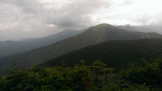
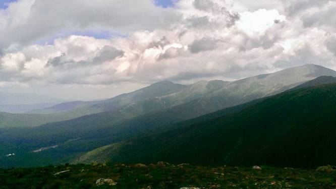
Views: At the top of Mount Pierce, you'll get amazing views of Mount Eisenhower and Mt Washington behind it. Continuing on from Mount Pierce, follow the Appalachian Trail north. The trail flattens out and runs along low-growth brush before heading uphill to the summit of Mount Eisenhower. From the summit of Mt Eisenhower, you'll get even better views looking back to Mount Pierce, over to Mount Washington, down to the valleys below, and beyond.
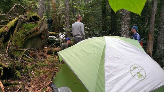
Camping: There are sparse camping opportunities, but great views of Mount Washington and the surrounding area, so this is a very popular day hike. If you plan to camp, you may want to consider hammock camping and looking for sparse areas between the trees since the entire trail lies on a steep grade. You can find small patches of flat ground, but they're rare - see the trail map camping marker for an idea of where we camped. You are also not permitted to camp above the tree line since the temperatures and winds can be dangerous.
Parking: Parking can be found just after turning onto Mt Clinton Rd from Route 302. There's a parking lot with a pay station. In 2014 the cost was about $5 - 7 per night to park there, but that may have changed since.
Trailhead: The trailhead can be found at the north side of the parking lot. Follow it for about 0.3 miles before you cross Gibbs Brook. After crossing Gibbs Brook, the trail shoots straight up Mount Pierce.
The entire trail has a steep grade with large rocks, which makes hiking up especially difficult because you're essentially hiking up stairs of different heights. Hiking poles on this trail are recommended to help spread the load from your knees onto your upper body.
The majority of this hike is fairly boring as you climb Mount Pierce through thick forests before reaching the treeline. The treeline ends right around the summit of Mount Pierce, so don't plan on getting any views until you reach the first summit. From there, the views are well worth the effort.
Views: At the top of Mount Pierce, you'll get amazing views of Mount Eisenhower and Mt Washington behind it. Continuing on from Mount Pierce, follow the Appalachian Trail north. The trail flattens out and runs along low-growth brush before heading uphill to the summit of Mount Eisenhower. From the summit of Mt Eisenhower, you'll get even better views looking back to Mount Pierce, over to Mount Washington, down to the valleys below, and beyond.
Camping: There are sparse camping opportunities, but great views of Mount Washington and the surrounding area, so this is a very popular day hike. If you plan to camp, you may want to consider hammock camping and looking for sparse areas between the trees since the entire trail lies on a steep grade. You can find small patches of flat ground, but they're rare - see the trail map camping marker for an idea of where we camped. You are also not permitted to camp above the tree line since the temperatures and winds can be dangerous.
Parking: Parking can be found just after turning onto Mt Clinton Rd from Route 302. There's a parking lot with a pay station. In 2014 the cost was about $5 - 7 per night to park there, but that may have changed since.
Trailhead: The trailhead can be found at the north side of the parking lot. Follow it for about 0.3 miles before you cross Gibbs Brook. After crossing Gibbs Brook, the trail shoots straight up Mount Pierce.