Corbett's Glen Hike & Waterfalls at Corbett's Glen Nature Park in Brighton, New York is an easy 2.2-mile loop hike that features two beautiful waterfalls.
Trails This hike follows several named trails in the following order: Stone Dust Loop, Woodchip Loop, Long Woodchip Loop, Perimeter Trail. On the hike out from the Perimeter Trail hikers will follow the Long Woodchip Trail and the western side of the Woodchip Loop and Stone Dust Loop to reach parking.
Hike Description
This hike begins at the northern (main) parking lot for Corbett's Glen Nature Park and follows the Stone Dust Loop in. On the way to the waterfalls, this hike follows the northern-most part of each loop before reaching the Long Woodchip Trail. For the most part, the trails don't have too much to see along the way; however, as of May 2023 at mile 0.1 was a large teepee-like structure made of large pine branches.
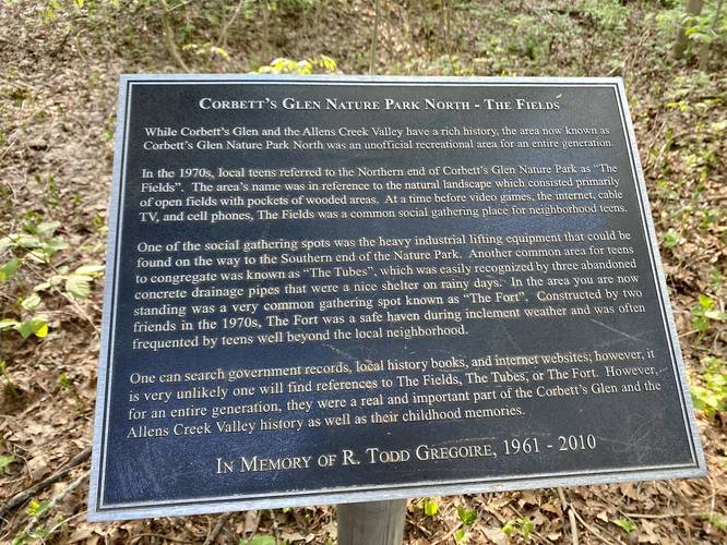
Historical Plaque - Mile 0.3
At mile 0.3 is an informational plaque about the history of the land and how it got its name.
Long Woodchip Trail - Mile 0.45
At mile 0.45, hikers will reach the Long Woodchip Trail which is an out-and-back trail that connects both loops in the park.
Ravine Hill - Mile 0.6
Around mile 0.6 is a dip in the trail that leads into a ravine - this is noted simply for the steeper elevation change and likely the "hardest" section on the trail.
Perimeter Trail Junction - Mile 0.7
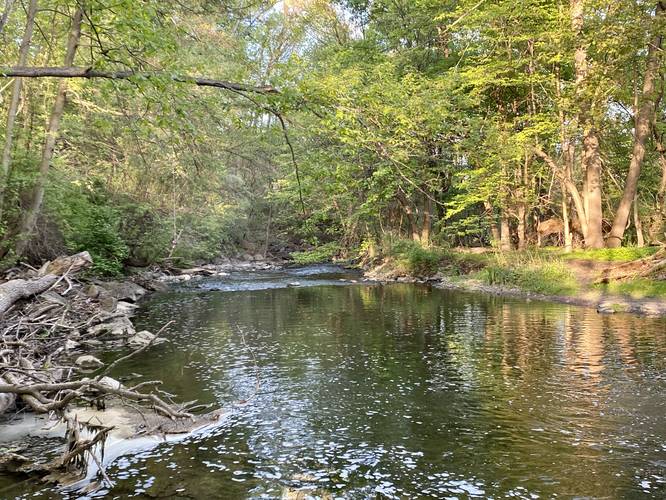
At mile 0.7, hikers will reach the junction with the Perimeter Trail. Here, this GPS track heads left to explore the rest of the park before reaching the waterfalls; however, you can choose your own adventure. To follow this hike, take a left-hand turn here and the Perimeter Trail will meander its way through a boardwalk wetland area before it bends around to reach Allen's Creek at mile 1.2.
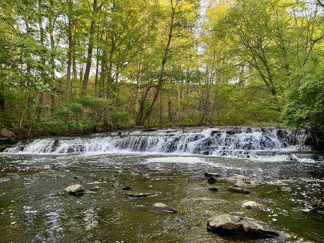
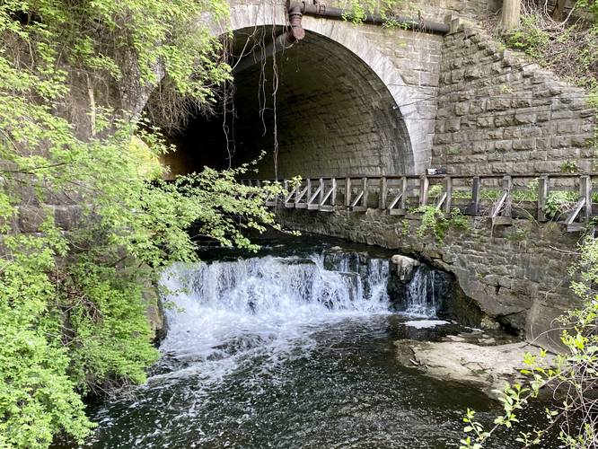
Waterfalls - Mile 1.3 and 1.45
At mile 1.3, hikers will reach a spur trail that leads to the view of a beautiful 4-foot tall and ~60-foot wide waterfall that cascades down Allen's Creek. This is the first of two waterfalls that, as of May 2023, are accessible to the public. Note that there are at least two other waterfalls that are inaccessible as of May 2023 due to a vegetative regrowth area, so please stay on-trail. Just upstream, however, is another publicly-accessible waterfall that spills down at about 4-feet tall and 10-feet wide at the entrance of the railroad tunnel.
After exploring the waterfalls, hikers will head down the Perimeter Trail to connect back to the out-and-back section of the Long Woodchip Trail.
Western Loops - Mile 1.7 to 2.2
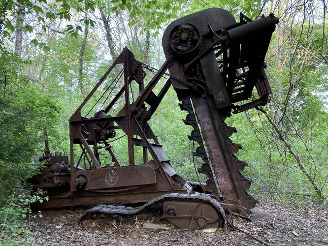
At mile 1.7, hikers can choose to explore the western side of the two loop trails you hiked in on (as this GPS track follows). The most noteworthy point-of-interest along this section of trails is the old rusty machinery that was used to build the railroad adjacent to the park. After the machinery, the interesting parts of the hike are over and hikers will want to head back to parking. Keep left at most trail junctions, except for the spur trail at mile 2 (which leads to a different parking lot). Finally, hikers will reach the main parking lot at mile 2.2.
Parking
Hikers will find a small parking lot at the coordinates provided. The lot is large enough to fit less than a dozen vehicles, max. There's another parking lot located at 43.135877, -77.528685.
Pets
Dogs are allowed if leashed and must be cleaned up after.
Trails This hike follows several named trails in the following order: Stone Dust Loop, Woodchip Loop, Long Woodchip Loop, Perimeter Trail. On the hike out from the Perimeter Trail hikers will follow the Long Woodchip Trail and the western side of the Woodchip Loop and Stone Dust Loop to reach parking.
Hike Description
This hike begins at the northern (main) parking lot for Corbett's Glen Nature Park and follows the Stone Dust Loop in. On the way to the waterfalls, this hike follows the northern-most part of each loop before reaching the Long Woodchip Trail. For the most part, the trails don't have too much to see along the way; however, as of May 2023 at mile 0.1 was a large teepee-like structure made of large pine branches.
Historical Plaque - Mile 0.3
At mile 0.3 is an informational plaque about the history of the land and how it got its name.
Long Woodchip Trail - Mile 0.45
At mile 0.45, hikers will reach the Long Woodchip Trail which is an out-and-back trail that connects both loops in the park.
Ravine Hill - Mile 0.6
Around mile 0.6 is a dip in the trail that leads into a ravine - this is noted simply for the steeper elevation change and likely the "hardest" section on the trail.
Perimeter Trail Junction - Mile 0.7
At mile 0.7, hikers will reach the junction with the Perimeter Trail. Here, this GPS track heads left to explore the rest of the park before reaching the waterfalls; however, you can choose your own adventure. To follow this hike, take a left-hand turn here and the Perimeter Trail will meander its way through a boardwalk wetland area before it bends around to reach Allen's Creek at mile 1.2.
Waterfalls - Mile 1.3 and 1.45
At mile 1.3, hikers will reach a spur trail that leads to the view of a beautiful 4-foot tall and ~60-foot wide waterfall that cascades down Allen's Creek. This is the first of two waterfalls that, as of May 2023, are accessible to the public. Note that there are at least two other waterfalls that are inaccessible as of May 2023 due to a vegetative regrowth area, so please stay on-trail. Just upstream, however, is another publicly-accessible waterfall that spills down at about 4-feet tall and 10-feet wide at the entrance of the railroad tunnel.
After exploring the waterfalls, hikers will head down the Perimeter Trail to connect back to the out-and-back section of the Long Woodchip Trail.
Western Loops - Mile 1.7 to 2.2
At mile 1.7, hikers can choose to explore the western side of the two loop trails you hiked in on (as this GPS track follows). The most noteworthy point-of-interest along this section of trails is the old rusty machinery that was used to build the railroad adjacent to the park. After the machinery, the interesting parts of the hike are over and hikers will want to head back to parking. Keep left at most trail junctions, except for the spur trail at mile 2 (which leads to a different parking lot). Finally, hikers will reach the main parking lot at mile 2.2.
Parking
Hikers will find a small parking lot at the coordinates provided. The lot is large enough to fit less than a dozen vehicles, max. There's another parking lot located at 43.135877, -77.528685.
Pets
Dogs are allowed if leashed and must be cleaned up after.