The Coquina Loop (Old Levi Mill Waterfall) at Poinsett State Park in Sumter County, South Carolina is a moderate 1.7-mile loop hike that features an old mill waterfall and views of Old Levi Mill Lake.
Trails
This hike follows one named trail: Coquina Trail (yellow blazes).
Hike
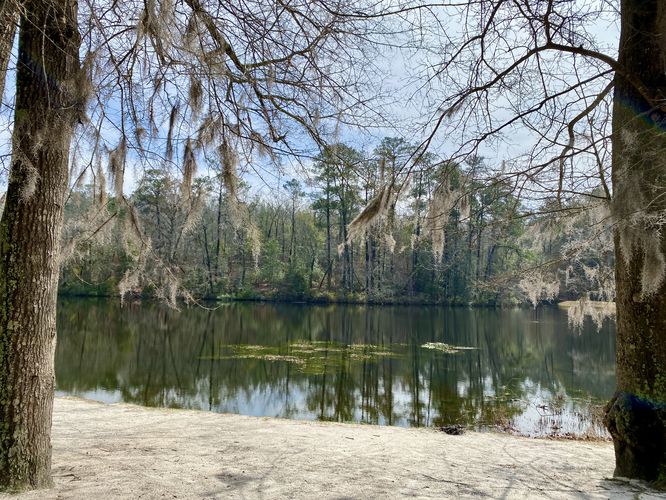
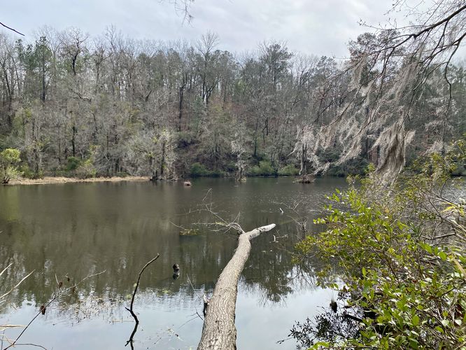
This hike begins at the main parking lot at Poinsett State Park where hikers can walk in toward the trailhead kiosk. Just beyond the trailhead kiosk is a nice view of Old Levi Mill Lake, where hikers can stop first. Just beyond the lake is the first, and most-scenic, spillway (waterfall) at the park.
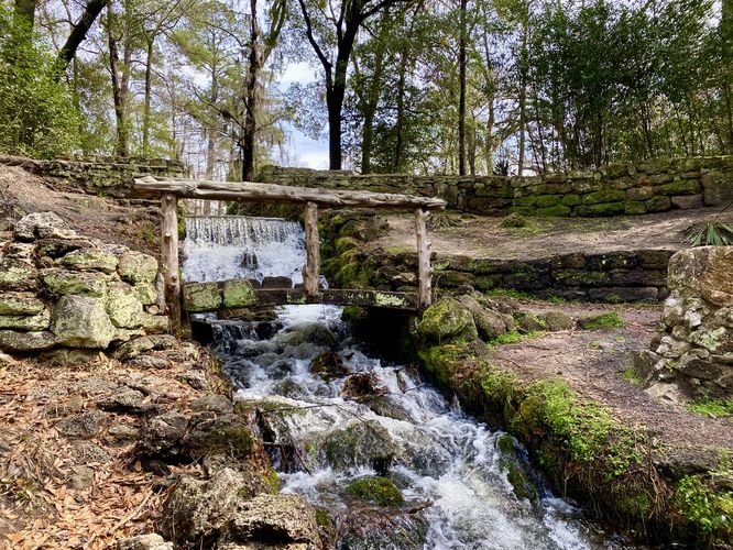
Old Mill Spillway (Waterfall) - Mile 0.15
Hikers will head west from Old Levi Mill Lake to find a stonework spillway that leads water out of the lake and down a nearby brook. Here, you can walk down a series of steps to view the scenic 6-foot tall waterfall spillway - the Old Levi Mill Waterfall. This spillway was human-made during the 1930's CCC era when the park was being constructed; however, it was built directly over an existing mill spillway that was used since 1761. An old mill once stood on this site which provided nearby plantations access to mill corn and grains. Today, this ~90-year old waterfall is one of the most scenic attractions at Poinsett State Park, but is not the last point-of-interest along this hike.
After exploring the old mill waterfall, hikers will walk along the Coquina Trail as it encompasses Old Levi Mill Lake. Soon, the trail will head into the woods to cross a wooden bridge that spans another spillway creek.
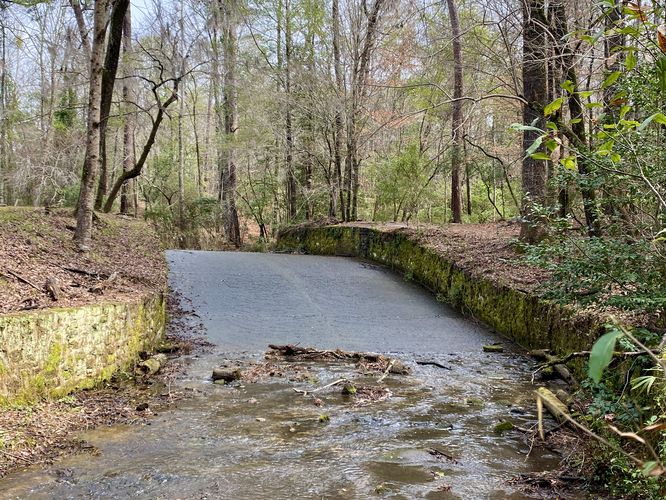
8-foot tall Spillway Waterfall - Mile 0.35
At mile 0.35, hikers will find the silent 8-foot tall slide waterfall that acts as another spillway from Old Levi Mill Lake. Despite being another human-made waterfall, this spillway is another scenic stop along the hike. The water cascades down the slide waterfall with almost complete silence as its surrounded by rock walls on either bank to prevent the forest floor from collapsing-in on the creek.
After passing the second spillway, hikers will want to stay on the yellow-blazed Coquina Trail. Keep an eye out for signage as soon after the second spillway is a left-hand turn that leads up the nearby hill. Once at the top of the hill, keep-right to head toward the 1930's CCC shelter.
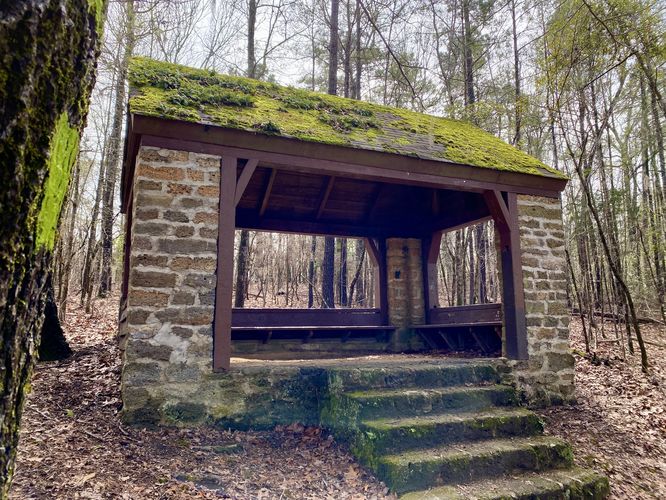
CCC Shelter - Mile 0.75
Around mile 0.75, hikers will reach a shelter built in the 1930s by the CCC. This shelter is for day-use only, but includes benches inside. The original structure still stands -- likely just the stonework -- as the roof must have been replaced since then and the benches likely would be newer as well; however, it's a neat structure tucked away in the middle of the Poinsett woodlands.
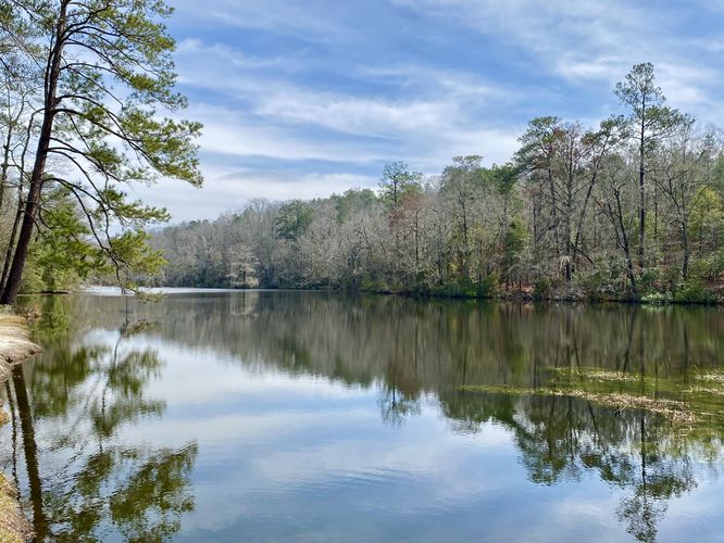
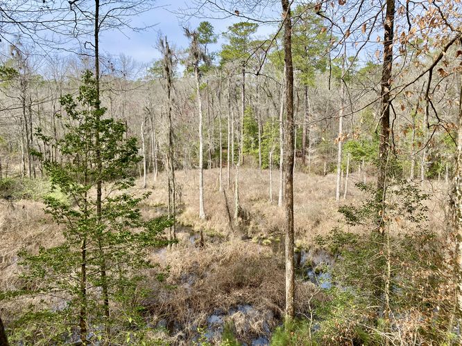
After exploring the CCC Shelter, hikers will head back down the hill -- keeping left at the Coquina Trail junctions -- to make their way back down to Old Levi Mill Lake. Along the way is one "view" of the eastern swamp that feeds the lake, located around mile 1.15. After that, the trail crosses the swamp via a long boardwalk - be on the lookout for alligators here. Then the trail heads left (westward) as it runs along the north shore of Old Levi Mill Lake. This section of the trail has one off-trail view of the lake - again, be on the lookout for alligators and rattlesnakes. Finally, the trail meets up back with the trailhead to complete the hike at 1.7-miles.
Fees
As of March 2024, there's a $6/vehicle parking fee. You'll find a pay station kiosk as you drive into the main parking lot.
Parking
Hikers will find a very large parking lot at the coordinates provided, located at the end of Poinsett Park Road in Sumter County, SC. The lot is large enough to fit several dozen vehicles.
Pets
Dogs are allowed if leashed and must be cleaned up after.
Warnings
Alligators: Note that this trail circles a lake where alligators live. They could be out sunning on the banks of Old Levi Mill Lake or basking in other warm sunny places. Be on the lookout and give any alligator you find plenty of space (~60-feet).
Mosquitos: During warm months, you may find that mosquitos are a real pest along this trail.
Rattlesnakes: The Timber Rattlesnake lives in these areas, especially near water sources. Be on the lookout for any rattlers and give any you find plenty of space.
Trails
This hike follows one named trail: Coquina Trail (yellow blazes).
Hike
This hike begins at the main parking lot at Poinsett State Park where hikers can walk in toward the trailhead kiosk. Just beyond the trailhead kiosk is a nice view of Old Levi Mill Lake, where hikers can stop first. Just beyond the lake is the first, and most-scenic, spillway (waterfall) at the park.
Old Mill Spillway (Waterfall) - Mile 0.15
Hikers will head west from Old Levi Mill Lake to find a stonework spillway that leads water out of the lake and down a nearby brook. Here, you can walk down a series of steps to view the scenic 6-foot tall waterfall spillway - the Old Levi Mill Waterfall. This spillway was human-made during the 1930's CCC era when the park was being constructed; however, it was built directly over an existing mill spillway that was used since 1761. An old mill once stood on this site which provided nearby plantations access to mill corn and grains. Today, this ~90-year old waterfall is one of the most scenic attractions at Poinsett State Park, but is not the last point-of-interest along this hike.
After exploring the old mill waterfall, hikers will walk along the Coquina Trail as it encompasses Old Levi Mill Lake. Soon, the trail will head into the woods to cross a wooden bridge that spans another spillway creek.
8-foot tall Spillway Waterfall - Mile 0.35
At mile 0.35, hikers will find the silent 8-foot tall slide waterfall that acts as another spillway from Old Levi Mill Lake. Despite being another human-made waterfall, this spillway is another scenic stop along the hike. The water cascades down the slide waterfall with almost complete silence as its surrounded by rock walls on either bank to prevent the forest floor from collapsing-in on the creek.
After passing the second spillway, hikers will want to stay on the yellow-blazed Coquina Trail. Keep an eye out for signage as soon after the second spillway is a left-hand turn that leads up the nearby hill. Once at the top of the hill, keep-right to head toward the 1930's CCC shelter.
CCC Shelter - Mile 0.75
Around mile 0.75, hikers will reach a shelter built in the 1930s by the CCC. This shelter is for day-use only, but includes benches inside. The original structure still stands -- likely just the stonework -- as the roof must have been replaced since then and the benches likely would be newer as well; however, it's a neat structure tucked away in the middle of the Poinsett woodlands.
After exploring the CCC Shelter, hikers will head back down the hill -- keeping left at the Coquina Trail junctions -- to make their way back down to Old Levi Mill Lake. Along the way is one "view" of the eastern swamp that feeds the lake, located around mile 1.15. After that, the trail crosses the swamp via a long boardwalk - be on the lookout for alligators here. Then the trail heads left (westward) as it runs along the north shore of Old Levi Mill Lake. This section of the trail has one off-trail view of the lake - again, be on the lookout for alligators and rattlesnakes. Finally, the trail meets up back with the trailhead to complete the hike at 1.7-miles.
Fees
As of March 2024, there's a $6/vehicle parking fee. You'll find a pay station kiosk as you drive into the main parking lot.
Parking
Hikers will find a very large parking lot at the coordinates provided, located at the end of Poinsett Park Road in Sumter County, SC. The lot is large enough to fit several dozen vehicles.
Pets
Dogs are allowed if leashed and must be cleaned up after.
Warnings
Alligators: Note that this trail circles a lake where alligators live. They could be out sunning on the banks of Old Levi Mill Lake or basking in other warm sunny places. Be on the lookout and give any alligator you find plenty of space (~60-feet).
Mosquitos: During warm months, you may find that mosquitos are a real pest along this trail.
Rattlesnakes: The Timber Rattlesnake lives in these areas, especially near water sources. Be on the lookout for any rattlers and give any you find plenty of space.