Copeland Falls Trail at Rocky Mountain National Park near Allenspark, Colorado is an easy 1-mile out-and-back hike that leads to two waterfalls - Lower and Upper Copeland Falls.
Trails
This hike follows the officially-named Wild Basin Trail to reach Copeland Falls.
Hike
This hike begins at the very end of Wild Basin Road at the Wild Basin trailhead. Hikers will find the trailhead located on the south side of the parking lot. The trail heads into the woods by first crossing two footbridges that span a split in North Saint Vrain Creek. Just beyond the footbridge are signs for hiking destinations, including Copeland Falls.
The trail meanders through the woods heading westward, passing at least one creek along the way - which has a footbridge. During late Spring, hikers may find purple clematis alpina wildflowers as they climb their vines and add color to the evergreen-dominant forest.
Lower Copeland Falls - Mile 0.38
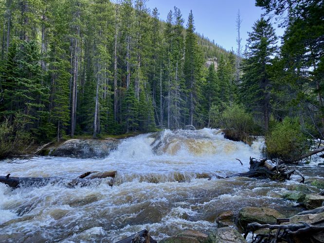
At mile 0.35, hikers will find a sign labeled "Copeland Falls". Take this left-hand turn to head to Lower Copeland Falls which can be found downhill at about mile 0.38. The view of Lower Copeland Falls is downstream of the cascade, approximately 100-feet away; however, this vantage point of the waterfall is perfect for viewing the cascade and the upstream waters. Lower Copeland Falls is about 8-feet tall or slightly shorter, but spans the entire North Saint Vrain Creek. During periods of snow melt, the creek is generally rushing and overflowing, making for quite the roaring waterfall despite its lack of height.
Hiking to Upper Copeland Falls - Mile 0.38 to 0.5
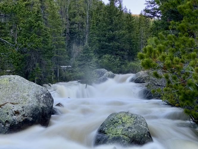
After visiting Lower Copeland Falls, hikers may want to spend a bit more time on the trail to explore Upper Copeland Falls located just over a tenth of a mile west. This track follows the signage for Upper Copeland Falls and completes a small loop back to a southern pathway that runs adjacent to the creek to reach the upper falls area. At mile 0.5, hikers will be on a rock ledge located just downstream of Upper Copeland Falls where you'll find this multi-tiered waterfall cascading down North Saint Vrain Creek. The viewing area again is downstream from the waterfall, this time about 200-feet away; however, this safe distance is necessary for your own safety as the creek's strength, especially during snow melt, cannot be trusted to get much closer. Here, you can enjoy the cascades in all of its glory before hiking back.
Hiking Out - Mile 0.5 to 1
This hike out follows the same path that we hiked in on. There's a very short loop that you can complete if you hike westward from Upper Copeland Falls; however due to lack of daylight, we opted for heading out the way we hiked in to reduce the time and mileage.
Pets
Dogs are not allowed on this trail.
Parking
Hikers will find a massive parking lot at the coordinates provided, located within the Wild Basin section of the park right at the end of County Highway 115. The lot is large enough to fit a few dozen vehicles.
Wildlife Viewing
This trail is great for viewing wildlife, especially deer, elk, and moose due to creek's water source for drinking. If you wish to spot wildlife, your best chances are in the early morning or in the early evening. Always keep a safe distance while viewing - approx. 75-feet for elk and longhorn sheep; 120-feet for bear and moose.
Timed-Entry Reservations
Between the months of late May through early October you must purchase a timed-entry pass to visit Rocky Mountain National Park. If you wish to visitor and hike anything off of the Bear Lake Road, you must purchase a dedicated Bear Lake timed-entry pass. You can find more information about timed entry on the park's website.
Restrooms
As of June 2024, there are restroom facilities at the parking lot.
Warnings
Elevation sickness: This trail brings hikers through terrain that ascends up to 8,700-feet above sea level. Around the 7,000-foot mark above sea level, hikers may start to experience symptoms of elevation sickness including headache, muscle aches, shortness of breath, among other warning signs. In order to avoid elevation sickness it's recommended to ascend to higher elevations and take short walks to acclimate over the course of several days before taking a long or physically-demanding hike. At any time you feel elevation sickness kicking in, that's the time to turn back and head for lower altitude or the parking lot.
Wild animals: While rare, hikers may encounter bears or mountain lion along the trail. This is rare due to the large amount of people who hike these trails each day; however, it's smart to know that these wild animals could be on-trail. Please read-up on how to properly handle a bear or mountain lion encounter before hitting the trails.
Trails
This hike follows the officially-named Wild Basin Trail to reach Copeland Falls.
Hike
This hike begins at the very end of Wild Basin Road at the Wild Basin trailhead. Hikers will find the trailhead located on the south side of the parking lot. The trail heads into the woods by first crossing two footbridges that span a split in North Saint Vrain Creek. Just beyond the footbridge are signs for hiking destinations, including Copeland Falls.
The trail meanders through the woods heading westward, passing at least one creek along the way - which has a footbridge. During late Spring, hikers may find purple clematis alpina wildflowers as they climb their vines and add color to the evergreen-dominant forest.
Lower Copeland Falls - Mile 0.38
At mile 0.35, hikers will find a sign labeled "Copeland Falls". Take this left-hand turn to head to Lower Copeland Falls which can be found downhill at about mile 0.38. The view of Lower Copeland Falls is downstream of the cascade, approximately 100-feet away; however, this vantage point of the waterfall is perfect for viewing the cascade and the upstream waters. Lower Copeland Falls is about 8-feet tall or slightly shorter, but spans the entire North Saint Vrain Creek. During periods of snow melt, the creek is generally rushing and overflowing, making for quite the roaring waterfall despite its lack of height.
Hiking to Upper Copeland Falls - Mile 0.38 to 0.5
After visiting Lower Copeland Falls, hikers may want to spend a bit more time on the trail to explore Upper Copeland Falls located just over a tenth of a mile west. This track follows the signage for Upper Copeland Falls and completes a small loop back to a southern pathway that runs adjacent to the creek to reach the upper falls area. At mile 0.5, hikers will be on a rock ledge located just downstream of Upper Copeland Falls where you'll find this multi-tiered waterfall cascading down North Saint Vrain Creek. The viewing area again is downstream from the waterfall, this time about 200-feet away; however, this safe distance is necessary for your own safety as the creek's strength, especially during snow melt, cannot be trusted to get much closer. Here, you can enjoy the cascades in all of its glory before hiking back.
Hiking Out - Mile 0.5 to 1
This hike out follows the same path that we hiked in on. There's a very short loop that you can complete if you hike westward from Upper Copeland Falls; however due to lack of daylight, we opted for heading out the way we hiked in to reduce the time and mileage.
Pets
Dogs are not allowed on this trail.
Parking
Hikers will find a massive parking lot at the coordinates provided, located within the Wild Basin section of the park right at the end of County Highway 115. The lot is large enough to fit a few dozen vehicles.
Wildlife Viewing
This trail is great for viewing wildlife, especially deer, elk, and moose due to creek's water source for drinking. If you wish to spot wildlife, your best chances are in the early morning or in the early evening. Always keep a safe distance while viewing - approx. 75-feet for elk and longhorn sheep; 120-feet for bear and moose.
Timed-Entry Reservations
Between the months of late May through early October you must purchase a timed-entry pass to visit Rocky Mountain National Park. If you wish to visitor and hike anything off of the Bear Lake Road, you must purchase a dedicated Bear Lake timed-entry pass. You can find more information about timed entry on the park's website.
Restrooms
As of June 2024, there are restroom facilities at the parking lot.
Warnings
Elevation sickness: This trail brings hikers through terrain that ascends up to 8,700-feet above sea level. Around the 7,000-foot mark above sea level, hikers may start to experience symptoms of elevation sickness including headache, muscle aches, shortness of breath, among other warning signs. In order to avoid elevation sickness it's recommended to ascend to higher elevations and take short walks to acclimate over the course of several days before taking a long or physically-demanding hike. At any time you feel elevation sickness kicking in, that's the time to turn back and head for lower altitude or the parking lot.
Wild animals: While rare, hikers may encounter bears or mountain lion along the trail. This is rare due to the large amount of people who hike these trails each day; however, it's smart to know that these wild animals could be on-trail. Please read-up on how to properly handle a bear or mountain lion encounter before hitting the trails.