The Conklin's Gully Loop at High Tor Wildlife Management Area in Naples, New York is a difficult 2.4-mile loop trail that features views from the rim of Conklin's Gully along with views of waterfalls that sit ~200-feet in the gorge below.
Trails
This hike follows an unnamed trail blazed yellow. The official trail ends on Parrish Hill Road, where this route leads hikers back to parking via the road.
Hike
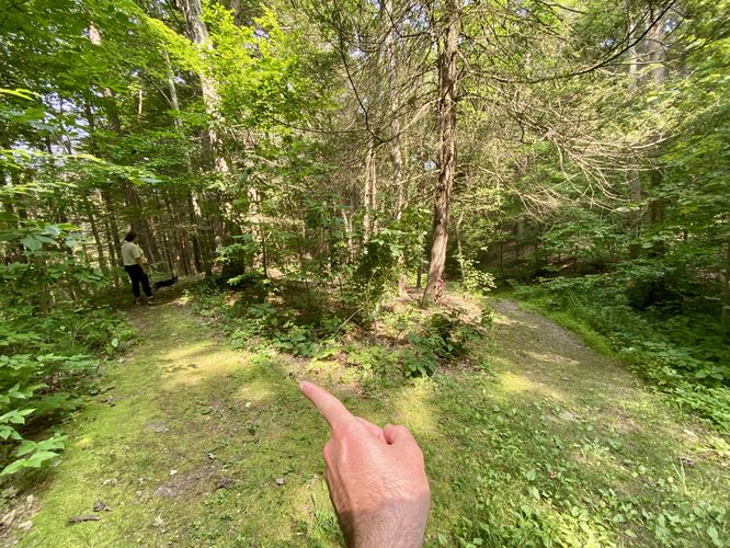
This hike begins at the main parking lot for Conklin's Gully, located at the parking coordinates provided. The trail can be found on the far side of the parking lot where hikers will find an information kiosk. As of July 2024, the trailhead kiosk isn't super helpful as the map provided includes very-little detail on the trail that encompasses Conklin's Gully. If you're using a hiking app, like the MyHikes app, you'll find the proper route to hike without much worry.
Steep Uphill - Mile 0 to 0.55
From the trailhead to mile ~0.55, hikers will be faced with a very-steep uphill climb. This will definitely get your heart pumping and will quickly make you sweat if hiking in warm months, like the summer. The way up provides an offshoot yellow-blazed path that this route takes to alleviate some of the elevation gain; however, if you stay on the rim-side of the trail, it'll be more difficult. This section of the trail is by-far the most difficult, hence the "Hard" difficulty rating.
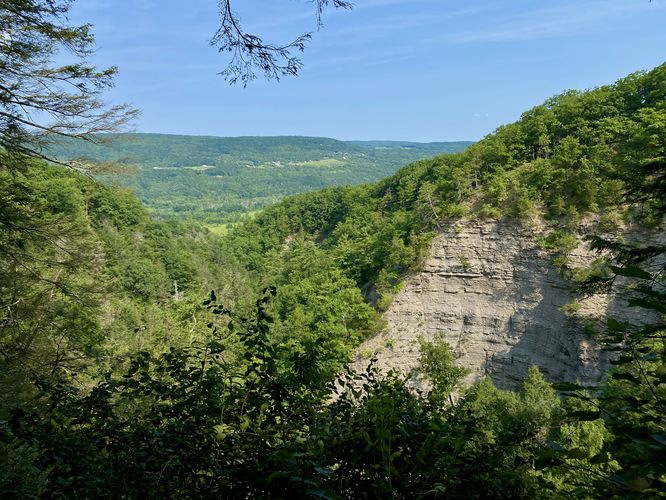
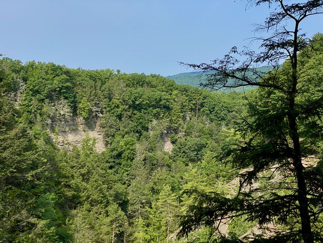
Waterfall & Vista - Mile 0.6
At mile 0.6, hikers will have traversed up the steepest section of the trail to reach a bend in the main path that includes a short out-and-back offshoot trail. This offshoot leads hikers directly to the ~200-foot tall sheer ledge of Conklin's Gully and provides a stunning view of the gorge and the mountains and hills that surround this part of Naples, New York. During snowmelt season, or after very heavy rainfall, you'll also find a waterfall that spills into the gorge here; however, you cannot get a good view of the waterfall as it plunges into the gorge, hence I took no pictures of the dried-up top ledge.
Short Seasonal Waterfall - Mile 0.7
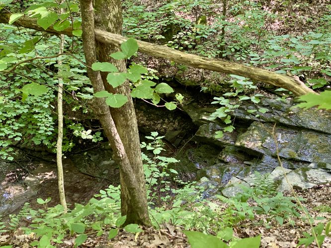
After exploring the first vista, the trail leads through an open meadow before it passes through the forest once more. Around mile 0.7, hikers will pass a short ~6-foot tall waterfall that cascades down the bedrock of the adjacent seasonal creek. During snowmelt season or after very-heavy rainfall, this waterfall should be flowing but was dried-up during our hike here in July.
After passing the tributary creek waterfall, the trail stays in the forest and reaches a fork in the path. At the fork, this route leads hikers along the rim of Conklin's Gully instead of taking the shorter bypass, but both lead to the same place -- a waterfall and vista.
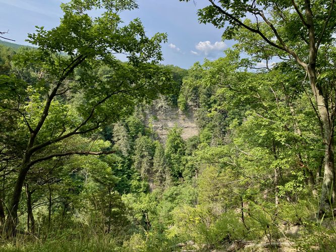
Waterfall View - Mile 0.9
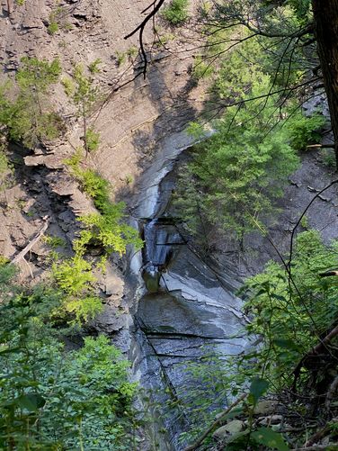
At mile 0.9, hikers will reach an opening in the gorge's rim where you'll find waterfalls flowing down the bedrock at the bottom of Conklin's Gully. It's difficult to tell how tall these cascades are - the upper waterfall appears to be ~10-feet tall with a ~15 to 20-foot tall slide waterfall below it. You can view the waterfall from the rim, which sits about 200-feet above, so the view isn't spectacular but it's the only legal way to view these cascades.
Conklin's Gully Vista - Mile 0.91 to 0.94
After passing around the bend from the waterfall view, hikers will be presented with another view into Conklin's Gully. Here, you'll find the same waterfall you just saw below your feet, however, from this view you can't see the entire cascades. The view lasts for ~100 feet or so between mile 0.91 to 0.94.
Forest Hiking to the Footbridge - Mile 0.94 to 1.12
From the vista at mile 0.94, the hike from here for the next mile or so is mostly all forest hiking. Between mile 0.94 and 1.12, hikers will head into the forest, following the yellow-blazed trail, before it reaches a skinnier path. This skinny path leads downhill, following a root-filled / slightly-overgrowth trail down to main creek where a footbridge crosses to reach the northern side of Conklin's Gully.
Switchbacks to Spur Trail - Mile 1.12 to 1.27
From mile 1.12 to 1.27, hikers will head along the yellow blazes following a switchback up the hillside. At the top of the hill, you'll find a trail junction with a left-hand turn to complete the loop or a right-hand turn to head down a spur trail. This route leads down the spur trail to attempt to explore the waterfalls that sit near the end of the path. For most hikers, you can skip this part of the route and instead take a left-hand turn!
Spur Trail to Waterfalls - Mile 1.27 to 1.7
The spur trail included in this route is really not worth checking out for several reasons - it's a bit overgrown, not maintained, very very buggy during warm months, and leads to a dead-end. The waterfalls depicted on the map tiles provided do exist, I could hear the water cascading from the trail; however, the forest is quite overgrown and provides no real way to see or explore the waterfalls during warm months. This may be more interesting during cooler months when little vegetation is growing in the forest, which would allow easier exploring off-trail. This spur starts in the route around mile 1.27 and ends at the same junction around mile 1.7.
Left-Hand Turn to Hike to Parking - Mile 1.7
Despite the mileage, once you reach the top junction you can head down the yellow blazed trail to reach parking. Hikers will be faced with a fork in the trail where you will want to keep-left. Taking the right-hand turn here will lead you very far away from parking. The indicator that you're on the right path is that the proper path leads up along a sloped hill that sits above the two adjacent trails. Hike this route to stay on the yellow blazed loop.
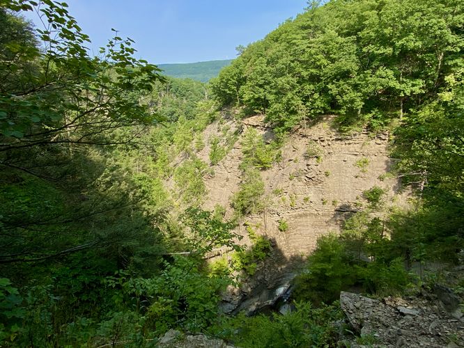
Conklin's Gully View - Mile 2
Around mile 2, on the north rim of the gorge, hikers will find a decent view of Conklin's Gully. You can explore a bit further off-trail to potentially find more or better views by heading down toward the canyon's rim but do so at your own risk.
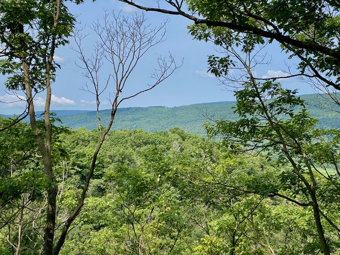
Naples Hills Views - Mile 2.07
Just down the trail to the west is a decent view of the neighboring hills in Naples, NY from the gorge's rim that peers through the trees.
After passing the last vista, the trail leads downhill to reach Parrish Hill Road and follows a steep grade on the way down. Once you reach the road, this track leads down the road and around the corner to reach the parking lot for a difficult 2.7-mile loop hike.
Parking
Hikers will find a large parking lot at the coordinates provided, located on the south side of NY-245 in Naples, New York. The lot is large enough to fit a couple dozen vehicles as of July 2024.
Pets
Dogs are allowed only if leashed and must be cleaned up after.
Warning
Steep cliffs: This hike leads along the rim of very tall (~200-foot) cliffs that have sheer drop-offs into Conklin's Gully. You must hike at your own risk at all times.
Timber Rattlesnake: This area is home to the Timber Rattlesnake which can be found roaming the forest between the end of April to early October each year. While rare, be on the lookout and give any rattlers you find plenty of space.
Popularity
This hike is one of the more popular day hikes in the Naples, New York area, especially during the weekend. Plan on seeing other hikers here as the parking lot tends to fill up, at least half-way, by 10AM on weekends.
Trails
This hike follows an unnamed trail blazed yellow. The official trail ends on Parrish Hill Road, where this route leads hikers back to parking via the road.
Hike
This hike begins at the main parking lot for Conklin's Gully, located at the parking coordinates provided. The trail can be found on the far side of the parking lot where hikers will find an information kiosk. As of July 2024, the trailhead kiosk isn't super helpful as the map provided includes very-little detail on the trail that encompasses Conklin's Gully. If you're using a hiking app, like the MyHikes app, you'll find the proper route to hike without much worry.
Steep Uphill - Mile 0 to 0.55
From the trailhead to mile ~0.55, hikers will be faced with a very-steep uphill climb. This will definitely get your heart pumping and will quickly make you sweat if hiking in warm months, like the summer. The way up provides an offshoot yellow-blazed path that this route takes to alleviate some of the elevation gain; however, if you stay on the rim-side of the trail, it'll be more difficult. This section of the trail is by-far the most difficult, hence the "Hard" difficulty rating.
Waterfall & Vista - Mile 0.6
At mile 0.6, hikers will have traversed up the steepest section of the trail to reach a bend in the main path that includes a short out-and-back offshoot trail. This offshoot leads hikers directly to the ~200-foot tall sheer ledge of Conklin's Gully and provides a stunning view of the gorge and the mountains and hills that surround this part of Naples, New York. During snowmelt season, or after very heavy rainfall, you'll also find a waterfall that spills into the gorge here; however, you cannot get a good view of the waterfall as it plunges into the gorge, hence I took no pictures of the dried-up top ledge.
Short Seasonal Waterfall - Mile 0.7
After exploring the first vista, the trail leads through an open meadow before it passes through the forest once more. Around mile 0.7, hikers will pass a short ~6-foot tall waterfall that cascades down the bedrock of the adjacent seasonal creek. During snowmelt season or after very-heavy rainfall, this waterfall should be flowing but was dried-up during our hike here in July.
After passing the tributary creek waterfall, the trail stays in the forest and reaches a fork in the path. At the fork, this route leads hikers along the rim of Conklin's Gully instead of taking the shorter bypass, but both lead to the same place -- a waterfall and vista.
Waterfall View - Mile 0.9
At mile 0.9, hikers will reach an opening in the gorge's rim where you'll find waterfalls flowing down the bedrock at the bottom of Conklin's Gully. It's difficult to tell how tall these cascades are - the upper waterfall appears to be ~10-feet tall with a ~15 to 20-foot tall slide waterfall below it. You can view the waterfall from the rim, which sits about 200-feet above, so the view isn't spectacular but it's the only legal way to view these cascades.
Conklin's Gully Vista - Mile 0.91 to 0.94
After passing around the bend from the waterfall view, hikers will be presented with another view into Conklin's Gully. Here, you'll find the same waterfall you just saw below your feet, however, from this view you can't see the entire cascades. The view lasts for ~100 feet or so between mile 0.91 to 0.94.
Forest Hiking to the Footbridge - Mile 0.94 to 1.12
From the vista at mile 0.94, the hike from here for the next mile or so is mostly all forest hiking. Between mile 0.94 and 1.12, hikers will head into the forest, following the yellow-blazed trail, before it reaches a skinnier path. This skinny path leads downhill, following a root-filled / slightly-overgrowth trail down to main creek where a footbridge crosses to reach the northern side of Conklin's Gully.
Switchbacks to Spur Trail - Mile 1.12 to 1.27
From mile 1.12 to 1.27, hikers will head along the yellow blazes following a switchback up the hillside. At the top of the hill, you'll find a trail junction with a left-hand turn to complete the loop or a right-hand turn to head down a spur trail. This route leads down the spur trail to attempt to explore the waterfalls that sit near the end of the path. For most hikers, you can skip this part of the route and instead take a left-hand turn!
Spur Trail to Waterfalls - Mile 1.27 to 1.7
The spur trail included in this route is really not worth checking out for several reasons - it's a bit overgrown, not maintained, very very buggy during warm months, and leads to a dead-end. The waterfalls depicted on the map tiles provided do exist, I could hear the water cascading from the trail; however, the forest is quite overgrown and provides no real way to see or explore the waterfalls during warm months. This may be more interesting during cooler months when little vegetation is growing in the forest, which would allow easier exploring off-trail. This spur starts in the route around mile 1.27 and ends at the same junction around mile 1.7.
Left-Hand Turn to Hike to Parking - Mile 1.7
Despite the mileage, once you reach the top junction you can head down the yellow blazed trail to reach parking. Hikers will be faced with a fork in the trail where you will want to keep-left. Taking the right-hand turn here will lead you very far away from parking. The indicator that you're on the right path is that the proper path leads up along a sloped hill that sits above the two adjacent trails. Hike this route to stay on the yellow blazed loop.
Conklin's Gully View - Mile 2
Around mile 2, on the north rim of the gorge, hikers will find a decent view of Conklin's Gully. You can explore a bit further off-trail to potentially find more or better views by heading down toward the canyon's rim but do so at your own risk.
Naples Hills Views - Mile 2.07
Just down the trail to the west is a decent view of the neighboring hills in Naples, NY from the gorge's rim that peers through the trees.
After passing the last vista, the trail leads downhill to reach Parrish Hill Road and follows a steep grade on the way down. Once you reach the road, this track leads down the road and around the corner to reach the parking lot for a difficult 2.7-mile loop hike.
Parking
Hikers will find a large parking lot at the coordinates provided, located on the south side of NY-245 in Naples, New York. The lot is large enough to fit a couple dozen vehicles as of July 2024.
Pets
Dogs are allowed only if leashed and must be cleaned up after.
Warning
Steep cliffs: This hike leads along the rim of very tall (~200-foot) cliffs that have sheer drop-offs into Conklin's Gully. You must hike at your own risk at all times.
Timber Rattlesnake: This area is home to the Timber Rattlesnake which can be found roaming the forest between the end of April to early October each year. While rare, be on the lookout and give any rattlers you find plenty of space.
Popularity
This hike is one of the more popular day hikes in the Naples, New York area, especially during the weekend. Plan on seeing other hikers here as the parking lot tends to fill up, at least half-way, by 10AM on weekends.