The Boardwalk Loop at Congaree National Park near Hopkins, South Carolina is an easy universally-accessible 2.5-mile loop hike that features beautiful old-growth Bald Cypress, Water Tupelo, and Loblolly Pine, and includes views of Weston Lake.
Universal Access
This boardwalk loop is universally accessible from the parking lot.
Extend Your Hike
Note that this loop is perfect to combine with the Weston Lake Loop for a longer day hike. Note that the Weston Lake Loop exists within the Congaree Wilderness, so you'll be dodging puddles, might get a bit muddy, and should be more cautious about local wildlife like the Timber Rattlesnake.
Hike
This hike begins at the main parking lot and follows the brick pathway to reach the visitors center. On the opposite side of the visitors center, the Boardwalk Loop begins. Here, hikers will follow a short spur trail that leads to the larger loop. Once at the loop junction, around mile 0.25 from the parking lot, hikers can keep right (head straight south) to follow the loop counter-clockwise.
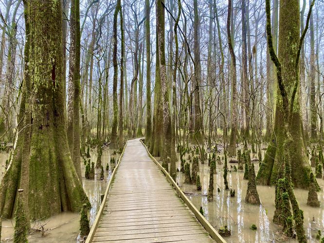
After keeping-right at the start of the loop, hikers will follow the boardwalk as it descends from the raised platform down to water-level. During periods of heavy rains, this section of the trail may be flooded and impassable. The boardwalk meanders its way through the forest before reaching deeper swamps where the old-growth Bald Cypress and Water Tupelo trees grow. You can't miss the oddly-shaped roots or "knees" that grow out of the ground that litter the forest floor and jut straight out of the swamp waters -- these roots belong to the Bald Cypress trees. They're often found covered in moss and small ferns. The jutting roots are believed to help provide extra support and structure to the trees during periods of high winds or flooding, but their purpose is not fully understood.
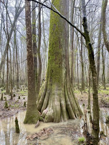
Old-Growth Bald Cypress - Mile 0.45
Around mile 0.45, hikers will find an old-growth Bald Cypress tree growing out of the swamp. It sits off-trail and cannot be missed, simply look for the largest tree around to spot it.
Water Tupelos and Bald Cypress "Knees" - Mile 0.6
Just down the trail from the old-growth Bald Cypress is a section of the trail that passes through deeper swampy flood plains that are littered in Bald Cypress roots ("knees") along with the green moss-covered Water Tupelo. This section of the trail is probably the most-scenic along the entire route. The Water Tupelo are identified with their carpet of green moss that surrounds the base of the trees. These carpets of moss indicate flood plain water lines, so the tops of the moss show how high flood waters have risen in the past. Some of these moss-covered Tupelo show water lines that are ~6 feet tall (from the boardwalk).
After the scenic Water Tupelo and Bald Cypress section of the loop, the trail will curve to head eastward. This section of the trail is a bit less scenic, but leads to some neat points-of-interest further east.
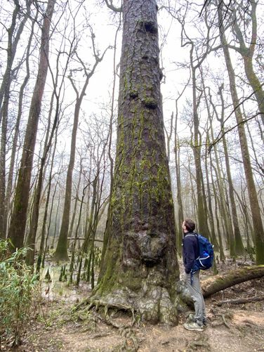
Old-Growth Loblolly Pine - Mile 1.1
At the sign labeled "11", hikers will reach an old-growth Loblolly Pine tree that sits south of the trail. This massive tree is approximately 150-feet tall and also a former state champion.
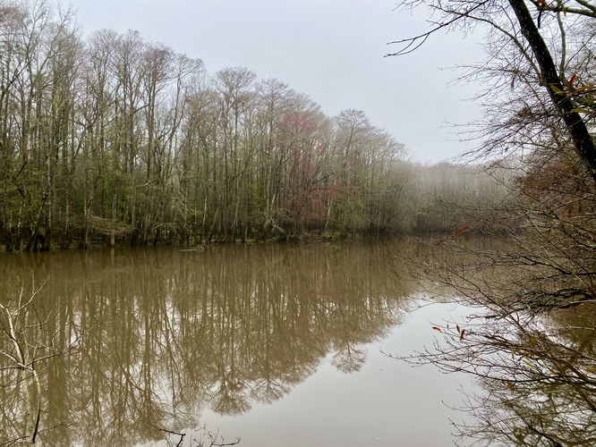
Weston Lake Overlook - Mile 1.23
The trail will eventually pass signage for the Weston Lake Loop - hike past this sign to walk uphill and back to the raised boardwalk. Once on the raised boardwalk, head south to reach a dead-end at the Weston Lake Overlook. From the overlook, during warm months, hikers will get lush views of the trees that surround Weston Lake. You may even find a fish or two jumping out of the water (no fishing permitted). During our hike here in early March, we didn't find much lush greenery but I noticed a few fish jumping in the waters of Weston Lake.
Optional Weston Lake Loop hike
Before continuing onward, if you plan to hike any further into Congaree National Park, you might want to consider hiking the Weston Lake Loop here as the trailhead is located next to the Weston Lake Overlook.
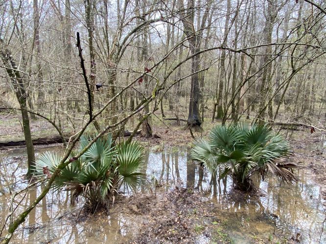
Dwarf Palmetto Grove - Mile 1.35
After visiting the Weston Lake Overlook, hikers will follow the boardwalk as it heads due-north along a raised section of trail. Down below, around mile 1.35, located to the west is a grove of Dwarf Palmetto. These trees add scenery and color to the landscape, especially during colder months.
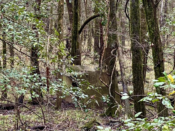
Abandoned Bootlegger Still - Mile 1.6
Around mile 1.6, hikers will find an interpretive sign labeled "15". If you look into the woods to the east, about 200-feet from the trail is a large metal box. This metal box was part of an abandoned moonshine still. During the prohibition era, bootleggers and moonshiners would head into the deep woods, and even the Congaree River floodplain, to create illegal to earn their living.
Completing the Loop
Hikers will continue following the boardwalk as it heads north, passing more old-growth Loblolly Pine along the way. Eventually the trail will reach a junction -- keep left to stay on the boardwalk loop. The boardwalk will pass through one last scenic section of forest where the floor of the forest is covered in moss. Not long after, the trail loops back to the beginning of the Boardwalk Loop. Take a right-hand turn to follow the trail through the visitors center and back to the parking lot for a 2.5-mile hike.
Parking
Hikers will find a couple of large parking lots at the coordinates provided, located at the end of the national park entrance road. The lots are large enough to fit a few dozen vehicles each and they fill up fairly quickly each morning, by 11AM. During our visit here, we arrived at the park at 8:30AM with ~4 other cars in the lot. By the time we finished hiking here, it was about 11AM and almost all of the parking lots were full. If you wish to enjoy the boardwalk loop without many other people, show up early.
Pets
Dogs are allowed if leashed and must be cleaned up after.
Warnings
Mosquitos: Note that Congaree National Park is known for its insane-levels of mosquitos (and other bugs). The visitors center has a mosquito meter located between the two restrooms near the trailhead. The mosquito meter ranges between 1 (All Clear) to 6 (War Zone). If you want to enjoy Congaree National Park with minimal mosquito issues, plan to visit during the winter. During our hike here in early March 2024, we didn't have to deal with any mosquitos. During Summer months, the meter is likely always at 6 "War Zone".
Slippery when wet: The boardwalk can be very slippery when wet.
Flooding: Heavy rains can flood parts of this boardwalk, especially on the western side.
Rattlesnakes: This area is home to the Timber Rattlesnake which can be found sunning itself in open areas or sunny spots on warm days. Despite the popularity of this boardwalk, you could encounter a snake as it roams the forest. If you find a rattlesnake give it plenty of space.
Restrooms
Hikers will find restrooms and flush toilets at the visitors center near the parking lot.
What makes Congaree Special?
Congaree National Park is comprised of floodplains that sit alongside the Congaree River. Historically, these floodplains have been difficult to navigate and plunder for natural resources like timber. Due to the difficulties in logging the floodplain forests, Congaree holds a unique ecosystem of old-growth Bald Cypress and Water Tupelo trees -- along with other old-growth trees native to the eastern United States like various types of Maples. Due to the lack of logging, Congaree also holds one of the tallest deciduous canopies in the world. Tall Loblolly Pine trees also grow in Congaree's floodplains and some even reach as tall as 150-feet high. Congaree's unique swampy ecosystem is also full of various bird species and makes for a very-popular bird watching park. During our visit in March 2024, we saw at least one owl, many cardinals, and various other species of birds that we (being from the north) only see during certain seasons of the year.
Universal Access
This boardwalk loop is universally accessible from the parking lot.
Extend Your Hike
Note that this loop is perfect to combine with the Weston Lake Loop for a longer day hike. Note that the Weston Lake Loop exists within the Congaree Wilderness, so you'll be dodging puddles, might get a bit muddy, and should be more cautious about local wildlife like the Timber Rattlesnake.
Hike
This hike begins at the main parking lot and follows the brick pathway to reach the visitors center. On the opposite side of the visitors center, the Boardwalk Loop begins. Here, hikers will follow a short spur trail that leads to the larger loop. Once at the loop junction, around mile 0.25 from the parking lot, hikers can keep right (head straight south) to follow the loop counter-clockwise.
After keeping-right at the start of the loop, hikers will follow the boardwalk as it descends from the raised platform down to water-level. During periods of heavy rains, this section of the trail may be flooded and impassable. The boardwalk meanders its way through the forest before reaching deeper swamps where the old-growth Bald Cypress and Water Tupelo trees grow. You can't miss the oddly-shaped roots or "knees" that grow out of the ground that litter the forest floor and jut straight out of the swamp waters -- these roots belong to the Bald Cypress trees. They're often found covered in moss and small ferns. The jutting roots are believed to help provide extra support and structure to the trees during periods of high winds or flooding, but their purpose is not fully understood.
Old-Growth Bald Cypress - Mile 0.45
Around mile 0.45, hikers will find an old-growth Bald Cypress tree growing out of the swamp. It sits off-trail and cannot be missed, simply look for the largest tree around to spot it.
Water Tupelos and Bald Cypress "Knees" - Mile 0.6
Just down the trail from the old-growth Bald Cypress is a section of the trail that passes through deeper swampy flood plains that are littered in Bald Cypress roots ("knees") along with the green moss-covered Water Tupelo. This section of the trail is probably the most-scenic along the entire route. The Water Tupelo are identified with their carpet of green moss that surrounds the base of the trees. These carpets of moss indicate flood plain water lines, so the tops of the moss show how high flood waters have risen in the past. Some of these moss-covered Tupelo show water lines that are ~6 feet tall (from the boardwalk).
After the scenic Water Tupelo and Bald Cypress section of the loop, the trail will curve to head eastward. This section of the trail is a bit less scenic, but leads to some neat points-of-interest further east.
Old-Growth Loblolly Pine - Mile 1.1
At the sign labeled "11", hikers will reach an old-growth Loblolly Pine tree that sits south of the trail. This massive tree is approximately 150-feet tall and also a former state champion.
Weston Lake Overlook - Mile 1.23
The trail will eventually pass signage for the Weston Lake Loop - hike past this sign to walk uphill and back to the raised boardwalk. Once on the raised boardwalk, head south to reach a dead-end at the Weston Lake Overlook. From the overlook, during warm months, hikers will get lush views of the trees that surround Weston Lake. You may even find a fish or two jumping out of the water (no fishing permitted). During our hike here in early March, we didn't find much lush greenery but I noticed a few fish jumping in the waters of Weston Lake.
Optional Weston Lake Loop hike
Before continuing onward, if you plan to hike any further into Congaree National Park, you might want to consider hiking the Weston Lake Loop here as the trailhead is located next to the Weston Lake Overlook.
Dwarf Palmetto Grove - Mile 1.35
After visiting the Weston Lake Overlook, hikers will follow the boardwalk as it heads due-north along a raised section of trail. Down below, around mile 1.35, located to the west is a grove of Dwarf Palmetto. These trees add scenery and color to the landscape, especially during colder months.
Abandoned Bootlegger Still - Mile 1.6
Around mile 1.6, hikers will find an interpretive sign labeled "15". If you look into the woods to the east, about 200-feet from the trail is a large metal box. This metal box was part of an abandoned moonshine still. During the prohibition era, bootleggers and moonshiners would head into the deep woods, and even the Congaree River floodplain, to create illegal to earn their living.
Completing the Loop
Hikers will continue following the boardwalk as it heads north, passing more old-growth Loblolly Pine along the way. Eventually the trail will reach a junction -- keep left to stay on the boardwalk loop. The boardwalk will pass through one last scenic section of forest where the floor of the forest is covered in moss. Not long after, the trail loops back to the beginning of the Boardwalk Loop. Take a right-hand turn to follow the trail through the visitors center and back to the parking lot for a 2.5-mile hike.
Parking
Hikers will find a couple of large parking lots at the coordinates provided, located at the end of the national park entrance road. The lots are large enough to fit a few dozen vehicles each and they fill up fairly quickly each morning, by 11AM. During our visit here, we arrived at the park at 8:30AM with ~4 other cars in the lot. By the time we finished hiking here, it was about 11AM and almost all of the parking lots were full. If you wish to enjoy the boardwalk loop without many other people, show up early.
Pets
Dogs are allowed if leashed and must be cleaned up after.
Warnings
Mosquitos: Note that Congaree National Park is known for its insane-levels of mosquitos (and other bugs). The visitors center has a mosquito meter located between the two restrooms near the trailhead. The mosquito meter ranges between 1 (All Clear) to 6 (War Zone). If you want to enjoy Congaree National Park with minimal mosquito issues, plan to visit during the winter. During our hike here in early March 2024, we didn't have to deal with any mosquitos. During Summer months, the meter is likely always at 6 "War Zone".
Slippery when wet: The boardwalk can be very slippery when wet.
Flooding: Heavy rains can flood parts of this boardwalk, especially on the western side.
Rattlesnakes: This area is home to the Timber Rattlesnake which can be found sunning itself in open areas or sunny spots on warm days. Despite the popularity of this boardwalk, you could encounter a snake as it roams the forest. If you find a rattlesnake give it plenty of space.
Restrooms
Hikers will find restrooms and flush toilets at the visitors center near the parking lot.
What makes Congaree Special?
Congaree National Park is comprised of floodplains that sit alongside the Congaree River. Historically, these floodplains have been difficult to navigate and plunder for natural resources like timber. Due to the difficulties in logging the floodplain forests, Congaree holds a unique ecosystem of old-growth Bald Cypress and Water Tupelo trees -- along with other old-growth trees native to the eastern United States like various types of Maples. Due to the lack of logging, Congaree also holds one of the tallest deciduous canopies in the world. Tall Loblolly Pine trees also grow in Congaree's floodplains and some even reach as tall as 150-feet high. Congaree's unique swampy ecosystem is also full of various bird species and makes for a very-popular bird watching park. During our visit in March 2024, we saw at least one owl, many cardinals, and various other species of birds that we (being from the north) only see during certain seasons of the year.