The Coastal Maine Troll Loop at the Coastal Maine Botanical Gardens in Boothbay, Maine is an easy 2.3-mile loop hike that features massive wooden troll structures that reside in the woods.
Hike Description
This hike begins at the main entrance building and follows the boardwalk over wetlands to reach the native butterfly house and gardens. Here, stay right to head north toward the first troll, Roskva.
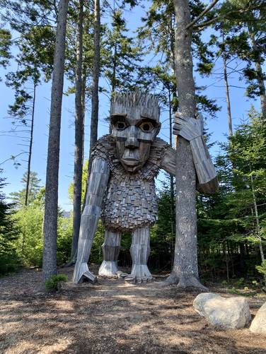
Roskva (Troll) - Mile 0.2
At mile 0.2, hikers will reach the first wood troll, named Roskva. This troll is one of the tallest, if not the tallest, along the walk.
After visiting Roskva, this hike leads to the restaurant pavilion and then skirts around the building to the north to head east once again. When you reach another wide dirt trail junction, take the left-hand turn onto Birch Allee to head toward the next troll, Lilja.
Lilja (Troll) - Mile 0.45
Around mile 0.45, after taking a left-hand turn at the Lilja sign, hikers will reach the 2nd wood troll on the hike, named Lilja. Lilja is supposedly the youngest of the trolls in these woods. After visiting Lilja, head back to the main trail (Birch Allee) you just hiked off of.
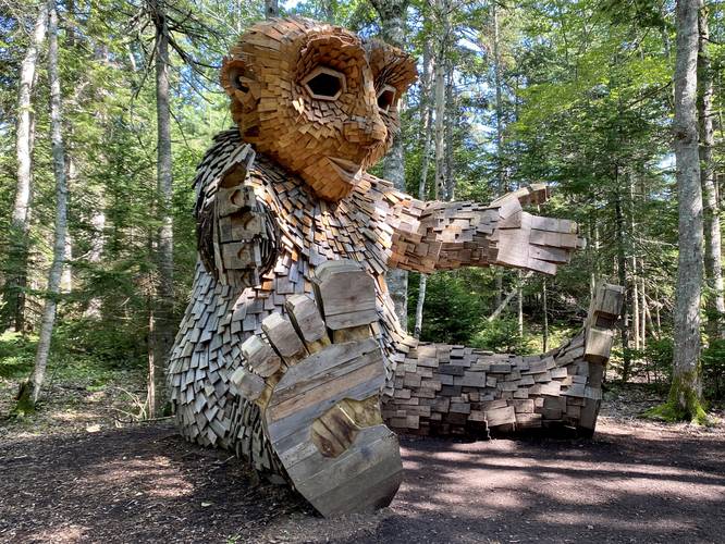
Søren (Troll) - Mile 0.7
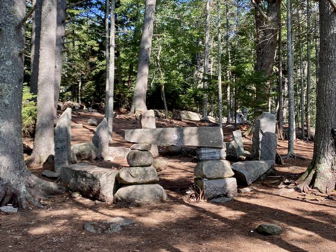
At mile 0.7, hikers will find the 3rd wood troll, Søren, located right on-trail. Søren's position is supposedly a dance, but he's likely the 2nd-largest troll in these woods.
After visiting Søren, hikers will head north once more to look for signage for "Gro", which leads to the 4th wood troll. Note that the next section of hiking requires a bit of elevation gain, however, it's not very steep or long.
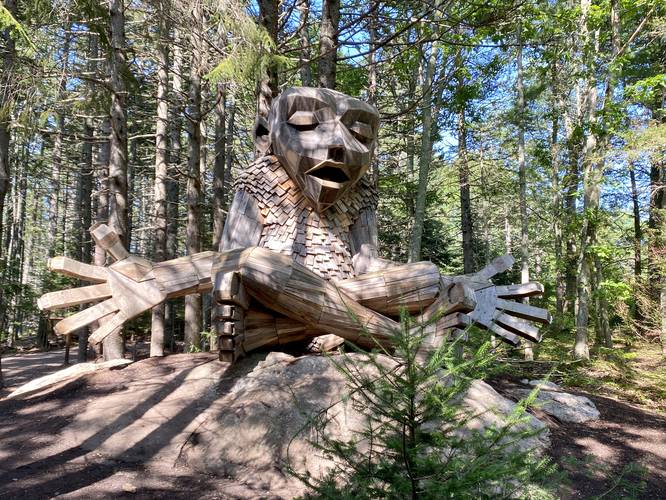
Gro (Troll) - Mile 0.85
At mile 0.85, hikers will reach Gro, the 4th wood troll in these woods. Gro sits on bedrock with her arms extended outward, as if meditating.
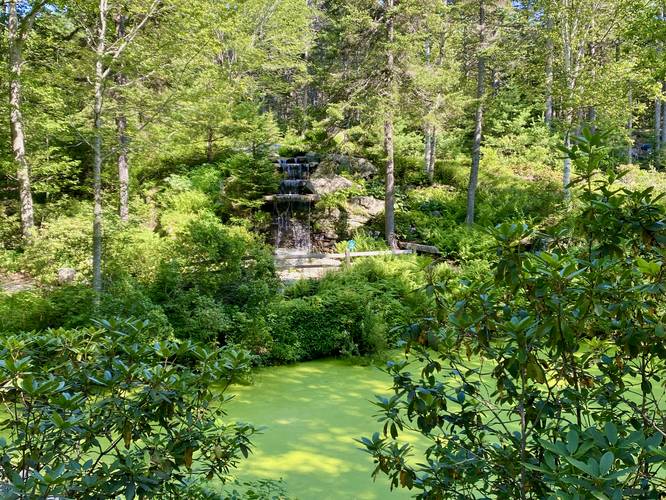
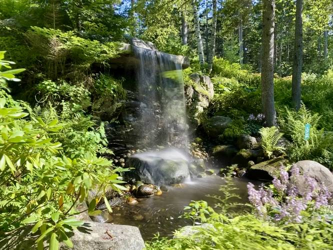
Waterfall (8-feet tall), Vibrant-Green Swamp - Mile 0.95
After visiting Gro, hikers may want to explore the swamp and waterfall area located to the east, just down the hill from Gro. Be warned, it can be buggy, but the vibrant-green swamp along with the cascading waterfall is a really nice way to change up the scenery along this hike.
Back River View - Mile 1.3
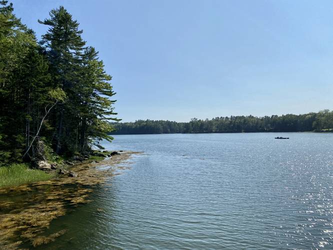
After visiting Gro and the Waterfall, hikers will head back to the main trail to head south for ~100-feet or so before taking a right-hand turn onto the Landing Trail. Hike down the Landing Trail to find an off-shoot dock that juts over Back River. The dock provides views of Back River, which is another nice way to change up the scenery from the forest walk. After this you'll hike south along the Shoreland Trail.
Fairy House Village - Mile 1.4
At mile 1.4, hikers will find a Fairy House Village built up with tiny sticks, doo-dads, and other things that fairies clearly like to build structures with.
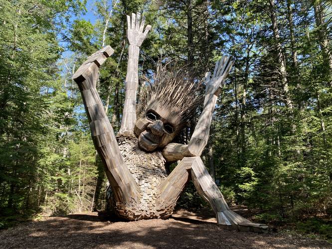
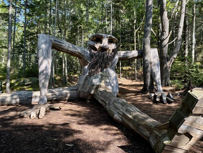
Birk (Troll) - Mile 1.5
At mile 1.5, along the Shoreland Trail, hikers will find the 5th and last wood troll along the hike, named Birk. Birk is clearly the eldest wood troll as displayed by his large beard. He's also the largest wood troll by width, not height.
Hiking Out via Stunning Gardens - Mile 1.5 to 2.3
After visiting Birk, the troll exploration of the hike is over, but there are still plenty of beautiful gardens to walk through and enjoy as you meander out of the botanical gardens. This track heads up the Haney Hillside Garden trail, visits Cleaver Lawn and Slater Forest Pond before passing through Lerner Garden of the Five Senses which includes more water features and a human-made waterfall. Finally, the track heads back to the Native Butterfly House and Gardens before passing over the wetland swamps to then exit the gardens.
Fees
As of July 2023, there's a $25/person entrance fee. Membership holders can get-in for free and membership passes are tied to a network of botanic gardens across the Northeast US, so if you enjoy botanic gardens, it's worth considering an annual pass.
Parking
Hikers will find massive parking lots at the coordinates provided. The lots are large enough to fit many dozens of vehicles.
Pets
Dogs are not allowed unless they are a service animal.
Hike Description
This hike begins at the main entrance building and follows the boardwalk over wetlands to reach the native butterfly house and gardens. Here, stay right to head north toward the first troll, Roskva.
Roskva (Troll) - Mile 0.2
At mile 0.2, hikers will reach the first wood troll, named Roskva. This troll is one of the tallest, if not the tallest, along the walk.
After visiting Roskva, this hike leads to the restaurant pavilion and then skirts around the building to the north to head east once again. When you reach another wide dirt trail junction, take the left-hand turn onto Birch Allee to head toward the next troll, Lilja.
Lilja (Troll) - Mile 0.45
Around mile 0.45, after taking a left-hand turn at the Lilja sign, hikers will reach the 2nd wood troll on the hike, named Lilja. Lilja is supposedly the youngest of the trolls in these woods. After visiting Lilja, head back to the main trail (Birch Allee) you just hiked off of.
Søren (Troll) - Mile 0.7
At mile 0.7, hikers will find the 3rd wood troll, Søren, located right on-trail. Søren's position is supposedly a dance, but he's likely the 2nd-largest troll in these woods.
After visiting Søren, hikers will head north once more to look for signage for "Gro", which leads to the 4th wood troll. Note that the next section of hiking requires a bit of elevation gain, however, it's not very steep or long.
Gro (Troll) - Mile 0.85
At mile 0.85, hikers will reach Gro, the 4th wood troll in these woods. Gro sits on bedrock with her arms extended outward, as if meditating.
Waterfall (8-feet tall), Vibrant-Green Swamp - Mile 0.95
After visiting Gro, hikers may want to explore the swamp and waterfall area located to the east, just down the hill from Gro. Be warned, it can be buggy, but the vibrant-green swamp along with the cascading waterfall is a really nice way to change up the scenery along this hike.
Back River View - Mile 1.3
After visiting Gro and the Waterfall, hikers will head back to the main trail to head south for ~100-feet or so before taking a right-hand turn onto the Landing Trail. Hike down the Landing Trail to find an off-shoot dock that juts over Back River. The dock provides views of Back River, which is another nice way to change up the scenery from the forest walk. After this you'll hike south along the Shoreland Trail.
Fairy House Village - Mile 1.4
At mile 1.4, hikers will find a Fairy House Village built up with tiny sticks, doo-dads, and other things that fairies clearly like to build structures with.
Birk (Troll) - Mile 1.5
At mile 1.5, along the Shoreland Trail, hikers will find the 5th and last wood troll along the hike, named Birk. Birk is clearly the eldest wood troll as displayed by his large beard. He's also the largest wood troll by width, not height.
Hiking Out via Stunning Gardens - Mile 1.5 to 2.3
After visiting Birk, the troll exploration of the hike is over, but there are still plenty of beautiful gardens to walk through and enjoy as you meander out of the botanical gardens. This track heads up the Haney Hillside Garden trail, visits Cleaver Lawn and Slater Forest Pond before passing through Lerner Garden of the Five Senses which includes more water features and a human-made waterfall. Finally, the track heads back to the Native Butterfly House and Gardens before passing over the wetland swamps to then exit the gardens.
Fees
As of July 2023, there's a $25/person entrance fee. Membership holders can get-in for free and membership passes are tied to a network of botanic gardens across the Northeast US, so if you enjoy botanic gardens, it's worth considering an annual pass.
Parking
Hikers will find massive parking lots at the coordinates provided. The lots are large enough to fit many dozens of vehicles.
Pets
Dogs are not allowed unless they are a service animal.