The Clements Pond Trail & Vista at Adirondack Park within the Wilmington Wild Forest in Keene, New York is a moderate 3.3-mile out-and-back hike that leads to the shores of Clements Pond and features an off-trail vista atop Clements Ledge.
Hike Description
This hike begins at the main parking lot for the Clements Pond Trail and Clements Mountain Tract at the coordinates provided. The trailhead is located on the north side the street; however, the trail signage is located on the south side. As of March 2023, there was a small blue ribbon that marked the trailhead - a bit harder to spot during the Winter months. Upon entering the trail, hikers will cross a small brook that spills down Clements Mountain, cross a small footbridge over the brook, and then immediately reach the trail registry kiosk. It's a good habit to sign-in, just in case something were to happen to you while out on the trail.
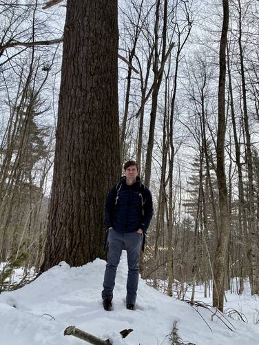
Old-Growth Eastern White Pine - Mile 0.25
Around mile 0.25, hikers will reach a very old Eastern White Pine tree. It's pretty easy to miss, likely during warmer months with leaves on the trees, but in the Winter it stuck out. I did not measure this old-growth white pine, so I will not attempt to estimate its age.
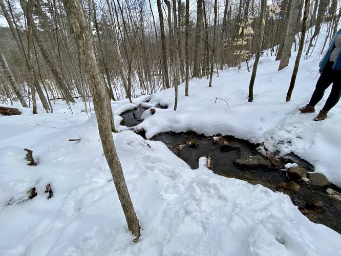
Creek Crossings - Mile 0.45 to 0.55
From miles 0.45 to 0.55 or so, there are a couple of creek crossings - nothing too deep, but something to note.
Boulder for Bouldering - Mile 0.6
At mile 0.6, hikers will reach a ~10-foot tall 20-foot wide (or more) large boulder sitting right on-trail. This boulder is a great spot for boulderers, if they're willing to lug their mats up the mountain.
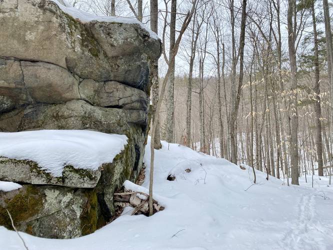
Rocky Terrain to Clements Ledge - Mile 0.8 to 0.9
Around mile 0.8, hikers will reach a more rocky terrain (even during the Winter) that leads up a switchback to Clements Ledge, which sits around mile 0.9. Clements Ledge is a ~50-foot tall rock ledge that sits off-trail. This ledge provides rock climbing opportunities for climbers and a nice off-trail (bushwhack) vista for hikers, which I document on the hike out from Clements Pond. After reaching Clements Ledge, the hike flattens out slightly as it slowly meanders its way uphill before heading right back downhill to reach the pond, around mile 1.15.
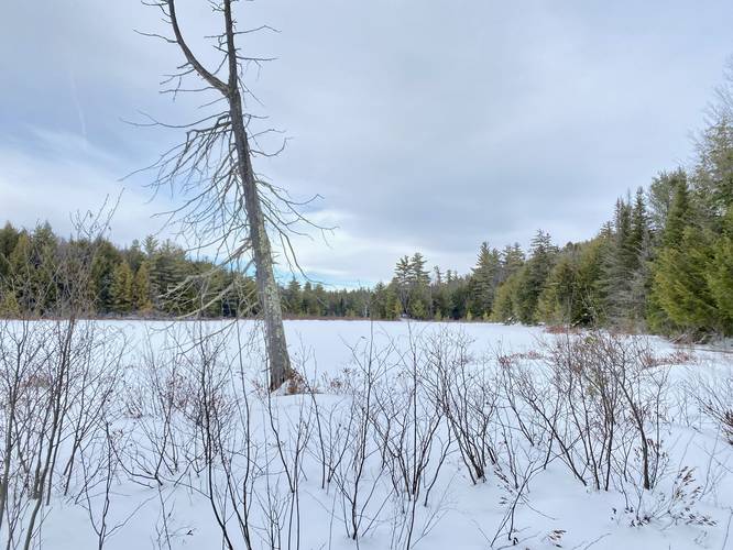
Clements Pond - Mile 1.5
The hike down to Clements Pond follows a fairly narrow trail that leads 160 vertical feet downhill along one switchback. Near the bottom of the hill, the trail technically continues to reach the northeast corner of Clements Pond, but I decided to quickly bushwhack out to Clements Pond shore to turn back at mile 1.5, albeit, it's likely much easier for hikers to reach the shore by just hiking a bit further. Clements Pond, from the southern shore, is nothing special to look at, but is surrounded by large evergreens and deciduous trees. During the Winter, it's hard to tell where the pond's water begins and during warmer days, the slushy, muddy, and wet ground near the banks can be misleading when covered in snow, so watch your step during those months. The hike back, at least uphill from Clements Pond, is not difficult, but more of a moderate hike.
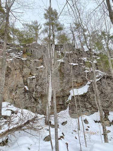
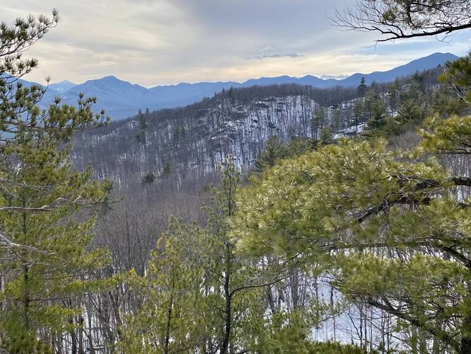
(Optional) Clements Ledge Vista - Mile 1.9 to 2.3
Around mile 1.9, on the hike out, hikers can choose to bushwhack their way to the end of Clements Ledge by going off-trail at mile 1.9. The hike off-trail is however you wish, go where ever you want - during this hike I was aiming for a different rock ledge; however, to save time I skipped back over to Clements Ledge to try for a view there and sure enough there was a nice view between the trees. Clements Ledge doesn't provided the best view, but it provides a nice one regardless. This spot seems to be pretty remote as only deer tracks and scat were found atop the ledge. Maybe during the Summer some climbers make their way up here, but other than that it's likely a very quiet unknown spot to enjoy some nice views of the Adirondack Mountains. The views mostly look into the High Peaks Wilderness area.
After visiting Clements Pond and/or Clements Ledge Vista, the hike out obviously follows the same blue blazed trail on the hike in. Watch your step around the rocky path just south of Clements Ledge (especially with regard to undermining from snow melt in the Spring or late Winter).
Parking
Hikers will find a large parking lot at the coordinates provided, large enough to fit a dozen vehicles or so. During the Winter, this lot is not plowed, as of March 2023, but hikers can usually find a small turnout in front of the parking lot.
Pets
Dogs are allowed if leashed and must be cleaned up after.
Hike Description
This hike begins at the main parking lot for the Clements Pond Trail and Clements Mountain Tract at the coordinates provided. The trailhead is located on the north side the street; however, the trail signage is located on the south side. As of March 2023, there was a small blue ribbon that marked the trailhead - a bit harder to spot during the Winter months. Upon entering the trail, hikers will cross a small brook that spills down Clements Mountain, cross a small footbridge over the brook, and then immediately reach the trail registry kiosk. It's a good habit to sign-in, just in case something were to happen to you while out on the trail.
Old-Growth Eastern White Pine - Mile 0.25
Around mile 0.25, hikers will reach a very old Eastern White Pine tree. It's pretty easy to miss, likely during warmer months with leaves on the trees, but in the Winter it stuck out. I did not measure this old-growth white pine, so I will not attempt to estimate its age.
Creek Crossings - Mile 0.45 to 0.55
From miles 0.45 to 0.55 or so, there are a couple of creek crossings - nothing too deep, but something to note.
Boulder for Bouldering - Mile 0.6
At mile 0.6, hikers will reach a ~10-foot tall 20-foot wide (or more) large boulder sitting right on-trail. This boulder is a great spot for boulderers, if they're willing to lug their mats up the mountain.
Rocky Terrain to Clements Ledge - Mile 0.8 to 0.9
Around mile 0.8, hikers will reach a more rocky terrain (even during the Winter) that leads up a switchback to Clements Ledge, which sits around mile 0.9. Clements Ledge is a ~50-foot tall rock ledge that sits off-trail. This ledge provides rock climbing opportunities for climbers and a nice off-trail (bushwhack) vista for hikers, which I document on the hike out from Clements Pond. After reaching Clements Ledge, the hike flattens out slightly as it slowly meanders its way uphill before heading right back downhill to reach the pond, around mile 1.15.
Clements Pond - Mile 1.5
The hike down to Clements Pond follows a fairly narrow trail that leads 160 vertical feet downhill along one switchback. Near the bottom of the hill, the trail technically continues to reach the northeast corner of Clements Pond, but I decided to quickly bushwhack out to Clements Pond shore to turn back at mile 1.5, albeit, it's likely much easier for hikers to reach the shore by just hiking a bit further. Clements Pond, from the southern shore, is nothing special to look at, but is surrounded by large evergreens and deciduous trees. During the Winter, it's hard to tell where the pond's water begins and during warmer days, the slushy, muddy, and wet ground near the banks can be misleading when covered in snow, so watch your step during those months. The hike back, at least uphill from Clements Pond, is not difficult, but more of a moderate hike.
(Optional) Clements Ledge Vista - Mile 1.9 to 2.3
Around mile 1.9, on the hike out, hikers can choose to bushwhack their way to the end of Clements Ledge by going off-trail at mile 1.9. The hike off-trail is however you wish, go where ever you want - during this hike I was aiming for a different rock ledge; however, to save time I skipped back over to Clements Ledge to try for a view there and sure enough there was a nice view between the trees. Clements Ledge doesn't provided the best view, but it provides a nice one regardless. This spot seems to be pretty remote as only deer tracks and scat were found atop the ledge. Maybe during the Summer some climbers make their way up here, but other than that it's likely a very quiet unknown spot to enjoy some nice views of the Adirondack Mountains. The views mostly look into the High Peaks Wilderness area.
After visiting Clements Pond and/or Clements Ledge Vista, the hike out obviously follows the same blue blazed trail on the hike in. Watch your step around the rocky path just south of Clements Ledge (especially with regard to undermining from snow melt in the Spring or late Winter).
Parking
Hikers will find a large parking lot at the coordinates provided, large enough to fit a dozen vehicles or so. During the Winter, this lot is not plowed, as of March 2023, but hikers can usually find a small turnout in front of the parking lot.
Pets
Dogs are allowed if leashed and must be cleaned up after.