Loading...

❄️ WINTER SALE! 50% OFF on Supporter Accounts — now through January 31st. Unlock a full year of exclusive website & app perks. Learn More.

Castle in the Clouds Waterfalls Hike

Directions
Map
Pictures
Download Castle in the Clouds Waterfalls Hike GPX Data to the MyHikes Mobile App
Distance:
3.5 Miles / 5.6 km
Type:
Loop
Difficulty:
Easy
Time to Hike:
1 hour, ~45 minutes
Features:
Surface Type:
Dirt
Park:
Castle in the Clouds Conservation Area
Town:
Moultonborough, New Hampshire
Get Directions:
43.718643, -71.319029
Added:
September 03, 2025
Updated:
January 02, 2026
Guide by:
Copy Trail Link Hiking this trail? Send a friend or family member a link to this trail guide for your own safety. Hike at your own risk (disclaimer)
Loading...
Loading...
593'

Total Change
709'

Ascent
721'

Descent

Download the GPX Data for Offline Use

Supporters get exclusive access to download trail routes to the MyHikes app for offline use. Stay prepared on your adventure, even without an internet connection! Become a Supporter today to unlock this feature and hike with confidence.

Download Castle in the Clouds Waterfalls Hike GPX Data to the MyHikes Mobile App

Know Before You Go

  • The highlight of this 3.5-mile loop is the Brook Walk, featuring seven distinct waterfalls including the spectacular 50-foot Falls of Song.
  • This is an easy, well-marked hike suitable for various skill levels; plus, dogs are welcome on the trails as long as they are leashed.
  • Enjoy a complete day trip with ample free parking, restrooms, picnic areas at Shannon Pond, and seasonal food and ice cream at Cafe in the Clouds.

Castle in the Clouds Waterfalls Hike

Trail names: Shannon Pond Trail, Turtleback Mountain Trail, Connector Trail, Shannon Brook Trail, Brook Walk Trail

Location: Castle in the Clouds Conservation Area, Route 171, Moultonborough NH

Permitted uses: Hiking, Nature Study, Snowshoeing, Cross-country skiing, activities described as “Low impact” recreational use.

Prohibited uses: No Camping, No overnight use, No fires, No mountain bikes, No motorized vehicles, No horseback riding, no fishing.

Hours: Daylight hours, year round

Fees and Parking: There is no fee to park or use the trails. Parking is across the street from the trailhead and there is ample parking. There is also more parking available near Shannon Pond on Ossipee Park Road, Moultonborough NH.

Pets: Dogs are allowed on the trails and must be leashed.

Accessibility: Hikes are not wheelchair accessible.

Hiker amenities: There are information kiosks close to the entrances of the Brook Walk Trail and Shannon Pond Trail. Each kiosk has a posted map and information about the area. The Brook Walk kiosk has a history of the Brook Walk and waterfalls. There are restrooms and trash bins near the trailhead and also food at Cafe in the Clouds which is located between the Brook Walk and Shannon Pond Kiosks. Information about the Oak Ridge Interpretive Trail is posted on the side of the Shannon Pond information kiosk.

Length and Trail information: Our hike was done as a loop and was roughly 3.5 miles in length and was an easy hike. Each trail has its own colored trail blaze. The trails are well marked and easy to navigate. They are well traveled and it’s unlikely that you will not see other hikers or visitors during your hike.

The Hiking Trails at Shannon Pond are temporarily closed due to reconstruction, but visitors are welcome to stop at the dam and observe the wildlife at the pond and feed the trout. Shannon Pond is a man made pond that was installed around 1913 by then owner, Tom Plant. He stocked this pond with trout and had it for his personal use. This pond is still stocked with fish and visitors are encouraged to purchase food to feed the fish in the pond. Please do not bring any outside fish food to feed them. Fishing is not allowed here. There are picnic tables at the Pond, so visitors can also enjoy a picnic before or after enjoying the hiking trails. And if you time your hike just right, you might be able to get an ice cream treat from the Cafe in the Clouds.

Pond Trail runs beside Shannon Pond and looks very much like a dirt road. It provides access to the Shannon Pond Kiosk and the Turtleback Mountain Trail, Connector Trail, Brook Walk Trail, and Shannon Brook Trail. There is also an interpretive trail close by: the Oak Ridge Interpretive Trail. This trail has 18 information stops and plaques posted to assist visitors in learning about the trails and the inhabitants both past and present in this special area. Five of the 18 stops are along the Turtleback Mountain Trail, and we enjoyed stopping to read and learn about each place. This sampling of the interpretive trail was an interesting addition to our waterfall filled hike and we would encourage others to enjoy them as well.

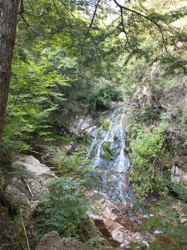
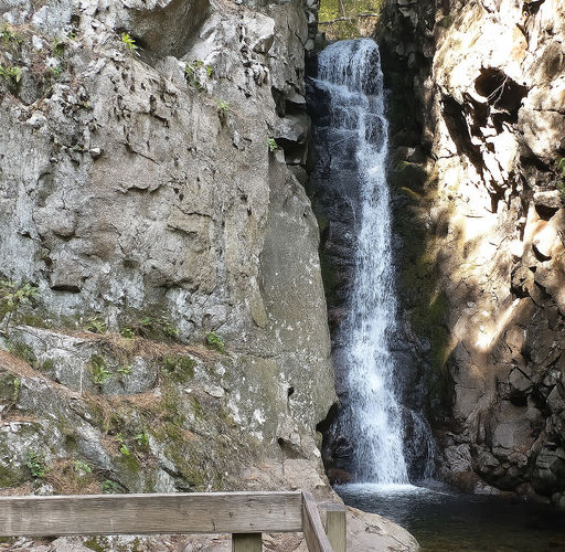
Brook Walk Trail is the highlight of this hike, but does have some very steep sections, especially coming off of the Shannon Brook trail access. If you hike Brook Walk Trail from the Shannon Brook Trail, like we did, you will be seeing the falls in reverse order. Be careful and take your time as you descend this steep section of trail as the footing can be tricky. The Brook Walk has a sturdy wooden bridge that crosses the stream and runs alongside it leading hikers to the Falls of Song Waterfall. This is the 7th waterfall on the hike and is 50 feet tall. It is considered to be the most spectacular of the series. Each of the additional six waterfalls are identified with a plaque that gives visitors insight into interesting facts about each one and offers a peek into the history associated with each waterfall. Use caution as you walk along the trail as the spray from the waterfalls can make some areas slippery. The terrain is not difficult or steep, but do use caution as there are rocks and roots to navigate, and likely your attention will be toward the beautiful waterfalls that are there and not your foot placement.

Explore 17 trails near Moultonborough, NH
  1. Parking

    43.718643, -71.319029
  2. Main Trailhead

    43.718817, -71.318983
  3. Bridal Veil Falls

    43.726626, -71.317443
    Bridal Veil Falls
  4. Falls of Song waterfall

    43.726021, -71.317408
    Falls of Song waterfall
No community routes found. To add your own hike as a Community Route for this Trail guide, leave a Trip Report with an attached GPX file.

Hazards

Ticks - Lyme Disease More Info (CDC)
Snakes
Poison Ivy/Oak
Rockfalls / Ledges / or Scrambles

Seasons

All

Trip Reports (Reviews)

Ready to help fellow hikers? Add a trip report to share your experience and provide valuable insights for those planning their next hike. Your review makes the trail better for everyone.

Your opinion matters! Be the first to rate this trail.

Weather Forecast

In Moultonborough, NH

Explore Hiking Trails

You May Also Like

Colorado's Million Dollar Highway - Plan a day's drive adventure along the iconic Million Dollar Highway in Colorado. Explore the best short trails, roadside stops, waterfalls, vistas, ghost towns, and hot springs within a ~6 hour road trip.
Explore

Colorado's Million Dollar Highway

Plan a day's drive adventure along the iconic Million Dollar Highway in Colorado. Explore the best short trails, roadside stops, waterfalls, vistas, ghost towns, and hot springs within a ~6 hour road trip.

Read
Glacier's Going-to-the-Sun Road - Discover the breathtaking beauty of Glacier National Park along the iconic Going-to-the-Sun Road. From stunning roadside stops to picturesque waterfalls and vistas, this engineering marvel offers endless opportunities for exploration.
Explore

Glacier's Going-to-the-Sun Road

Discover the breathtaking beauty of Glacier National Park along the iconic Going-to-the-Sun Road. From stunning roadside stops to picturesque waterfalls and vistas, this engineering marvel offers endless opportunities for exploration.

Read

Before you boogie...

Find our trail guides useful? Consider becoming a Supporter to unlock perks!

MyHikes is an indie platform that makes exploring public trails easier for everyone. The platform has no investors, no ads, and is owned and operated by one person, Dave Miller. Dave has personally mapped and written over 1,900 trail guides on MyHikes for the public to explore. MyHikes has helped millions outdoor enthusiasts plan their next adventure.

But it takes a lot of time 🕦, money 💰, work, and espresso shots ☕ to run MyHikes, including hiking , mapping , writing , and publishing new trails with high-quality (accurate) information... along with software engineering (coding) the platform like building new features, website and mobile app development (iOS and Android), site maintainance . and much much more.

Supporters unlock website and mobile app perks with an annual one-time payment of $25 (you renew) 😎👍. Or you can simply make a Donation of your choice. Otherwise, you can support us by telling your friends about MyHikes - both quick and free 🎉

Admin avatar

Dave Miller
MyHikes Founder
🍪 We use cookies to learn about site usage, performance, and to serve map tiles. You may block cookies manually in the browser. By continuing to use MyHikes, you agree. Learn more