Campbell's Ledge near Duryea, Pennsylvania is a moderate 3-mile out-and-back hike that leads through the woods of an old coal mine to reach a beautiful view of the Susquehanna River at the top of a mountain from a rock ledge known as Campbell's Ledge.
Trails
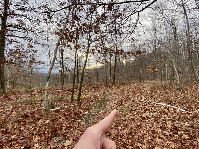
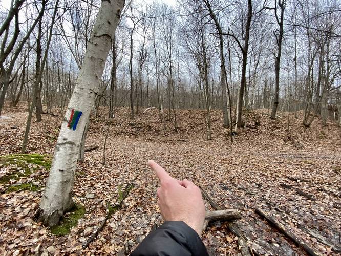
This hike follows a service road and several unnamed trails. These unnamed trails are marked with multi-colored blazes - green, blue, and red used in combination as a "blaze"; however, sometimes these tri-colored blazes only include one or two colors. Due to the lack of standardized blazes, it's best to use an offline mapping tool to aid in navigating these woods.
Hike Description
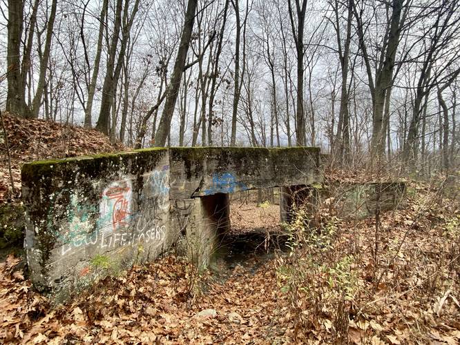
This hike begins at the parking coordinates provided, at the 90-degree bend in Coxton Rd and follows the service road as it heads uphill and into the woods. Note that there's a gate with signs labeled "private property" on the right-hand side, do not enter that gate but rather the State Game Lands gate. This service road leads up to a water tower on the side of the mountain, but along the way, hikers will pass an old abandoned road bridge that sits off-trail.
Left-Hand Bend and Left-Hand Turn - Mile 0.33
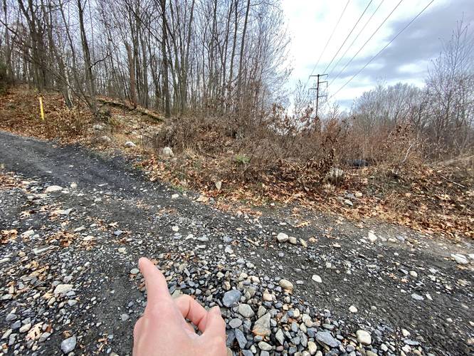
At mile 0.33, there's a large bend in the road that heads left (heading northward). Take this bend in the service road and then look for another left-hand trail junction about 100-feet up the road.
Stay Left - Mile 0.55
At mile 0.55, stay left to head toward the Moosic Valley Vista.
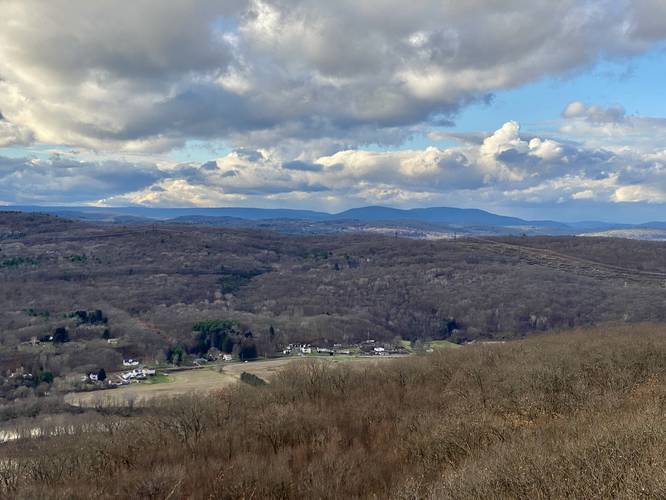
Moosic Valley Vista - Mile 0.6
Around mile 0.6, hikers will spot a large rocky outcropping located just off-trail, this is the Moosic Valley Vista. Here, hikers can head off-trail for a short distance to get a view of the Moosic Valley with Duryea, Moosic, and Dupont, Pennsylvania sitting in the valley below.
Quarry Piles / Tailings & Overlook - Mile 0.75
Around mile 0.7, hikers will enter an area that was once used to dump quarry tailings (leftover rocks/dirt, etc.) and just beyond these large pyramid-shaped mounts of rock lies a quarry overlook that sits about 60-feet above the floor of the quarry. This is an interesting spot to check out because the mining companies of the past once carved out this entire section of mountain to resell on the market - leaving behind a 60-foot deep pit.
Right-Hand Turn - Mile 0.85
Around mile 0.85, take a right-hand turn.
Left-Hand Turn - Mile 0.95
Around mile 0.95, take a left-hand turn.
Abandoned Coal Mine #1 - Mile 1
At mile 1, hikers will find a broken fence that encompasses a large pit in the ground - this pit is an old abandoned coal mine entrance or potentially an old mine draft (used for exchanging air or hauling out goods). By the looks of it, this may have been a mine draft. Do not enter the mine and stay out of the pits!
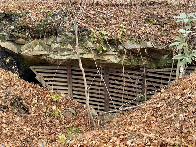
Abandoned Coal Mine #2 - Mile 1.1
Just up the trail is yet another abandoned coal mine entrance or mine draft. This area is surrounded by a broken fence as of November, 2022. Do not enter the mine and stay out of the pits! One interesting thing to note about these mine drafts is the warm air that escapes from beneath the mountain, during cold months. Hikers may notice an abundance of ferns and moss growing around the entrance as these mine drafts provide a wet and temperate climate.
Left-hand Turn - Mile 1.25
After passing the mine entrances / drafts, hikers will head up the mountain for a short while before reaching the service road once again. Take a left-hand turn to head up the mountain to reach Campbell's Ledge.
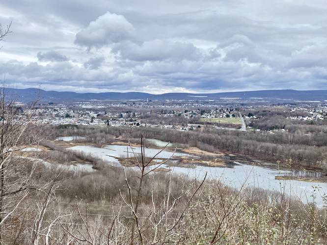
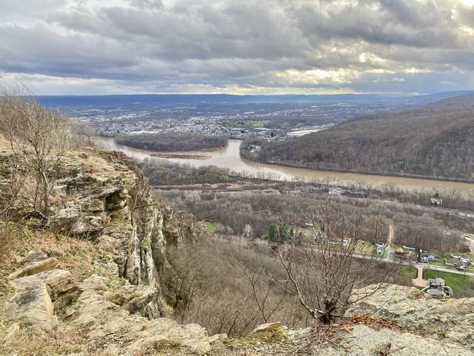
Campbell's Ledge - Mile 1.4 to 1.5
Finally, hikers will reach the summit of the mountain, where they'll find Campbell's Ledge situated on the southern slope. The view from Campbell's Ledge provides a sweeping vista of the Susquehanna River, neighboring mountains, and peers into the Wilkes-Barre valley. Hikers can walk the ledge for about 0.1-miles west to get different vantage points of the view, Campbell's Ledge, or the surrounding mountains.
Hiking Out
While hiking out is not difficult, you need to pay attention to each turn that you took on the way in to ensure you don't get lost on the hike out.
Warnings
Private property: Note that this hike passes through private property that allows hunters and hikers. At the entrance gate are signs for the Pennsylvania State Game Commission for state game lands; however, this property is not technically state game lands - it's still owned by a corporation that owns the coal mines on the mountain. Please stay out of any "private" marked areas - located with signs or large purple blazes on trees. Despite these woods allowing public hiking and hunting access, there are section where the land owners do not want people going - these areas are fenced off, posted with signs, or posted with purple blaze markers that define boundaries. It's best to stay on-trail at all times.
Mine entrances / Ledge Drop-offs: This hike passes through an old coal mine where at one point both surface mining and underground mining took place. Due to this, massive chunks of land were carved out, leaving large cliffs and drop-offs in the forest where surface mining stripped the land - now leaving large quarries behind. Other places, as seen in the POI, have literal underground mine entrances that are fenced-off to prevent people or animals from entering. Hike at your own risk.
Trails
This hike follows a service road and several unnamed trails. These unnamed trails are marked with multi-colored blazes - green, blue, and red used in combination as a "blaze"; however, sometimes these tri-colored blazes only include one or two colors. Due to the lack of standardized blazes, it's best to use an offline mapping tool to aid in navigating these woods.
Hike Description
This hike begins at the parking coordinates provided, at the 90-degree bend in Coxton Rd and follows the service road as it heads uphill and into the woods. Note that there's a gate with signs labeled "private property" on the right-hand side, do not enter that gate but rather the State Game Lands gate. This service road leads up to a water tower on the side of the mountain, but along the way, hikers will pass an old abandoned road bridge that sits off-trail.
Left-Hand Bend and Left-Hand Turn - Mile 0.33
At mile 0.33, there's a large bend in the road that heads left (heading northward). Take this bend in the service road and then look for another left-hand trail junction about 100-feet up the road.
Stay Left - Mile 0.55
At mile 0.55, stay left to head toward the Moosic Valley Vista.
Moosic Valley Vista - Mile 0.6
Around mile 0.6, hikers will spot a large rocky outcropping located just off-trail, this is the Moosic Valley Vista. Here, hikers can head off-trail for a short distance to get a view of the Moosic Valley with Duryea, Moosic, and Dupont, Pennsylvania sitting in the valley below.
Quarry Piles / Tailings & Overlook - Mile 0.75
Around mile 0.7, hikers will enter an area that was once used to dump quarry tailings (leftover rocks/dirt, etc.) and just beyond these large pyramid-shaped mounts of rock lies a quarry overlook that sits about 60-feet above the floor of the quarry. This is an interesting spot to check out because the mining companies of the past once carved out this entire section of mountain to resell on the market - leaving behind a 60-foot deep pit.
Right-Hand Turn - Mile 0.85
Around mile 0.85, take a right-hand turn.
Left-Hand Turn - Mile 0.95
Around mile 0.95, take a left-hand turn.
Abandoned Coal Mine #1 - Mile 1
At mile 1, hikers will find a broken fence that encompasses a large pit in the ground - this pit is an old abandoned coal mine entrance or potentially an old mine draft (used for exchanging air or hauling out goods). By the looks of it, this may have been a mine draft. Do not enter the mine and stay out of the pits!
Abandoned Coal Mine #2 - Mile 1.1
Just up the trail is yet another abandoned coal mine entrance or mine draft. This area is surrounded by a broken fence as of November, 2022. Do not enter the mine and stay out of the pits! One interesting thing to note about these mine drafts is the warm air that escapes from beneath the mountain, during cold months. Hikers may notice an abundance of ferns and moss growing around the entrance as these mine drafts provide a wet and temperate climate.
Left-hand Turn - Mile 1.25
After passing the mine entrances / drafts, hikers will head up the mountain for a short while before reaching the service road once again. Take a left-hand turn to head up the mountain to reach Campbell's Ledge.
Campbell's Ledge - Mile 1.4 to 1.5
Finally, hikers will reach the summit of the mountain, where they'll find Campbell's Ledge situated on the southern slope. The view from Campbell's Ledge provides a sweeping vista of the Susquehanna River, neighboring mountains, and peers into the Wilkes-Barre valley. Hikers can walk the ledge for about 0.1-miles west to get different vantage points of the view, Campbell's Ledge, or the surrounding mountains.
Hiking Out
While hiking out is not difficult, you need to pay attention to each turn that you took on the way in to ensure you don't get lost on the hike out.
Warnings
Private property: Note that this hike passes through private property that allows hunters and hikers. At the entrance gate are signs for the Pennsylvania State Game Commission for state game lands; however, this property is not technically state game lands - it's still owned by a corporation that owns the coal mines on the mountain. Please stay out of any "private" marked areas - located with signs or large purple blazes on trees. Despite these woods allowing public hiking and hunting access, there are section where the land owners do not want people going - these areas are fenced off, posted with signs, or posted with purple blaze markers that define boundaries. It's best to stay on-trail at all times.
Mine entrances / Ledge Drop-offs: This hike passes through an old coal mine where at one point both surface mining and underground mining took place. Due to this, massive chunks of land were carved out, leaving large cliffs and drop-offs in the forest where surface mining stripped the land - now leaving large quarries behind. Other places, as seen in the POI, have literal underground mine entrances that are fenced-off to prevent people or animals from entering. Hike at your own risk.