Loading...

❄️ WINTER SALE! 50% OFF on Supporter Accounts — now through January 31st. Unlock a full year of exclusive website & app perks. Learn More.

Buena Vista Park Summit Trail

The Summit Trail at Buena Vista Park in San Francisco, California is a moderate to difficult 0.9 mile out-and-back hike up to the top of the park's summit. The trail is fairly steep all the way to the top, but the main trail is also paved.

This recording starts at staircase next to the intersection of Haight and Baker St and follows the widest paved trail, staying left at most trail junctions to reach the summit. There are various ways you can reach the top and descent from it, but this track is more of an out-and-back hike that ends along Haight St and Buena Vista Ave West.

For a slightly easier hike up to the summit, you can hop on a trail near the intersection of Buena Vista Ave East and Upper Terrace Rd since the elevation at that trailhead is closer to the summit, but there's still some hill to climb.

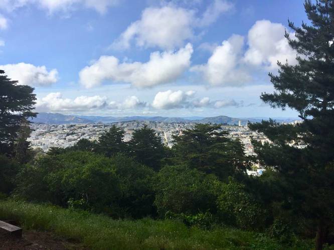
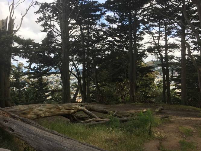
Lookout Points: The easiest lookout point can be found at the top of the park. Just northeast of the summit, if you head back down the staircase, is a dirt trail that leads downhill, but gives more views of the surrounding area. The dirt trail eventually leads back to the main paved trail.

Staircases: there are various staircases along this trail to the top of the park. There is a wheelchair accessible way to get to the top, but this recording is not that way - both trailheads (beginning and end of this recording) have stairs and lead to more stairs.

Dogs are allowed, but biking is not.
Explore 30 trails near San Francisco, CA

Know Before You Go

  • The Summit Trail in Buena Vista Park is a 0.9-mile paved out-and-back hike considered moderate to difficult due to its steep incline.
  • The trail starts near Haight and Baker St, leading to the park's summit with an option for a slightly easier route starting near Buena Vista Ave East and Upper Terrace Rd.
  • The trail features lookout points near the summit, staircases, and allows dogs, but prohibits biking.
Interactive topographic map for Buena Vista Park Summit Trail located in San Francisco, CA. Click the "View Map" button to load GPS coordinates and trail markers.
Get directions
Distance
0.9 mi
Difficulty
Hard
Type
Out-and-Back
Est. Time
27 min
Elev. Gain
262'
Rating
0.0
Added
May 15, 2018
Updated
January 23, 2020

Weather Forecast

Loading...
Total Change
269'
Ascent
262'
Descent
251'
Loading...

Download the GPX Data for Offline Use

Supporters get exclusive access to download trail routes to the MyHikes app for offline use. Stay prepared on your adventure, even without an internet connection! Become a Supporter today to unlock this feature and hike with confidence.

Download Buena Vista Park Summit Trail GPX Data to the MyHikes Mobile App

Features

Vista / Lookout Point
Dogs

Points of interest

  1. Parking

    37.770773, -122.441026
  2. Main Trailhead

    37.770737, -122.440617
  3. View from the summit of the park

    37.767922, -122.441497
    View from the summit of the park
  4. View of downtown San Francisco

    37.769528, -122.440011
    View of downtown San Francisco

Safety information

For your own safety: plan ahead, let someone know where you'll be, and hike at your own risk.

Availability

All seasons

Surface type

Paved

Trip Reports (Reviews)

Your opinion matters! Be the first to rate this trail.

Ready to help fellow hikers? Add a trip report to share your experience and provide valuable insights for other hikers!

No community routes found. To add your own hike as a Community Route for this Trail guide, leave a Trip Report with an attached GPX file.

Popular categories

Scenic mountain view representing vista trails
Vista trails
Scenic gorge of cascades representing waterfall trails
Waterfall hikes
Rugged mountain terrain representing summit trails
Summit trails
Scenic mountain view representing dog-friendly trails
Dog-friendly
Scenic campsite with a view representing camping trails
Camping trails
Appalachian Trail logo representing A.T. hikes
A.T. hikes

You May Also Like

Colorado's Million Dollar Highway - Plan a day's drive adventure along the iconic Million Dollar Highway in Colorado. Explore the best short trails, roadside stops, waterfalls, vistas, ghost towns, and hot springs within a ~6 hour road trip.
Explore

Colorado's Million Dollar Highway

Plan a day's drive adventure along the iconic Million Dollar Highway in Colorado. Explore the best short trails, roadside stops, waterfalls, vistas, ghost towns, and hot springs within a ~6 hour road trip.

Read
Glacier's Going-to-the-Sun Road - Discover the breathtaking beauty of Glacier National Park along the iconic Going-to-the-Sun Road. From stunning roadside stops to picturesque waterfalls and vistas, this engineering marvel offers endless opportunities for exploration.
Explore

Glacier's Going-to-the-Sun Road

Discover the breathtaking beauty of Glacier National Park along the iconic Going-to-the-Sun Road. From stunning roadside stops to picturesque waterfalls and vistas, this engineering marvel offers endless opportunities for exploration.

Read
🍪 We use cookies to learn about site usage and to serve map tiles. You may block cookies manually in the browser. By continuing you agree. Learn more