The Bruce
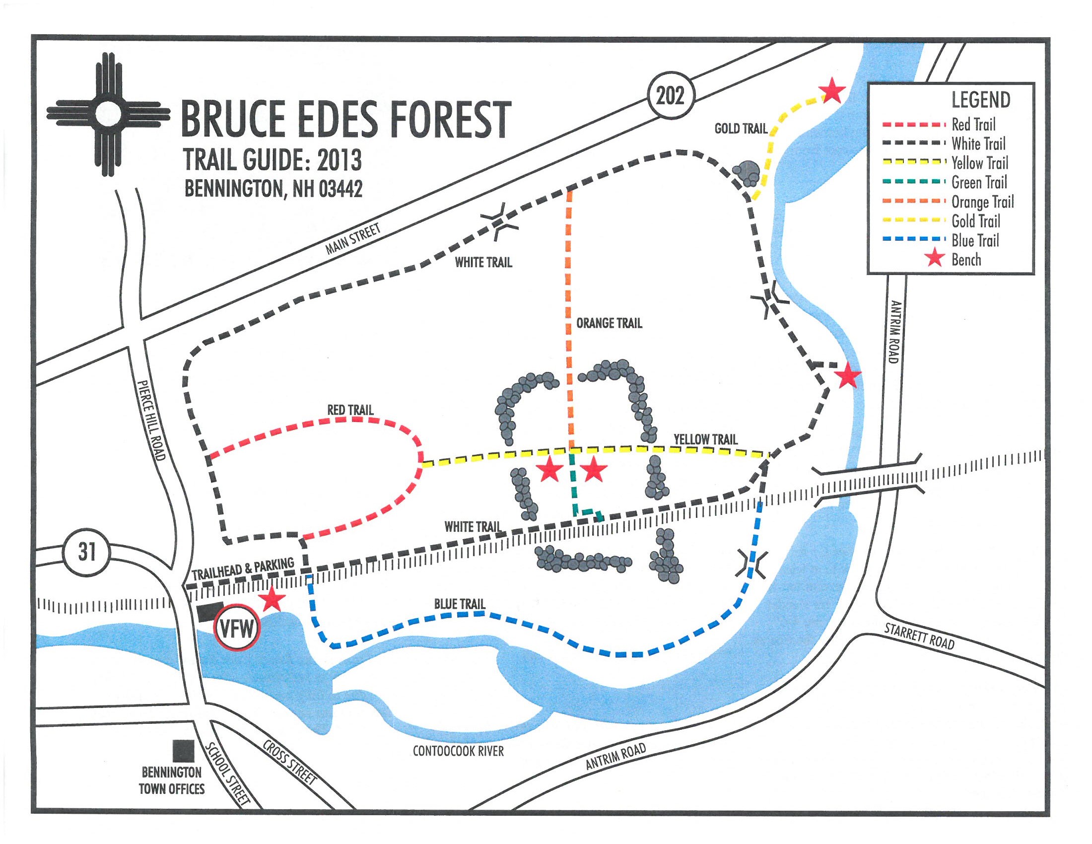
Edes Forest Trails at the Bruce Edes Memorial Forest in Bennington, New Hampshire is an easy 2.2-mile loop hike that covers all of the trails in the park.
Location: The Bruce Edes Forest Trails are located in the Monadnock region of New Hampshire, in the town of Bennington.
Trail name(s): The
trails in this forest are named by color: red, white, yellow, and green, orange,
gold and blue. This recording covers all of the trails in a linear manner - meaning if you follow this exact route, you'll hike each trail, but also hike some of them out-and-back as well.
Allowed activities: walking, hiking, geocaching, cross-country skiing, and snowshoeing.
Hours: Trails are open daily:
Monday – Saturday 9:00am to 7:00pm
Sunday 9:00am to 5:00pm
Fees and Parking: There is no fee to park or use the trails at the Bruce Edes Memorial Forest. To access the network of trails, park in the VFW parking lot located on School Street. There is a sign posted that warns “No Unauthorized Parking”, however after checking with the Bennington Police Department, we were informed that day use Parking to access the trails is allowed. There is plenty of parking in the VFW parking lot.
Pets: Dogs are allowed on the trails as long as they are leashed and waste is carried out with the hiker.
Accessibility: The trails are not wheelchair accessible.
Sanitation: There are no restrooms or trash receptacles. Carry out all trash.
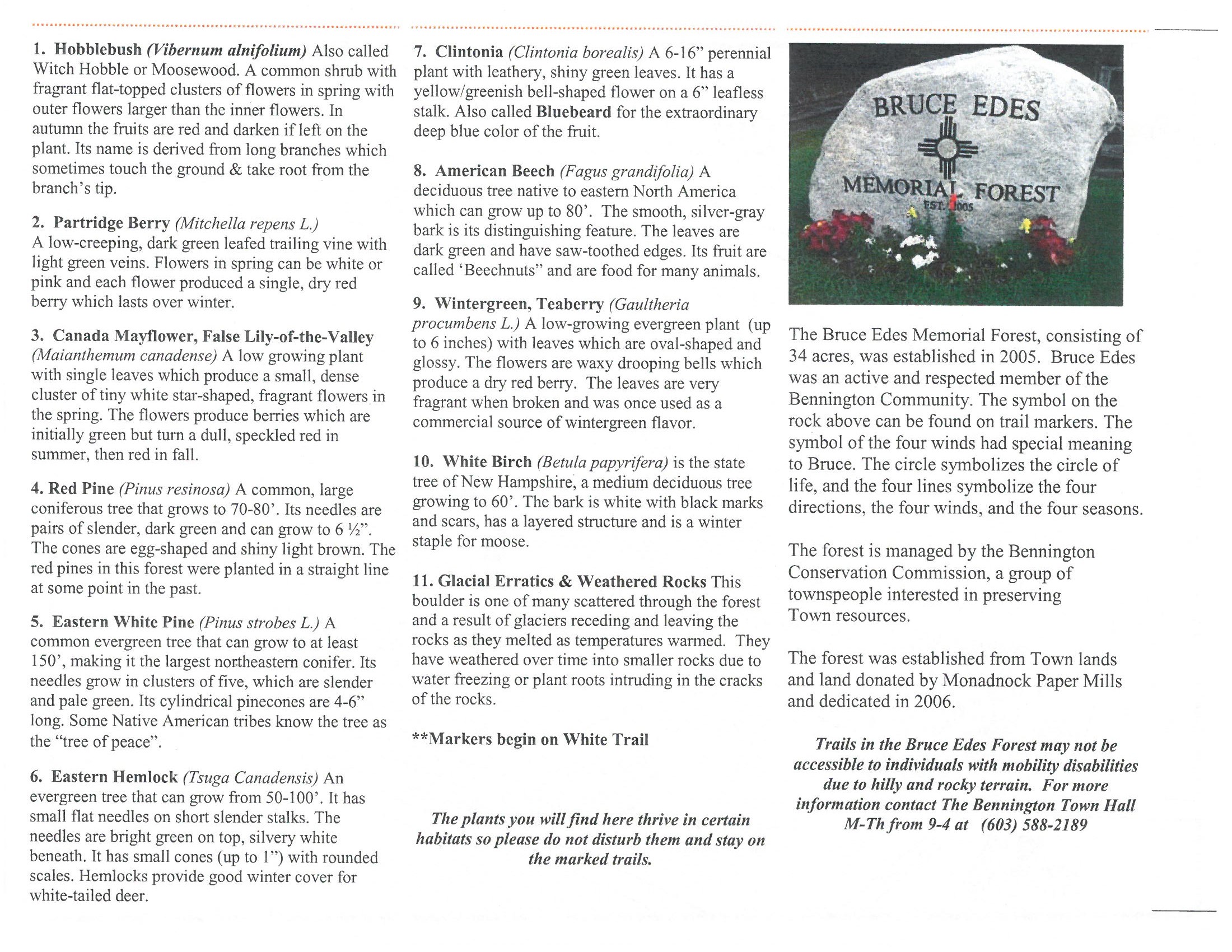
Trail information: Make sure to stop at the Trailhead board posted at the back of the VFW building and take a copy of the map. Maps are kept in a small wooden-hinged top box beside the information board. The maps have information on the back that correlate to the 11 markers that hikers will discover posted along the trails. All trails are marked with a white square trail blaze with a different colored disk in the center. The colored disc defines the trail. There is another forest sign at the Trailhead with a mailbox that contains maps and trash bags. Hikers can print a map before heading out by going to the link below or by picking up a copy from the Dodge Library or the Bennington Garage.
https://townofbennington.com/images/ms%20misc/bruce_edes_trail_map_1.jpg
Link to the 11 points of interest explained:
https://townofbennington.com/images/ms%20misc/bruce_edes_trail_map_2.jpg
Length and features: The Bruce Edes Memorial Forest in nestled between Route 202 and the Contoocook River. The 35 acres of town forest is so named to honor Mr. Bruce Edes, who was a dedicated and involved community leader. The trails in this forest are, for the most part very short. They are easily combined into a longer hike(s) with multiple loops or out and back spurs. Hikers wishing to stop to take pictures, enjoy the views, or read the 11 posted points of interest, will still be able to complete all the trails in under 2 hours. All the trails combined in this hike were an easy 2.2 miles. The hike was done as a “loop “with “out and back” spurs. There could be a number of combinations made to create longer or shorter hikes. All trails could also be done as “out and back” hikes.
To get to the network of trails, you will need to park and then
head down the railroad tracks. The trail runs parallel to the Contoocook River
and begins across the from the Pierce Power station on the opposite side of the
river. The sound of the rushing water plunging over the dam and rocks can be
quite intense. There is a bench here so visitors can relax and take in the sights
and sounds before beginning the hike. There is also a geocache hidden in this
area. The cache is a fun one to find and is well maintained.
The Blue trail
starts not too far from the bench off to the right; it descends gently and slowly
through the forest to bring visitors to the river’s edge. Large rocks in and
along the river make for some very picturesque spots. The Blue trail travels
riverside for a bit and then cuts back toward the railroad tracks where it terminates.
Across from the termination of the Blue Trail, Hikers can choose to go right or
left to continue on to the White trail. On this hike, we chose to go counter
clockwise and head back toward the beginning of the Blue Trail by taking the
White trail which runs beside the Railroad tracks, and back to the trailhead
sign. To keep on the White trail, hikers will need to go counter clockwise,
heading to the left, and up rocky hill that runs parallel to an old stone wall.
The trail will lead visitors down and around some boulders and then meander through
a forest of White pine, Eastern Hemlock, White Birch, Oak and Beech trees. The
substrate of the trail is a soft forest floor, some sections covered by a thick
carpet of pine needles. The trail is not hard to follow, and is well marked.
The trail has some rocky outcroppings, protruding roots, muddy sections and depending
on the time of your visit, the water table will vary: it may be high or low
with stream beds flowing or dry. There are several wooden bridges along the
trails that assist hikers in getting over some of the wetter sections of the
trails; other stream beds will need to be crossed carefully over moss covered
rocks.
The Gold Trail begins to the left
of the White trail, just past a very large boulder. The Gold Trail is a short “out
and back” spur that leads along the river, ending at a bench at a scenic spot; a beautiful place to rest
and take in the scenery across the river. Returning back to the White
Trail, Hikers will need to stay to the left to continue around the perimeter of
the Forest. Not too far from the
railroad tracks, the Yellow Trail junction can be seen off to the right of the
White trail.
Taking the Yellow trail will lead Hikers through the forest, to a spot
where two benches sit. This spot is the junction of three trails: The Yellow trail, the short Green Trail to the
left and the longer Orange Trail to the right. The Green trail is a shortcut to
the White trail.
The Orange trail is a bit longer and cuts through the forest
to intersect with the White trail on the opposite side of the Forest. If hikers
decide to continue on the Yellow trail, they will eventually meet the Red
Trail. Going either right or left on the Red Trail will bring a hiker back to
the White trail. The views of the Contoocook River along the Blue and Gold
Trails are a delight and hiking these easy trails are a lovely way to spend a
hot summer afternoon.


