Bierstadt Lake via Bierstadt Moraine Trail in Rocky Mountain National Park near Estes Park, Colorado is a moderate 3.4-mile out-and-back hike that leads to stunning views of the mountains from the shoreline of Bierstadt Lake.
Trails
This hike follows two trails: Bierstadt Moraine Trail (follows seldom orange blaze markers), Bierstadt Lake Loop.
Hike
This hike begins at the very-large Park & Ride lot at the coordinates provided - the trailhead for the Bierstadt Moraine Trail can be found on the far western side of the parking lot. The trail heads uphill and continues doing so for most of the hike to Bierstadt Lake; however, hikers should know that on the lower slopes of the mountain, the trail is made-up primarily of small loose rocks with some larger rocks stuck into the trail scattered between. This makes for a bit of a challenge both ascending and descending (later-on) when trying to avoid rolling your ankles. This slowed us down a bit regardless.
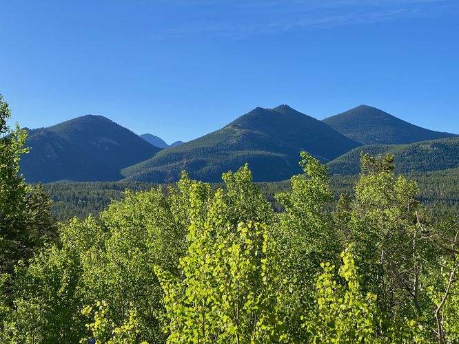
Mountain Views - Mile 0.2
Around mile 0.2, hikers will reach a view of mountains in the distance which appeared to be Lily Mountain, Estes Cone, and Twin Sisters Peaks.
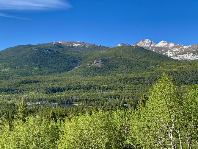
Mountain and Lake Views - Mile 0.4
At mile 0.4, hikers will reach a view from the trail that includes Sprague Lake, Battle Mountain, Storm Peak, and Longs Peak. The best part about this out-and-back is that you'll come right back to enjoy this same view on your way out as it's one of the best vistas on this trail (outside of Bierstadt Lake).
After passing the second vista, hikers will be meandering through the forest for quite a while before the next POI, which is simply the Bierstadt Lake Loop. Along the way, the forest will change from a more-sunny deciduous forest to a primarily an evergreen forest. The shade of the evergreens makes the ascent up to the lake a bit easier. The steepest section of the trail will be found between miles 0.8 to mile 1.
Bierstadt Lake Loop Junction - Mile 1.45
At mile 1.45, hikers will reach the junction with a loop trail that encompasses Bierstadt Lake. For some of the best views (west-facing), hikers can follow this track to head north along the loop -- taking a right-hand turn at the junction.
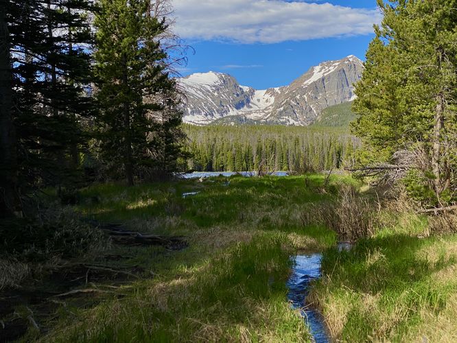
Creek & Lake View - Mile 1.55
Just off-trail at mile 1.55 is a beautiful view of Bierstadt Lake where the water flows out and down the mountain. Here, you can walk out to the creek with a nice view located just off of the main trail.
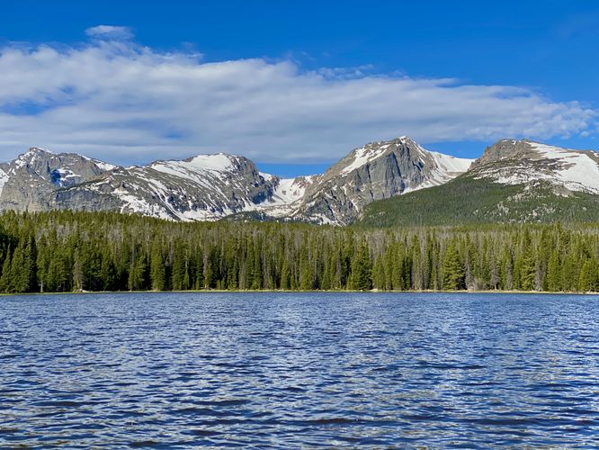
Best Bierstadt Lake Views - Mile 1.66
At mile 1.66 hikers will find another spur trail that leads to Bierstadt Lake. This is one of the best viewpoints along the entire lake. Hikers will follow this trail to the northeastern shore of Bierstadt Lake to find stunning lake and mountain views at mile 1.75. From the shore of Bierstadt Lake, hikers will find the Tyndall Glacier hanging in the high mountains along with views of Hallett Peak, Otis Peak, and Taylor Peak to name a few mountains. This shoreline is perfect for hanging out and relaxing with the breathtaking views that Bierstadt Lake has to offer. During our hike here, I made a backcountry espresso while taking-in the views before we hiked out.
Hiking Out - Mile 1.75 to 3.4
The hike out is obviously the opposite but identical hike to the way you came in. Be mindful of the turns to ensure you take the right path back to parking, watch your step on the loose rocks on-trail, and be sure to enjoy the mountain views on the hike down.
Pets
Dogs are not allowed on this trail.
Parking
Hikers will find a massive parking lot at the coordinates provided - this is the Park & Ride lot for the Bear Lake Road section of the park. The lot is large enough to fit many dozens of vehicles.
Wildlife Viewing
This trail is great for viewing wildlife, especially deer, elk, and moose due the lake's water source for drinking. If you wish to spot wildlife, your best chances are in the early morning or in the early evening. Always keep a safe distance while viewing - approx. 75-feet for elk and longhorn sheep; 120-feet for bear and moose.
Timed-Entry Reservations
Between the months of late May through early October you must purchase a timed-entry pass to visit Rocky Mountain National Park. If you wish to visitor and hike anything off of the Bear Lake Road, you must purchase a dedicated Bear Lake timed-entry pass. You can find more information about timed entry on the park's website.
Warnings
Elevation sickness: This trail brings hikers through terrain that ascends up to 9,400-feet above sea level. Around the 7,000-foot mark above sea level, hikers may start to experience symptoms of elevation sickness including headache, muscle aches, shortness of breath, among other warning signs. In order to avoid elevation sickness it's recommended to ascend to higher elevations and take short walks to acclimate over the course of several days before taking a long or physically-demanding hike. At any time you feel elevation sickness kicking in, that's the time to turn back and head for lower altitude or the parking lot.
Wild animals: While rare, hikers may encounter bears or mountain lion along the trail. Again, this is rare due to the insane amount of people who hike these trails each day; however, it's smart to know that these wild animals could be on-trail. Please read-up on how to properly handle a bear or mountain lion encounter before hitting the trails.
Trails
This hike follows two trails: Bierstadt Moraine Trail (follows seldom orange blaze markers), Bierstadt Lake Loop.
Hike
This hike begins at the very-large Park & Ride lot at the coordinates provided - the trailhead for the Bierstadt Moraine Trail can be found on the far western side of the parking lot. The trail heads uphill and continues doing so for most of the hike to Bierstadt Lake; however, hikers should know that on the lower slopes of the mountain, the trail is made-up primarily of small loose rocks with some larger rocks stuck into the trail scattered between. This makes for a bit of a challenge both ascending and descending (later-on) when trying to avoid rolling your ankles. This slowed us down a bit regardless.
Mountain Views - Mile 0.2
Around mile 0.2, hikers will reach a view of mountains in the distance which appeared to be Lily Mountain, Estes Cone, and Twin Sisters Peaks.
Mountain and Lake Views - Mile 0.4
At mile 0.4, hikers will reach a view from the trail that includes Sprague Lake, Battle Mountain, Storm Peak, and Longs Peak. The best part about this out-and-back is that you'll come right back to enjoy this same view on your way out as it's one of the best vistas on this trail (outside of Bierstadt Lake).
After passing the second vista, hikers will be meandering through the forest for quite a while before the next POI, which is simply the Bierstadt Lake Loop. Along the way, the forest will change from a more-sunny deciduous forest to a primarily an evergreen forest. The shade of the evergreens makes the ascent up to the lake a bit easier. The steepest section of the trail will be found between miles 0.8 to mile 1.
Bierstadt Lake Loop Junction - Mile 1.45
At mile 1.45, hikers will reach the junction with a loop trail that encompasses Bierstadt Lake. For some of the best views (west-facing), hikers can follow this track to head north along the loop -- taking a right-hand turn at the junction.
Creek & Lake View - Mile 1.55
Just off-trail at mile 1.55 is a beautiful view of Bierstadt Lake where the water flows out and down the mountain. Here, you can walk out to the creek with a nice view located just off of the main trail.
Best Bierstadt Lake Views - Mile 1.66
At mile 1.66 hikers will find another spur trail that leads to Bierstadt Lake. This is one of the best viewpoints along the entire lake. Hikers will follow this trail to the northeastern shore of Bierstadt Lake to find stunning lake and mountain views at mile 1.75. From the shore of Bierstadt Lake, hikers will find the Tyndall Glacier hanging in the high mountains along with views of Hallett Peak, Otis Peak, and Taylor Peak to name a few mountains. This shoreline is perfect for hanging out and relaxing with the breathtaking views that Bierstadt Lake has to offer. During our hike here, I made a backcountry espresso while taking-in the views before we hiked out.
Hiking Out - Mile 1.75 to 3.4
The hike out is obviously the opposite but identical hike to the way you came in. Be mindful of the turns to ensure you take the right path back to parking, watch your step on the loose rocks on-trail, and be sure to enjoy the mountain views on the hike down.
Pets
Dogs are not allowed on this trail.
Parking
Hikers will find a massive parking lot at the coordinates provided - this is the Park & Ride lot for the Bear Lake Road section of the park. The lot is large enough to fit many dozens of vehicles.
Wildlife Viewing
This trail is great for viewing wildlife, especially deer, elk, and moose due the lake's water source for drinking. If you wish to spot wildlife, your best chances are in the early morning or in the early evening. Always keep a safe distance while viewing - approx. 75-feet for elk and longhorn sheep; 120-feet for bear and moose.
Timed-Entry Reservations
Between the months of late May through early October you must purchase a timed-entry pass to visit Rocky Mountain National Park. If you wish to visitor and hike anything off of the Bear Lake Road, you must purchase a dedicated Bear Lake timed-entry pass. You can find more information about timed entry on the park's website.
Warnings
Elevation sickness: This trail brings hikers through terrain that ascends up to 9,400-feet above sea level. Around the 7,000-foot mark above sea level, hikers may start to experience symptoms of elevation sickness including headache, muscle aches, shortness of breath, among other warning signs. In order to avoid elevation sickness it's recommended to ascend to higher elevations and take short walks to acclimate over the course of several days before taking a long or physically-demanding hike. At any time you feel elevation sickness kicking in, that's the time to turn back and head for lower altitude or the parking lot.
Wild animals: While rare, hikers may encounter bears or mountain lion along the trail. Again, this is rare due to the insane amount of people who hike these trails each day; however, it's smart to know that these wild animals could be on-trail. Please read-up on how to properly handle a bear or mountain lion encounter before hitting the trails.