The Becket Quarry Hike at the Becket Historic Quarry & Forest in Becket, Massachusetts is an easy 1.6-mile out-and-back hike that features views of the abandoned quarry, abandoned quarry machinery, and a view of the nearby mountains from a pile of quarry rubble.
Trails
This hike follows two named trails: Entrance Trail (white blazes), Quarry Trail (black blazes).
Hike Description
This hike begins at the main parking lot and entrance to Becket Quarry and follows the white blazed Entrance Trail into the park. Along the way, hikers will pass private property and houses off to the side of the trail -- for this reason, it's best to keep your noise levels down to not disturb the neighborhood. Eventually, hikers will pass a large rockslide on the right-hand side of the trail, this means you're getting close to the Becket Quarry as these are old quarry tailings / waste rubble that was built-up to form what appears to be a huge rock slide.
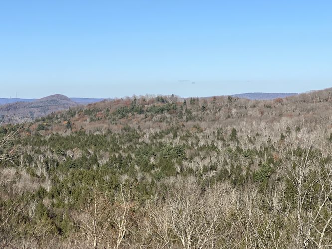
Quarry Rubble Vista - Mile 0.5
To the left-hand side of the large rock slide area is another smaller rubble pile, located around mile 0.5. Here, you can hike up the rubble to find a beautiful vista of the mountains eastward from the quarry that surround the Becket area. This view is probably one of the better reasons for hiking out, but the fun doesn't end at this view. Hike down the rubble pile to continue onward to reach the Quarry Trail and the abandoned quarry structures, equipment, and trucks.
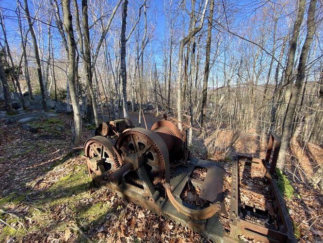
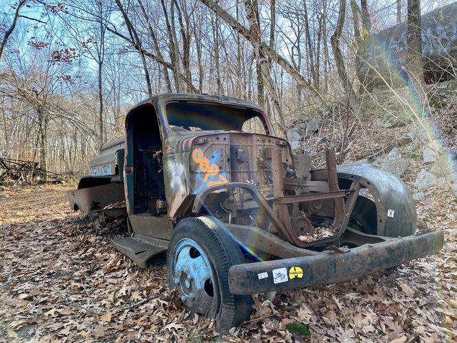
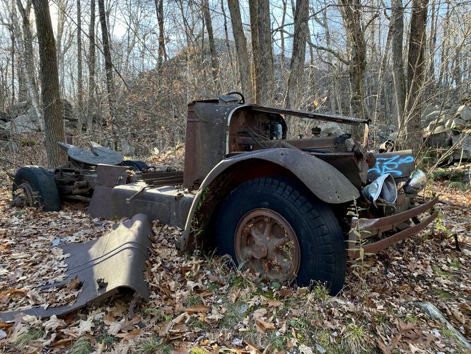
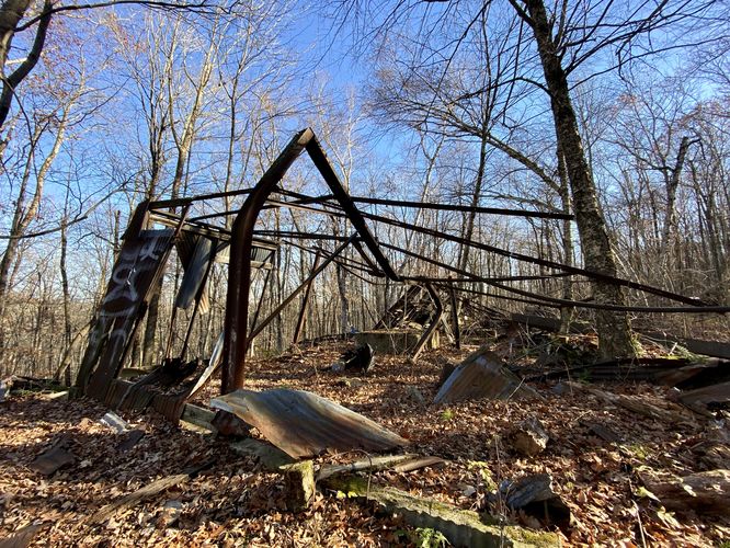
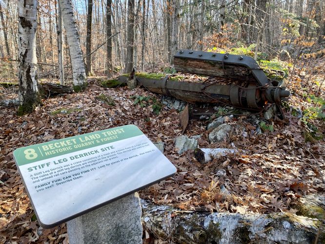
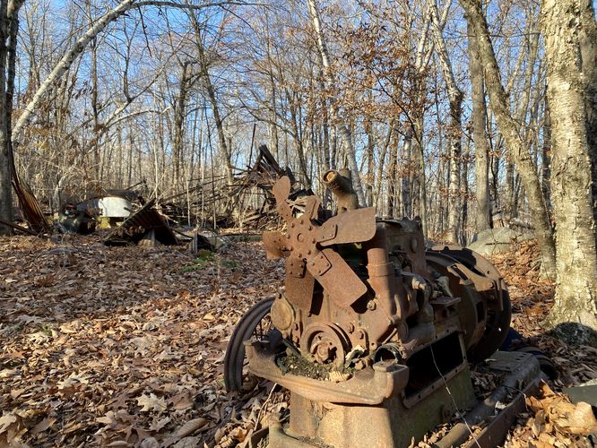
Abandoned Structures, Trucks, and Quarry Machinery - Mile 0.6 to 0.7
At mile 0.6, hikers will reach an odd-looking metal structure along the trail. This is metal structure is a long-abandoned building that once houses equipment for quarry work. The walls of the building are long-gone or have fallen down and all that remains is the skeleton. Surrounding the building are different points-of-interest like an old engine, a stiff leg derrick site, two abandoned quarry trucks, and an abandoned guy derrick. Most of the abandoned quarry equipment have interpretive signs so you can learn more about each of the devices or why the trucks existed, for example.
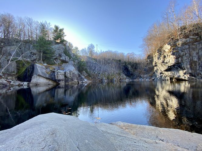
Becket Quarry and Views - Mile 0.73
Just beyond the abandoned quarry equipment lies the quiet and peaceful waters of the abandoned Becket Quarry. Hikers will find there's a ~8-foot tall rock scramble that you can take to reach the water's edge of the quarry. The trail skirts around the eastern side of the quarry, passing a rope swing, and then ends around mile 0.75 in this GPS track. Hikers can hang out, enjoy a picnic, or take a swim in the quarry if they like. It's unclear how deep the abandoned Becket Quarry is, but it must be a few dozen feet deep as the bottom was impossible to see.
Hiking out follows the same path you took in for an easy 1.6-mile out-and-back hike.
Fees
As of November 2023, there's a $10/vehicle fee for every car parking at Becket Quarry. These fees are used to help maintain the land.
Parking
Hikers will find a small parking lot at the coordinates provided in Becket, MA along Quarry Road. The lot is large enough to fit about a dozen vehicles if not slightly less.
Pets
Dogs are allowed only if leashed and must be cleaned up after.
Warning
Rusty stuff: Got your tetanus shot recently? Might want to consider it before hiking here due to the old abandoned quarry machinery. Or just don't touch or accidentally fall on the rusty stuff.
Slick quarry bedrock: If you want a better view of the quarry, you can scramble down the bedrock below; however, watch out when it's wet as this bedrock gets slippery.
Trails
This hike follows two named trails: Entrance Trail (white blazes), Quarry Trail (black blazes).
Hike Description
This hike begins at the main parking lot and entrance to Becket Quarry and follows the white blazed Entrance Trail into the park. Along the way, hikers will pass private property and houses off to the side of the trail -- for this reason, it's best to keep your noise levels down to not disturb the neighborhood. Eventually, hikers will pass a large rockslide on the right-hand side of the trail, this means you're getting close to the Becket Quarry as these are old quarry tailings / waste rubble that was built-up to form what appears to be a huge rock slide.
Quarry Rubble Vista - Mile 0.5
To the left-hand side of the large rock slide area is another smaller rubble pile, located around mile 0.5. Here, you can hike up the rubble to find a beautiful vista of the mountains eastward from the quarry that surround the Becket area. This view is probably one of the better reasons for hiking out, but the fun doesn't end at this view. Hike down the rubble pile to continue onward to reach the Quarry Trail and the abandoned quarry structures, equipment, and trucks.
Abandoned Structures, Trucks, and Quarry Machinery - Mile 0.6 to 0.7
At mile 0.6, hikers will reach an odd-looking metal structure along the trail. This is metal structure is a long-abandoned building that once houses equipment for quarry work. The walls of the building are long-gone or have fallen down and all that remains is the skeleton. Surrounding the building are different points-of-interest like an old engine, a stiff leg derrick site, two abandoned quarry trucks, and an abandoned guy derrick. Most of the abandoned quarry equipment have interpretive signs so you can learn more about each of the devices or why the trucks existed, for example.
Becket Quarry and Views - Mile 0.73
Just beyond the abandoned quarry equipment lies the quiet and peaceful waters of the abandoned Becket Quarry. Hikers will find there's a ~8-foot tall rock scramble that you can take to reach the water's edge of the quarry. The trail skirts around the eastern side of the quarry, passing a rope swing, and then ends around mile 0.75 in this GPS track. Hikers can hang out, enjoy a picnic, or take a swim in the quarry if they like. It's unclear how deep the abandoned Becket Quarry is, but it must be a few dozen feet deep as the bottom was impossible to see.
Hiking out follows the same path you took in for an easy 1.6-mile out-and-back hike.
Fees
As of November 2023, there's a $10/vehicle fee for every car parking at Becket Quarry. These fees are used to help maintain the land.
Parking
Hikers will find a small parking lot at the coordinates provided in Becket, MA along Quarry Road. The lot is large enough to fit about a dozen vehicles if not slightly less.
Pets
Dogs are allowed only if leashed and must be cleaned up after.
Warning
Rusty stuff: Got your tetanus shot recently? Might want to consider it before hiking here due to the old abandoned quarry machinery. Or just don't touch or accidentally fall on the rusty stuff.
Slick quarry bedrock: If you want a better view of the quarry, you can scramble down the bedrock below; however, watch out when it's wet as this bedrock gets slippery.