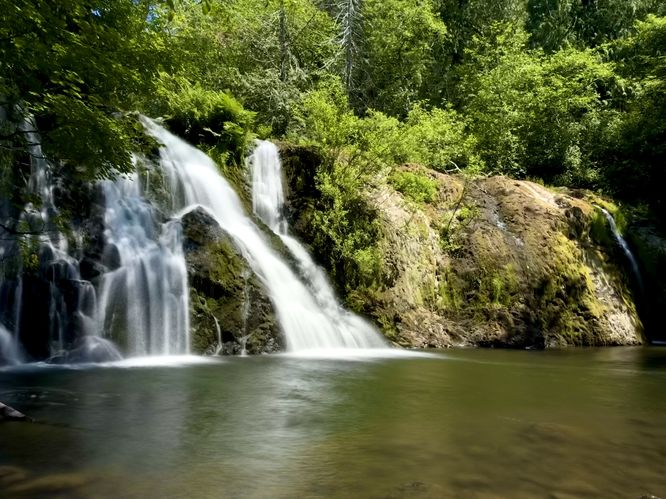
Beaver Creek Falls in Beaver, Washington is a moderate 0.2-mile short hike that leads down to the secluded and scenic 13-foot tall, ~50-foot wide waterfall known as Beaver Creek Falls.
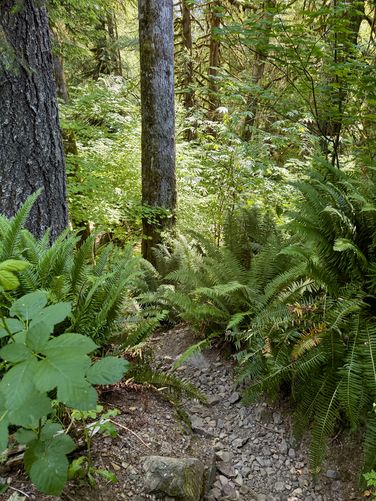
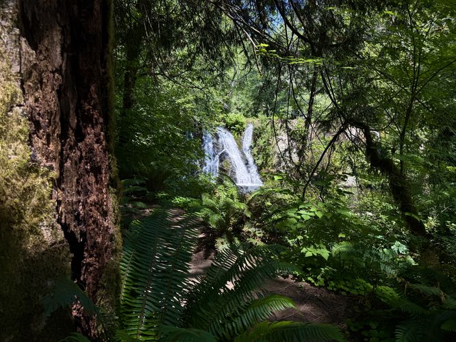
To reach the base of Beaver Creek Falls, start at the parking turnout and head south. Follow the guardrail along the road where you'll find a skinny dirt "path". This dirt path quickly turns eastward into the forest where the trailhead may be a bit overgrown. Follow the trail and pass the cliff side obstructed views of the waterfall as it leads downhill. The trail will turn east and then it'll drop down a steep bank where you'll find a very short and easy scramble.
Once you pass the short creek bank scramble, the hike upstream follows the loose rocks and blowdown trees to reach the base of Beaver Creek Falls. At the waterfall, you'll find a large swimming hole where you can cool off or simply hang out and enjoy the scenery. This secluded and lesser-known spot within the Olympic Peninsula is a great way to enjoy a beautiful waterfall without really any crowds around, though foot traffic may vary depending on the time of year or time of day. We, fortunately, had this spot all to ourselves for about 20 minutes with no sight of other people.
Cliffs: This trail passes by steep and dangerous cliffs. Stay back for your own safety.
Exploring Beaver Creek Falls
Most visitors to Beaver Creek Falls have a difficult time locating the path that leads to the base of the waterfall. If you show up and follow Google Maps instructions, you'll find yourself at the top of a very-steep and dangerous drop-off at the parking area with no indication of where to go. This guide will get you to the base of the waterfall without having to figure it out for yourself!To reach the base of Beaver Creek Falls, start at the parking turnout and head south. Follow the guardrail along the road where you'll find a skinny dirt "path". This dirt path quickly turns eastward into the forest where the trailhead may be a bit overgrown. Follow the trail and pass the cliff side obstructed views of the waterfall as it leads downhill. The trail will turn east and then it'll drop down a steep bank where you'll find a very short and easy scramble.
Once you pass the short creek bank scramble, the hike upstream follows the loose rocks and blowdown trees to reach the base of Beaver Creek Falls. At the waterfall, you'll find a large swimming hole where you can cool off or simply hang out and enjoy the scenery. This secluded and lesser-known spot within the Olympic Peninsula is a great way to enjoy a beautiful waterfall without really any crowds around, though foot traffic may vary depending on the time of year or time of day. We, fortunately, had this spot all to ourselves for about 20 minutes with no sight of other people.
Difficulty
This trail is not all that difficult, but not everyone can do the creek bank scramble or may not want to. If you skip the creek side scramble and do not descend to reach the base of the waterfall, you can still enjoy views of the cascade from the trail high above near the cliffs. If you plan to hike to the base of the waterfall, the trail should be considered "moderate" in difficulty.Parking
There's a small parking turnout located at the coordinates provided on the east side of Burnt Mountain Road in Beaver, Washington. The turnout is large enough to fit less than 10 vehicles as of June 2025.Pets
Dogs are allowed only if leashed and cleaned up after.Warning
Flash flooding: Depending on weather conditions and rainfall upstream, this creek could flash flood without warning at any time. If you plan to hang out around the waterfall, be aware of this danger. Also note that if you plan to swim below the waterfall, this is an increased danger. If swimming, you choose to swim at your own risk.Cliffs: This trail passes by steep and dangerous cliffs. Stay back for your own safety.